more stats
1,253 ft
Distance
-116 ft
Descent
410 ft
High Point
-117 ft
Altitude change
292 ft
Altitude min
410 ft
Altitude start
292 ft
Altitude end
-9.3%
Grade
-24.2%
Grade max
2.1%
Grade min
62 ft
Distance climb
1,188 ft
Distance down

Bacon Pancakes Details

  • Activities
    • Mountain Bike
    • E-Bike
    • Adaptive Bike
  • Riding Area
    MTB Tehaleh
    Bonney Lake, Washington
  • Difficulty Rating
  • Voted Difficulty
    Blue (1 vote)
  • Local Popularity
    60 in Mountain Biking [+]
    • 55 in E-Biking
  • Trail Type
    Singletrack
  • Bike Type
    DH, AM, XC, Adaptive MTB
  • eBike Allowed
    Yes up to Class 1
  • TTFs on Trail
    Berm, Jump

Start slow
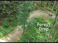
This intermediate jump trail gives you all of the speed to clear the jumps and some are easy to overshoot.

Adaptive Bike Info
aMTB Black Rating: Advanced obstacles exist, some trail obstructions.

Width: 54" Ave. / 48" Min.
Camber: to 17%
Slope: Down to 21% / Up n/a
Tabletop jumps with steep take-offs and landings and steep camber berms.

Adaptive Evaluation Form

View PDF

Local Trail Association
Traditionally Indigenous Territory

Recent Activity on Trail

Past Week
  • 5 rides
  • 8 miles average
6 Months
  • 73 rides
  • 9 miles avg distance
All
  • 315 rides
  • Last: Jun 23, 2026
c1c2c3c4
January
February
March
April
May
June
July
August
September
October
November
December
Status:
on Apr 28, 2026
Ideal
Avg: 4.09 (4 votes)
Your vote: 0

view (1,544)
close
3D
Trail Conditions
  • Unknown
  • Snow Groomed
  • Snow Packed
  • Snow Covered
  • Snow Cover Partial
  • Freeze/thaw Cycle
  • Icy
  • Prevalent Mud
  • Wet
  • Variable
  • Ideal
  • Dry
  • Very Dry
Trail Flow (Ridden Direction)
Trailforks scans users ridelogs to determine the most popular direction each trail is ridden. A good flowing trail network will have most trails flowing in a single direction according to their intension.
The colour categories are based on what percentage of riders are riding a trail in its intended direction.
  • > 96%
  • > 90%
  • > 80%
  • > 70%
  • > 50%
  • < 50%
  • bi-directional trail
  • no data
Trail Last Ridden
Trailforks scans ridelogs to determine the last time a trail was ridden.
  • < 2 days
  • < 1 week
  • < 2 weeks
  • < 1 month
  • < 6 months
  • > 6 months
Trail Ridden Direction
The intended direction a trail should be ridden.
  • Downhill Only
  • Downhill Primary
  • Both Directions
  • Uphill Primary
  • Uphill Only
  • One Direction
Contribute Details
Colors indicate trail is missing specified detail.
  • Description
  • Photos
  • Description & Photos
  • Videos
Trail Popularity ?
Trailforks scans ridelogs to determine which trails are ridden the most in the last 9 months. Trails are compared with nearby trails in the same city region with a possible 25 colour shades. Think of this as a heatmap, more rides = more kinetic energy = warmer colors.
  • most popular
  • popular
  • less popular
  • not popular
ATV/ORV/OHV Filter
Max Vehicle Width
inches
US Cell Coverage
Legend
cell carrier legend

Radar Time
Activity Recordings
Trailforks uses anonymized public activity data. ?
Activity Recordings
Trailforks uses anonymized public activity data. ?
Personal Heatmap
Activity Types
all / none
Options
2
Date range month
Winter Trails
Warning A routing network for winter maps does not exist. Selecting trails using the winter trails layer has been disabled.
Missing Trails
Most Popular
Least Popular
Trails are colored based on popularity. The more popular a trail is, the more red. Less popular trails trend towards green.
Jump Magnitude Heatmap
Heatmap of where riders jump on trails. Zoom in to see individual jumps, click circles to view jump details.
BC Backroad Status

Service Road Atlas is a free to use, community-driven service for viewing and creating reports on the numerous back-country service roads around B.C. and Alberta.

map legend
Slope Aspect
Direction the slope faces
Flat N NE E SE S SW W NW
Trails Deemphasized
Trails are shown in grey.
disable
Only show trails with no bike usage.
Enable
Suggested Layers
Based on selected activity type

    Save the current map location and zoom level as your default home location whenever this page is loaded.

    Save
        Directions to bacon-pancakes trailhead (47.122400, -122.214110)

        Photos

        8 more »
        77 |
        Oct 4, 2025 @ 11:38am
        Oct 4, 2025
        91 |
        Sep 13, 2024 @ 10:23am
        Sep 13, 2024
        62 |
        Aug 12, 2024 @ 11:15pm
        Aug 12, 2024
        204 |
        Jun 2, 2024 @ 10:02am
        Jun 2, 2024

        Videos

        2 more »
        youtuber Tehaleh | Another New Trail System in Washington!
        19:56 | 205 | Jun 24, 2024 , Bonney Lake
        Bacon and Pancakes
        0:52 | 158 | Jun 19, 2024 , Bonney Lake

        3 Reviews & Comments


        We hope you've been enjoying Trailforks!

        Create a FREE account to view trail comments and much more.

        Frequently Asked Questions About Bacon Pancakes

        Where is Bacon Pancakes located?
        Bacon Pancakes is located in MTB Tehaleh, Bonney Lake, Washington, United States. It is part of the MTB Tehaleh trail network. The trailhead is located at coordinates 47.1224, -122.21411.
        How hard is Bacon Pancakes?
        Bacon Pancakes is rated as Blue difficulty. The average grade is 9.3%.
        What is the elevation gain for Bacon Pancakes?
        The trail has 116 ft of elevation descent. The elevation ranges from 292 ft to 410 ft.
        How long is Bacon Pancakes?
        Bacon Pancakes is 1,253 ft long. The trail type is singletrack.

        Hit the Trail

        Open in App

        Get this trail on your phone instantly.
        open trail in app

        Download Trail

        Save to wishlist, Garmin & download.
        save the trail

        Find Related Routes

        Find routes and users activities that include this trail.
        find routes for this trail

        You must enter a description before submitting.