more stats
4.0 miles
Distance
336 ft
Climb
-540 ft
Descent
00:32:28
Avg time
-202 ft
Altitude change
5,516 ft
Altitude min
6,030 ft
Altitude max
5,719 ft
Altitude start
5,518 ft
Altitude end
-1%
Grade
-18.7%
Grade max
26.5%
Grade min
1 mile
Distance climb
2 miles
Distance down
2,116 ft
Distance flat
00:32:28
Avg time

Badger Mountain Details

  • Activities
    • Mountain Bike
    • E-Bike
    • Gravel Bike
    • Adaptive Bike
    • Hike
    • Trail Running
  • Riding Area
    Prescott
    , Arizona
  • Difficulty Rating
  • Voted Difficulty
    Blue (1 vote)
  • Local Popularity
    55 in Mountain Biking [+]
    • 55 in E-Biking
    • 5 in Trail Running
    • 5 in Hiking
  • Global Ranking
    #9223 in Mountain Biking [+]
    • #171478 in Trail Running
    • #161458 in Hiking
  • Trail Type
    Gravel Path
  • Bike Type
    XC, Adaptive MTB, Gravel
  • Direction
    Both Directions
  • Climb Difficulty
    Blue
  • Physical Rating
    Moderate
  • Dogs Allowed
    Yes
  • eBike Allowed
    Yes up to Class 1

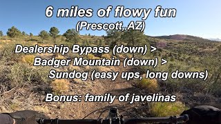
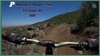
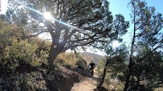
Badger Mountain Trail is one of the final trails to be built to complete the Prescott Circle Trail. It can be accessed from either the Turley Trail from the south or Sundog Ranch Trail from the north.

From Turley, there is about a mile climb to the "P," then the trail descends to Highway 69. This trail is chock-full of speed and flow. Be careful of the other trails users as a few of the corners have limited line of sight.

The view from the top near the "P" is spectacular as you can see from Thumb Butte to the west to The Dells in the east.

Local Trail Association
Traditionally Indigenous Territory

Recent Activity on Trail

Past Week
  • 0 rides
  •  
6 Months
  • 6 rides
  • 28 miles avg distance
All
  • 78 rides
  • Last: Jun 2, 2026
c1c2c3c4
January
February
March
April
May
June
July
August
September
October
November
December
update trails status or condition

Badger Mountain Trail Reports

statusdatedescription
Apr 5, 2026 @ 5:45pm (America/Phoenix)
Apr 5, 2026
Jan 12, 2026 @ 9:32am (America/Phoenix)
Jan 12, 2026
Areas of light to moderate snow cover in the shade. Open areas are a bit wet/muddy but rideable.
Nov 14, 2024 @ 11:44am
Nov 14, 2024
Aug 17, 2024 @ 12:35pm
Aug 17, 2024
North end of Badger Mountain Trail at the tunnel under State Road 69 is currently closed due to road construction and lengthening of the tunnel...
Sep 11, 2023 @ 7:02am
Sep 11, 2023
Great shape
more »
Status:
on Apr 5, 2026
Dry
Avg: 4.42 (8 votes)
Your vote: 0

view (806)
close
3D
Trail Conditions
  • Unknown
  • Snow Groomed
  • Snow Packed
  • Snow Covered
  • Snow Cover Partial
  • Freeze/thaw Cycle
  • Icy
  • Prevalent Mud
  • Wet
  • Variable
  • Ideal
  • Dry
  • Very Dry
Trail Flow (Ridden Direction)
Trailforks scans users ridelogs to determine the most popular direction each trail is ridden. A good flowing trail network will have most trails flowing in a single direction according to their intension.
The colour categories are based on what percentage of riders are riding a trail in its intended direction.
  • > 96%
  • > 90%
  • > 80%
  • > 70%
  • > 50%
  • < 50%
  • bi-directional trail
  • no data
Trail Last Ridden
Trailforks scans ridelogs to determine the last time a trail was ridden.
  • < 2 days
  • < 1 week
  • < 2 weeks
  • < 1 month
  • < 6 months
  • > 6 months
Trail Ridden Direction
The intended direction a trail should be ridden.
  • Downhill Only
  • Downhill Primary
  • Both Directions
  • Uphill Primary
  • Uphill Only
  • One Direction
Contribute Details
Colors indicate trail is missing specified detail.
  • Description
  • Photos
  • Description & Photos
  • Videos
Trail Popularity ?
Trailforks scans ridelogs to determine which trails are ridden the most in the last 9 months. Trails are compared with nearby trails in the same city region with a possible 25 colour shades. Think of this as a heatmap, more rides = more kinetic energy = warmer colors.
  • most popular
  • popular
  • less popular
  • not popular
ATV/ORV/OHV Filter
Max Vehicle Width
inches
US Cell Coverage
Legend
cell carrier legend

Radar Time
Activity Recordings
Trailforks uses anonymized public activity data. ?
Activity Recordings
Trailforks uses anonymized public activity data. ?
Personal Heatmap
Activity Types
all / none
Options
2
Date range month
Winter Trails
Warning A routing network for winter maps does not exist. Selecting trails using the winter trails layer has been disabled.
Missing Trails
Most Popular
Least Popular
Trails are colored based on popularity. The more popular a trail is, the more red. Less popular trails trend towards green.
Jump Magnitude Heatmap
Heatmap of where riders jump on trails. Zoom in to see individual jumps, click circles to view jump details.
BC Backroad Status

Service Road Atlas is a free to use, community-driven service for viewing and creating reports on the numerous back-country service roads around B.C. and Alberta.

map legend
Slope Aspect
Direction the slope faces
Flat N NE E SE S SW W NW
Trails Deemphasized
Trails are shown in grey.
disable
Only show trails with no bike usage.
Enable
Suggested Layers
Based on selected activity type

    Save the current map location and zoom level as your default home location whenever this page is loaded.

    Save
        Directions to badger-mountain trailhead (34.539160, -112.438150)

        Photos

        15 more »
        114 |
        Nov 7, 2023 @ 3:13pm
        Nov 7, 2023
        114 |
        Jun 17, 2020 @ 12:18pm
        Jun 17, 2020
        107 |
        Jun 17, 2020 @ 12:18pm
        Jun 17, 2020
        149 |
        Aug 24, 2019 @ 1:11pm
        Aug 24, 2019

        Videos

        5 more »
        Dealership Bypass - Badger Mtn - Sundog +...
        23:27 | 85 | Jul 15, 2025 , Prescott
        P Mountain Badger Trail Prescott AZ Mountain...
        18:31 | 571 | Jun 30, 2020 , Prescott
        Uber Ride Prescott
        10:24 | 297 | Oct 28, 2019 , Prescott
        Prescott Vacation Pt 2
        12:30 | 397 | Oct 8, 2018 , Prescott

        Routes with this trail

        5.0 35 miles 2,906 ft 5
        Start at North Peavine trailhead (by hwy 89A), ride South on Peavine to left on Headwaters trail to right...
        5.0 12 miles 1,342 ft 5 Loop
        Riding the direction shown provides a fairly easy 3.5 mile climb (non-technical, usually 2-5% grade)...
        15 miles 1,643 ft 6
        Wonderfully fun shuttle that has a nice amount of climbing with plenty of very fun descents. Climb descend...

        4 Reviews & Comments


        We hope you've been enjoying Trailforks!

        Create a FREE account to view trail comments and much more.

        • By schillingsworthTF Pro TRAILFORKS HTA & contributors
        • #33228 - 8,294 views

        Frequently Asked Questions About Badger Mountain

        Where is Badger Mountain located?
        Badger Mountain is located in Prescott, Arizona, United States. It is part of the Prescott trail network. The trailhead is located at coordinates 34.53916, -112.43815.
        How hard is Badger Mountain?
        Badger Mountain is rated as Blue difficulty. The physical rating is Moderate. The average grade is 1%. The climb difficulty is rated Blue.
        What is the elevation gain for Badger Mountain?
        Badger Mountain has 336 ft of elevation gain. The trail has 540 ft of elevation descent. The elevation ranges from 5,516 ft to 6,030 ft.
        Is Badger Mountain a point to point trail?
        Badger Mountain is not a point to point trail. The direction is Both Directions. The trail type is gravel path.

        Hit the Trail

        Open in App

        Get this trail on your phone instantly.
        open trail in app

        Download Trail

        Save to wishlist, Garmin & download.
        save the trail

        Find Related Routes

        Find routes and users activities that include this trail.
        find routes for this trail

        You must enter a description before submitting.