more stats
1,900 ft
Distance
-91 ft
Descent
00:02:13
Avg time
-91 ft
Altitude change
4,297 ft
Altitude min
4,387 ft
Altitude max
4,387 ft
Altitude start
4,298 ft
Altitude end
-4.8%
Grade
-18%
Grade max
-1.2%
Grade min
1,900 ft
Distance down
00:02:13
Avg time

Bail Details

  • Activities
    • Mountain Bike
    • Adaptive Bike
    • Horse
    • Hike
    • Trail Running
  • Riding Area
    Bell Rock
    Village Of Oak Creek, Arizona
  • Difficulty Rating
  • Local Popularity
    70 in Mountain Biking [+]
    • 80 in Trail Running
    • 70 in Hiking
    • 5 in Horseback
  • Global Ranking
    #5244 in Mountain Biking [+]
    • #62800 in Trail Running
    • #82513 in Hiking
  • Trail Type
    Singletrack
  • Bike Type
  • Direction
    Both Directions
  • Dogs Allowed
    Yes
  • eBike Allowed

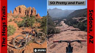
Intermediate 85% and advanced 15%, 1/3 mile MTB trail which is a bi-directional singletrack that is mostly downhill from north to south. There are a few technical sections and the trail tread is mostly packed dirt mixed with rocks. This is a very popular connector to get riders back to Belll Rock Pathway who are tired of riding Lama south bound. There is no preferred direction and the trail is a great for several other fun loops.

Adaptive Bike Info
aMTB Green Rating: Beginner features and moderate terrain.
Trail Supporters

  • USFS
    Land Manager
Local Trail Association

Recent Activity on Trail

Past Week
  • 2 rides
  • 9 miles average
6 Months
  • 135 rides
  • 13 miles avg distance
All
  • 1,027 rides
  • Last: Jun 13, 2026
c1c2c3c4
January
February
March
April
May
June
July
August
September
October
November
December
Status:
on Jan 22, 2026
Dry
Avg: 3.68 (10 votes)
Your vote: 0

view (4,601)
close
3D
Trail Conditions
  • Unknown
  • Snow Groomed
  • Snow Packed
  • Snow Covered
  • Snow Cover Partial
  • Freeze/thaw Cycle
  • Icy
  • Prevalent Mud
  • Wet
  • Variable
  • Ideal
  • Dry
  • Very Dry
Trail Flow (Ridden Direction)
Trailforks scans users ridelogs to determine the most popular direction each trail is ridden. A good flowing trail network will have most trails flowing in a single direction according to their intension.
The colour categories are based on what percentage of riders are riding a trail in its intended direction.
  • > 96%
  • > 90%
  • > 80%
  • > 70%
  • > 50%
  • < 50%
  • bi-directional trail
  • no data
Trail Last Ridden
Trailforks scans ridelogs to determine the last time a trail was ridden.
  • < 2 days
  • < 1 week
  • < 2 weeks
  • < 1 month
  • < 6 months
  • > 6 months
Trail Ridden Direction
The intended direction a trail should be ridden.
  • Downhill Only
  • Downhill Primary
  • Both Directions
  • Uphill Primary
  • Uphill Only
  • One Direction
Contribute Details
Colors indicate trail is missing specified detail.
  • Description
  • Photos
  • Description & Photos
  • Videos
Trail Popularity ?
Trailforks scans ridelogs to determine which trails are ridden the most in the last 9 months. Trails are compared with nearby trails in the same city region with a possible 25 colour shades. Think of this as a heatmap, more rides = more kinetic energy = warmer colors.
  • most popular
  • popular
  • less popular
  • not popular
ATV/ORV/OHV Filter
Max Vehicle Width
inches
US Cell Coverage
Legend
cell carrier legend

Radar Time
Activity Recordings
Trailforks uses anonymized public activity data. ?
Activity Recordings
Trailforks uses anonymized public activity data. ?
Personal Heatmap
Activity Types
all / none
Options
2
Date range month
Winter Trails
Warning A routing network for winter maps does not exist. Selecting trails using the winter trails layer has been disabled.
Missing Trails
Most Popular
Least Popular
Trails are colored based on popularity. The more popular a trail is, the more red. Less popular trails trend towards green.
Jump Magnitude Heatmap
Heatmap of where riders jump on trails. Zoom in to see individual jumps, click circles to view jump details.
BC Backroad Status

Service Road Atlas is a free to use, community-driven service for viewing and creating reports on the numerous back-country service roads around B.C. and Alberta.

map legend
Slope Aspect
Direction the slope faces
Flat N NE E SE S SW W NW
Trails Deemphasized
Trails are shown in grey.
disable
Only show trails with no bike usage.
Enable
Suggested Layers
Based on selected activity type

    Save the current map location and zoom level as your default home location whenever this page is loaded.

    Save
        Directions to bail-14973 trailhead (34.815910, -111.760960)

        Photos

        9 more »
        40 |
        Sep 17, 2022 @ 7:31am
        Sep 17, 2022
        37 |
        Sep 17, 2022 @ 7:31am
        Sep 17, 2022
        38 |
        Sep 17, 2022 @ 7:31am
        Sep 17, 2022
        43 |
        Sep 17, 2022 @ 7:31am
        Sep 17, 2022

        Videos

        2 more »
        youtuber Sedona's Hogs Trails are awesome! | Mountain...
        36:46 | 24 | Apr 24, 2026 , Village Of Oak Creek
        Sedona MTB // Llama Trail for Beginners
        11:20 | 312 | Jun 7, 2020 , Village Of Oak Creek

        Trail Lists

        Routes with this trail

        5.0 7 miles 590 ft 6 Loop
        Get warmed up on (BRP) and before hopping on to access . can be ridden both directions, but we find it...
        3.0 6 miles 554 ft 12 Loop
        This is a good short loop that includes the descent down which is one of the best descents in Sedona....
        4 miles 271 ft 2 Loop
        Still feeling like keeping it tame but want to test yourself on a little bit of tech? This loop will take...

        Reviews / Comments

        No reviews yet, be the first to write a review or ask a question.
        Use trail reports to comment on trail conditions.


        We hope you've been enjoying Trailforks!

        Create a FREE account to view trail comments and much more.

        • By toddTF Pro Trailforks & contributors
        • #14973 - 2,614 views

        Frequently Asked Questions About Bail

        Where is Bail located?
        Bail is located in Bell Rock, Village Of Oak Creek, Arizona, United States. It is part of the Bell Rock trail network. The trailhead is located at coordinates 34.81591, -111.76096.
        How hard is Bail?
        Bail is rated as Blue difficulty. The average grade is 4.8%.
        What is the elevation gain for Bail?
        The trail has 91 ft of elevation descent. The elevation ranges from 4,297 ft to 4,387 ft.
        Is Bail a point to point trail?
        Bail is not a point to point trail. The direction is Both Directions. The trail type is singletrack.

        Hit the Trail

        Open in App

        Get this trail on your phone instantly.
        open trail in app

        Download Trail

        Save to wishlist, Garmin & download.
        save the trail

        Find Related Routes

        Find routes and users activities that include this trail.
        find routes for this trail

        You must enter a description before submitting.