more stats
1.8 miles
Distance
59 ft
Climb
-387 ft
Descent
00:23:19
Avg time
-328 ft
Altitude change
1,670 ft
Altitude min
2,057 ft
Altitude max
1,998 ft
Altitude start
1,670 ft
Altitude end
-3.4%
Grade
-37.9%
Grade max
7.8%
Grade min
2,329 ft
Distance climb
1 mile
Distance down
482 ft
Distance flat
00:23:19
Avg time

Bald Eagle Details

  • Activities
    • Mountain Bike
    • E-Bike
    • Winter Fat Bike
    • Hike
    • Trail Running
  • Riding Area
    Jakes Rocks
    Warren, Pennsylvania
  • Difficulty Rating
  • Voted Difficulty
    Black Diamond (1 vote)
  • Local Popularity
    80 in Mountain Biking [+]
    • 70 in E-Biking
    • 5 in Trail Running
    • 5 in Hiking
  • Global Ranking
    #60176 in Mountain Biking [+]
    • #129940 in Trail Running
    • #122868 in Hiking
  • Hiking SAC Scale
    T2 Mountain Hiking
  • Trail Type
    Singletrack
  • Bike Type
    AM, XC, Fat
  • Direction
    Both Directions
    Popular Direction Shown
  • Climb Difficulty
    Black Diamond
  • Physical Rating
    Hard
  • Dogs Allowed
    Yes
  • eBike Allowed
  • TTFs on Trail
    Drop, Rock Garden
  • Land Owner
    USFS

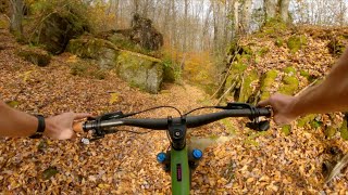
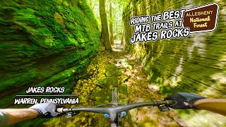
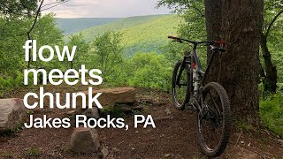
Bald Eagle is one the premier black diamond trails at Jake's Rocks. This trail features lots of rocks Rocks, rocks, rocks are the name of the game at Bald Eagle. There are many rock gardens and a few rock drops scattered throughout this trail.

Bald Eagle starts about halfway down Elijah Too and rejoins the same trail most of the way down to Longhouse Drive. The top of Bald Eagle is similar to Elijah Too but somewhat more rocky, it is a traverse to a scenic overlook where you can take a rest on some natural rock benches. After the scenic overlook, the descent begins! This trail will keep you on your toes, trying to find the flow through the rock gardens. About 2/3 of the way down keep an eye out for an optional rock slab drop to the left.

At the end of Bald Eagle you can continue down Elijah Too to Longhouse Drive or climb up Elijah Too to make your way back to the top of Elijah and back to the rest of the Jake's Rocks trails.

Trail Supporters
  • NAMBA
    Sponsor
Local Trail Association
Traditionally Indigenous Territory

Recent Activity on Trail

Past Week
  • 1 rides
  • 21 miles average
6 Months
  • 16 rides
  • 28 miles avg distance
All
  • 169 rides
  • Last: Jun 19, 2026
c1c2c3c4
January
February
March
April
May
June
July
August
September
October
November
December
update trails status or condition

Bald Eagle Trail Reports

Status:
on Sep 20, 2025
Very Dry
Avg: 4.07 (6 votes)
Your vote: 0

view (639)
close
3D
Trail Conditions
  • Unknown
  • Snow Groomed
  • Snow Packed
  • Snow Covered
  • Snow Cover Partial
  • Freeze/thaw Cycle
  • Icy
  • Prevalent Mud
  • Wet
  • Variable
  • Ideal
  • Dry
  • Very Dry
Trail Flow (Ridden Direction)
Trailforks scans users ridelogs to determine the most popular direction each trail is ridden. A good flowing trail network will have most trails flowing in a single direction according to their intension.
The colour categories are based on what percentage of riders are riding a trail in its intended direction.
  • > 96%
  • > 90%
  • > 80%
  • > 70%
  • > 50%
  • < 50%
  • bi-directional trail
  • no data
Trail Last Ridden
Trailforks scans ridelogs to determine the last time a trail was ridden.
  • < 2 days
  • < 1 week
  • < 2 weeks
  • < 1 month
  • < 6 months
  • > 6 months
Trail Ridden Direction
The intended direction a trail should be ridden.
  • Downhill Only
  • Downhill Primary
  • Both Directions
  • Uphill Primary
  • Uphill Only
  • One Direction
Contribute Details
Colors indicate trail is missing specified detail.
  • Description
  • Photos
  • Description & Photos
  • Videos
Trail Popularity ?
Trailforks scans ridelogs to determine which trails are ridden the most in the last 9 months. Trails are compared with nearby trails in the same city region with a possible 25 colour shades. Think of this as a heatmap, more rides = more kinetic energy = warmer colors.
  • most popular
  • popular
  • less popular
  • not popular
ATV/ORV/OHV Filter
Max Vehicle Width
inches
US Cell Coverage
Legend
cell carrier legend

Radar Time
Activity Recordings
Trailforks uses anonymized public activity data. ?
Activity Recordings
Trailforks uses anonymized public activity data. ?
Personal Heatmap
Activity Types
all / none
Options
2
Date range month
Winter Trails
Warning A routing network for winter maps does not exist. Selecting trails using the winter trails layer has been disabled.
Missing Trails
Most Popular
Least Popular
Trails are colored based on popularity. The more popular a trail is, the more red. Less popular trails trend towards green.
Jump Magnitude Heatmap
Heatmap of where riders jump on trails. Zoom in to see individual jumps, click circles to view jump details.
BC Backroad Status

Service Road Atlas is a free to use, community-driven service for viewing and creating reports on the numerous back-country service roads around B.C. and Alberta.

map legend
Slope Aspect
Direction the slope faces
Flat N NE E SE S SW W NW
Trails Deemphasized
Trails are shown in grey.
disable
Only show trails with no bike usage.
Enable
Suggested Layers
Based on selected activity type

    Save the current map location and zoom level as your default home location whenever this page is loaded.

    Save
        Directions to bald-eagle-221044 trailhead (41.818600, -78.962980)

        Photos

        14 more »
        63 |
        Aug 23, 2025 @ 1:23pm
        Aug 23, 2025
        362 |
        Sep 29, 2020 @ 3:04pm
        Sep 29, 2020
        376 |
        Jul 7, 2020 @ 8:20am
        Jul 7, 2020
        332 |
        Jul 7, 2020 @ 8:20am
        Jul 7, 2020

        Videos

        3 more »
        youtuber Bald Eagle (Jakes Rocks) / Warren, PA / MTB
        8:43 | 207 | Dec 15, 2023 , Warren
        This Place Rocks : A Guide to the Best Trails...
        19:36 | 188 | Jul 29, 2024 , Warren
        Where flow meets chunk // Elijah to Bald Eagle...
        11:48 | 438 | Oct 8, 2020 , Warren

        Routes with this trail

        5.0 21 miles 3,140 ft 11
        Tried to hit all the blacks and the fun downhill stuff.

        10 Reviews & Comments


        We hope you've been enjoying Trailforks!

        Create a FREE account to view trail comments and much more.

        Nearby Trails

        • By jpa102TF Pro & contributors
        • #221044 - 2,307 views

        Frequently Asked Questions About Bald Eagle

        Where is Bald Eagle located?
        Bald Eagle is located in Jakes Rocks, Warren, Pennsylvania, United States. It is part of the Jakes Rocks trail network. The trailhead is located at coordinates 41.8186, -78.96298.
        How hard is Bald Eagle?
        Bald Eagle is rated as Black Diamond difficulty. The physical rating is Hard. The average grade is 3.4%. The climb difficulty is rated Black Diamond.
        What is the elevation gain for Bald Eagle?
        Bald Eagle has 59 ft of elevation gain. The trail has 387 ft of elevation descent. The elevation ranges from 1,670 ft to 2,057 ft.
        Is Bald Eagle a point to point trail?
        Bald Eagle is not a point to point trail. The direction is Both Directions. The trail type is singletrack.

        Hit the Trail

        Open in App

        Get this trail on your phone instantly.
        open trail in app

        Download Trail

        Save to wishlist, Garmin & download.
        save the trail

        Find Related Routes

        Find routes and users activities that include this trail.
        find routes for this trail

        You must enter a description before submitting.