more stats
4,624 ft
Distance
13 ft
Climb
-312 ft
Descent
00:03:18
Avg time
-299 ft
Altitude change
6,441 ft
Altitude min
6,740 ft
Altitude max
6,740 ft
Altitude start
6,441 ft
Altitude end
-6.47%
Grade
-20.365%
Grade max
7.4%
Grade min
485 ft
Distance climb
3,696 ft
Distance down
378 ft
Distance flat
00:03:18
Avg time

Bandit Details

  • Activities
    • Mountain Bike
  • Riding Area
    Jackson Hole Mountain Resort
    Teton Village, Wyoming
  • Difficulty Rating
  • Voted Difficulty
    Blue (3 votes)
  • Local Popularity
    95 in Mountain Biking
  • Global Ranking
    #25801 in Mountain Biking
  • Trail Type
    Singletrack
  • Direction
    Downhill Only
    Popular Direction Shown
  • Dogs Allowed
    Yes
  • Land Owner
    Jackson Hole Mountain Resort

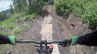
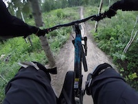
This trail is really my favorite. It starts off with a bang with an option little trellis drop then you maintain your speed a pedal a bit to make the first table top. After that it is table top after table top. You can role them slowly and it is really a beginner trail. The jumps can have some good distance but you don't go too high. If you don't make the table top you just land on top. The jumps take you across a field where the little gondola is taking hikers up to the top as you hit the jumps below.

Trail Supporters

  • USFS
    Land Manager

Bike Park

Traditionally Indigenous Territory

Recent Activity on Trail

Past Week
  • 5 rides
  • 44 miles average
6 Months
  • 6 rides
  • 41 miles avg distance
All
  • 298 rides
  • Last: Jun 23, 2026
c1c2c3c4
January
February
March
April
May
June
July
August
September
October
November
December
Status:
on Jul 27, 2025
Ideal
Avg: 4.33 (10 votes)
Your vote: 0

view (4,405)
close
3D
Trail Conditions
  • Unknown
  • Snow Groomed
  • Snow Packed
  • Snow Covered
  • Snow Cover Partial
  • Freeze/thaw Cycle
  • Icy
  • Prevalent Mud
  • Wet
  • Variable
  • Ideal
  • Dry
  • Very Dry
Trail Flow (Ridden Direction)
Trailforks scans users ridelogs to determine the most popular direction each trail is ridden. A good flowing trail network will have most trails flowing in a single direction according to their intension.
The colour categories are based on what percentage of riders are riding a trail in its intended direction.
  • > 96%
  • > 90%
  • > 80%
  • > 70%
  • > 50%
  • < 50%
  • bi-directional trail
  • no data
Trail Last Ridden
Trailforks scans ridelogs to determine the last time a trail was ridden.
  • < 2 days
  • < 1 week
  • < 2 weeks
  • < 1 month
  • < 6 months
  • > 6 months
Trail Ridden Direction
The intended direction a trail should be ridden.
  • Downhill Only
  • Downhill Primary
  • Both Directions
  • Uphill Primary
  • Uphill Only
  • One Direction
Contribute Details
Colors indicate trail is missing specified detail.
  • Description
  • Photos
  • Description & Photos
  • Videos
Trail Popularity ?
Trailforks scans ridelogs to determine which trails are ridden the most in the last 9 months. Trails are compared with nearby trails in the same city region with a possible 25 colour shades. Think of this as a heatmap, more rides = more kinetic energy = warmer colors.
  • most popular
  • popular
  • less popular
  • not popular
ATV/ORV/OHV Filter
Max Vehicle Width
inches
US Cell Coverage
Legend
cell carrier legend

Radar Time
Activity Recordings
Trailforks uses anonymized public activity data. ?
Activity Recordings
Trailforks uses anonymized public activity data. ?
Personal Heatmap
Activity Types
all / none
Options
2
Date range month
Winter Trails
Warning A routing network for winter maps does not exist. Selecting trails using the winter trails layer has been disabled.
Missing Trails
Most Popular
Least Popular
Trails are colored based on popularity. The more popular a trail is, the more red. Less popular trails trend towards green.
Jump Magnitude Heatmap
Heatmap of where riders jump on trails. Zoom in to see individual jumps, click circles to view jump details.
BC Backroad Status

Service Road Atlas is a free to use, community-driven service for viewing and creating reports on the numerous back-country service roads around B.C. and Alberta.

map legend
Slope Aspect
Direction the slope faces
Flat N NE E SE S SW W NW
Trails Deemphasized
Trails are shown in grey.
disable
Only show trails with no bike usage.
Enable
Suggested Layers
Based on selected activity type

    Save the current map location and zoom level as your default home location whenever this page is loaded.

    Save
        Directions to bandit-35344 trailhead (43.595840, -110.830770)

        Photos

        9 more »
        406 |
        Sep 1, 2012 @ 9:04pm
        Sep 1, 2012
        572 |
        Jul 1, 2014 @ 8:39pm
        Jul 1, 2014
        168 |
        Aug 28, 2016 @ 8:18pm
        Aug 28, 2016
        153 |
        Aug 28, 2016 @ 8:18pm
        Aug 28, 2016

        Videos

        9 more »
        Jackson Hole Bike Park
        12:42 | 425 | May 20, 2020 , Teton Village
        Biking Jackson Hole Mountain Resort
        12:42 | 300 | Oct 31, 2019 , Teton Village
        Funky Frittatas
        0:55 | 188 | Jun 19, 2017 , Teton Village
        Jackson Hole Bike Park - Bandit/True Grit
        4:32 | 461 | Jul 16, 2014 , Teton Village

        Trail Events

        4 Reviews & Comments


        We hope you've been enjoying Trailforks!

        Create a FREE account to view trail comments and much more.

        • By toddTF Pro Trailforks & contributors
        • #35344 - 2,881 views

        Frequently Asked Questions About Bandit

        Where is Bandit located?
        Bandit is located in Jackson Hole Mountain Resort, Teton Village, Wyoming, United States. It is part of the Jackson Hole Mountain Resort trail network. The trailhead is located at coordinates 43.59584, -110.83077.
        How hard is Bandit?
        Bandit is rated as Blue difficulty. The average grade is 6.47%.
        What is the elevation gain for Bandit?
        Bandit has 4 m of elevation gain. The trail has 95 m of elevation descent. The elevation ranges from 1,963 m to 2,054 m.
        Is Bandit a point to point trail?
        Yes, Bandit is a point to point trail. The direction is Downhill Only. The trail type is singletrack.

        Hit the Trail

        Open in App

        Get this trail on your phone instantly.
        open trail in app

        Download Trail

        Save to wishlist, Garmin & download.
        save the trail

        Find Related Routes

        Find routes and users activities that include this trail.
        find routes for this trail

        You must enter a description before submitting.