more stats
1.2 miles
Distance
814 ft
Climb
00:22:15
Avg time
816 ft
Altitude change
3,474 ft
Altitude min
4,290 ft
Altitude max
3,474 ft
Altitude start
4,291 ft
Altitude end
12.4%
Grade
0.6%
Grade max
45.2%
Grade min
1 mile
Distance climb
52 ft
Distance flat
00:22:15
Avg time

Barmeyer Trail Details

  • Activities
    • Mountain Bike
    • Hike
    • Trail Running
    • Snowshoe
  • Riding Area
    Dean Stone
    Missoula, Montana
  • Difficulty Rating
  • Global Ranking
    #172747 in Mountain Biking [+]
    • #139540 in Trail Running
    • #129335 in Hiking
  • Hiking SAC Scale
    T2 Mountain Hiking
  • Trail Type
    Singletrack
  • Snow Grooming
    Backcountry
  • Bike Type
    AM, XC
  • Direction
    Both Directions
    Popular In Reverse
  • Climb Difficulty
    Blue
  • Physical Rating
    Moderate
  • Trail Visibility
    Always easy to follow
  • Family Friendly
    Yes
  • Dogs Allowed
    Yes
  • eBike Allowed
  • Land Owner
    City of Missoula

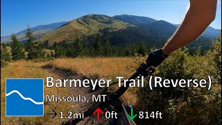
The trail starts out as a wide path meandering uphill through a forest with large sparsely spaced trees and abundant shade. After the split with the Barmeyer Loop trail it breaks out above the trees into grassy slopes with good views of Mount Sentinel and the mountains north of Missoula. After a split with the Barmeyer Overlook path the trail follows an old road for a short distance and then drops into the trees, crosses a dirt road, and descends through a few switchbacks before breaking out into a grassy hillside with great views of the Missoula Valley. The trail traverses below a driveway and ends at a small trailhead on Spanish Peaks Drive.

Access Info

The eastern end of the trail is on Pattee Canyon Drive and there is a small parking lot at the trailhead. The western end is at the Sousa Trailhead at a switchback in Spanish Peaks Drive. There is no parking lot at the Sousa Trailhead but on-street parking is available.

Local Trail Association
Traditionally Indigenous Territory

Recent Activity on Trail

Past Week
  • 2 rides
  • 10 miles average
6 Months
  • 38 rides
  • 14 miles avg distance
All
  • 363 rides
  • Last: Jun 19, 2026
c1c2c3c4
January
February
March
April
May
June
July
August
September
October
November
December
update trails status or condition

Barmeyer Trail Trail Reports

Status:
on Jan 15, 2026
Variable
Avg: 3.65 (3 votes)
Your vote: 0

view (0)
close
3D
Trail Conditions
  • Unknown
  • Snow Groomed
  • Snow Packed
  • Snow Covered
  • Snow Cover Partial
  • Freeze/thaw Cycle
  • Icy
  • Prevalent Mud
  • Wet
  • Variable
  • Ideal
  • Dry
  • Very Dry
Trail Flow (Ridden Direction)
Trailforks scans users ridelogs to determine the most popular direction each trail is ridden. A good flowing trail network will have most trails flowing in a single direction according to their intension.
The colour categories are based on what percentage of riders are riding a trail in its intended direction.
  • > 96%
  • > 90%
  • > 80%
  • > 70%
  • > 50%
  • < 50%
  • bi-directional trail
  • no data
Trail Last Ridden
Trailforks scans ridelogs to determine the last time a trail was ridden.
  • < 2 days
  • < 1 week
  • < 2 weeks
  • < 1 month
  • < 6 months
  • > 6 months
Trail Ridden Direction
The intended direction a trail should be ridden.
  • Downhill Only
  • Downhill Primary
  • Both Directions
  • Uphill Primary
  • Uphill Only
  • One Direction
Contribute Details
Colors indicate trail is missing specified detail.
  • Description
  • Photos
  • Description & Photos
  • Videos
Trail Popularity ?
Trailforks scans ridelogs to determine which trails are ridden the most in the last 9 months. Trails are compared with nearby trails in the same city region with a possible 25 colour shades. Think of this as a heatmap, more rides = more kinetic energy = warmer colors.
  • most popular
  • popular
  • less popular
  • not popular
ATV/ORV/OHV Filter
Max Vehicle Width
inches
US Cell Coverage
Legend
cell carrier legend

Radar Time
Activity Recordings
Trailforks uses anonymized public activity data. ?
Activity Recordings
Trailforks uses anonymized public activity data. ?
Personal Heatmap
Activity Types
all / none
Options
2
Date range month
Winter Trails
Warning A routing network for winter maps does not exist. Selecting trails using the winter trails layer has been disabled.
Missing Trails
Most Popular
Least Popular
Trails are colored based on popularity. The more popular a trail is, the more red. Less popular trails trend towards green.
Jump Magnitude Heatmap
Heatmap of where riders jump on trails. Zoom in to see individual jumps, click circles to view jump details.
BC Backroad Status

Service Road Atlas is a free to use, community-driven service for viewing and creating reports on the numerous back-country service roads around B.C. and Alberta.

map legend
Slope Aspect
Direction the slope faces
Flat N NE E SE S SW W NW
Trails Deemphasized
Trails are shown in grey.
disable
Only show trails with no bike usage.
Enable
Suggested Layers
Based on selected activity type

    Save the current map location and zoom level as your default home location whenever this page is loaded.

    Save
        Directions to barmeyer-trail trailhead (46.829590, -113.979070)

        Photos

        13 more »
        117 |
        Jun 30, 2022 @ 10:28pm
        Jun 30, 2022
        134 |
        Jun 30, 2022 @ 10:27pm
        Jun 30, 2022
        76 |
        Jun 29, 2022 @ 6:25am
        Jun 29, 2022
        107 |
        Apr 29, 2022 @ 6:18pm
        Apr 29, 2022

        Videos

        1 more »
        youtuber Barmeyer Trail - Mt Dean Stone - Missoula, MT
        6:11 | 276 | Jul 19, 2022 , Missoula

        Routes with this trail

        5.0 15 miles 2,783 ft 6 Loop
        A loop from the that climbs a combination of pavement, singletrack, and gravel roads up to the , and...
        4.0 26 miles 3,325 ft 8 Loop
        Mostly trails, some double track and gravel roads, conditioning ride. Bring plenty of water.
        11 miles 1,977 ft 7 Loop
        This route provides a way to link the Barmeyer and Moz trails into a loop with two good climbs and fun...

        2 Reviews & Comments


        We hope you've been enjoying Trailforks!

        Create a FREE account to view trail comments and much more.

        • By Doubleblack23 & contributors
        • #199186 - 5,407 views

        Frequently Asked Questions About Barmeyer Trail

        Where is Barmeyer Trail located?
        Barmeyer Trail is located in Dean Stone, Missoula, Montana, United States. It is part of the Dean Stone trail network. The trailhead is located at coordinates 46.82959, -113.97907.
        How hard is Barmeyer Trail?
        Barmeyer Trail is rated as Blue difficulty. The physical rating is Moderate. The average grade is 12.4%. The climb difficulty is rated Blue.
        What is the elevation gain for Barmeyer Trail?
        Barmeyer Trail has 814 ft of elevation gain. The elevation ranges from 3,474 ft to 4,290 ft.
        Is Barmeyer Trail a point to point trail?
        Barmeyer Trail is not a point to point trail. The direction is Both Directions. The trail type is singletrack.

        Hit the Trail

        Open in App

        Get this trail on your phone instantly.
        open trail in app

        Download Trail

        Save to wishlist, Garmin & download.
        save the trail

        Find Related Routes

        Find routes and users activities that include this trail.
        find routes for this trail

        You must enter a description before submitting.