more stats
1.9 miles
Distance
188 ft
Climb
-581 ft
Descent
00:27:09
Avg time
-393 ft
Altitude change
2,946 ft
Altitude min
3,339 ft
Altitude max
3,338 ft
Altitude start
2,946 ft
Altitude end
-3.965%
Grade
-116.868%
Grade max
45.135%
Grade min
2,136 ft
Distance climb
1 mile
Distance down
1,096 ft
Distance flat
00:27:09
Avg time

Barrel Details

  • Activities
    • Mountain Bike
    • Hike
    • Trail Running
  • Riding Area
    Green Valley
    St. George, Utah
  • Difficulty Rating
  • Voted Difficulty
    Double Black Diamond (3 votes)
  • Local Popularity
    90 in Mountain Biking [+]
    • 75 in Trail Running
    • 60 in Hiking
  • Global Ranking
    #6764 in Mountain Biking [+]
    • #9457 in Trail Running
    • #53461 in Hiking
  • Trail Type
    Singletrack
  • Direction
    Downhill Primary
    Popular Direction Shown
  • Climb Difficulty
    Double Black Diamond
  • Physical Rating
    Extreme
  • Dogs Allowed
    Yes

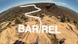
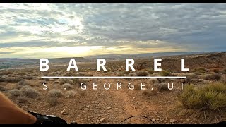
Awesome trail, with some fun terrain. The top part has has the waterfall section that is a fun rough rock descent that takes some skill, while the bottom section has a bunch of jump lines and optional gaps.

Trail Supporters
  • BLM
    BLM
    Land Manager
Local Trail Association
Traditionally Indigenous Territory

Recent Activity on Trail

Past Week
  • 1 rides
  • 7.6 km average
6 Months
  • 141 rides
  • 34.3 km avg distance
All
  • 790 rides
  • Last: Jun 12, 2026
c1c2c3c4
January
February
March
April
May
June
July
August
September
October
November
December
update trails status or condition

Barrel Trail Reports

statusdatedescription
Apr 18, 2026 @ 9:58am (America/Phoenix)
Apr 18, 2026
Perfect dirt for southern Utah.
Mar 21, 2026 @ 8:03am (America/Phoenix)
Mar 21, 2026
Feb 23, 2026 @ 1:31pm (America/Denver)
Feb 23, 2026
The wet was good for it.
Dec 25, 2025 @ 12:35pm (America/Phoenix)
Dec 25, 2025
Nov 26, 2025 @ 12:55pm (America/Phoenix)
Nov 26, 2025
Maybe still tougher than normal but it was pretty clear and not as rough as I expected it to be. But I am a newbie to the area.
more »
Status:
on Apr 18, 2026
Dry
Avg: 4.38 (62 votes)
Your vote: 0

view (6,422)
close
3D
Trail Conditions
  • Unknown
  • Snow Groomed
  • Snow Packed
  • Snow Covered
  • Snow Cover Partial
  • Freeze/thaw Cycle
  • Icy
  • Prevalent Mud
  • Wet
  • Variable
  • Ideal
  • Dry
  • Very Dry
Trail Flow (Ridden Direction)
Trailforks scans users ridelogs to determine the most popular direction each trail is ridden. A good flowing trail network will have most trails flowing in a single direction according to their intension.
The colour categories are based on what percentage of riders are riding a trail in its intended direction.
  • > 96%
  • > 90%
  • > 80%
  • > 70%
  • > 50%
  • < 50%
  • bi-directional trail
  • no data
Trail Last Ridden
Trailforks scans ridelogs to determine the last time a trail was ridden.
  • < 2 days
  • < 1 week
  • < 2 weeks
  • < 1 month
  • < 6 months
  • > 6 months
Trail Ridden Direction
The intended direction a trail should be ridden.
  • Downhill Only
  • Downhill Primary
  • Both Directions
  • Uphill Primary
  • Uphill Only
  • One Direction
Contribute Details
Colors indicate trail is missing specified detail.
  • Description
  • Photos
  • Description & Photos
  • Videos
Trail Popularity ?
Trailforks scans ridelogs to determine which trails are ridden the most in the last 9 months. Trails are compared with nearby trails in the same city region with a possible 25 colour shades. Think of this as a heatmap, more rides = more kinetic energy = warmer colors.
  • most popular
  • popular
  • less popular
  • not popular
ATV/ORV/OHV Filter
Max Vehicle Width
inches
US Cell Coverage
Legend
cell carrier legend

Radar Time
Activity Recordings
Trailforks uses anonymized public activity data. ?
Activity Recordings
Trailforks uses anonymized public activity data. ?
Personal Heatmap
Activity Types
all / none
Options
2
Date range month
Winter Trails
Warning A routing network for winter maps does not exist. Selecting trails using the winter trails layer has been disabled.
Missing Trails
Most Popular
Least Popular
Trails are colored based on popularity. The more popular a trail is, the more red. Less popular trails trend towards green.
Jump Magnitude Heatmap
Heatmap of where riders jump on trails. Zoom in to see individual jumps, click circles to view jump details.
BC Backroad Status

Service Road Atlas is a free to use, community-driven service for viewing and creating reports on the numerous back-country service roads around B.C. and Alberta.

map legend
Slope Aspect
Direction the slope faces
Flat N NE E SE S SW W NW
Trails Deemphasized
Trails are shown in grey.
disable
Only show trails with no bike usage.
Enable
Suggested Layers
Based on selected activity type

    Save the current map location and zoom level as your default home location whenever this page is loaded.

    Save
        Directions to barrel trailhead (37.090380, -113.662090)

        Photos

        97 more »
        3,132 |
        Feb 26, 2018 @ 7:56am
        Feb 26, 2018
        2,127 |
        Apr 19, 2017 @ 10:38pm
        Apr 19, 2017
        1,817 |
        Oct 19, 2016 @ 8:50pm
        Oct 19, 2016
        1,377 |
        Apr 19, 2017 @ 10:38pm
        Apr 19, 2017

        Videos

        33 more »
        youtuber Barrel and the Whole Guacamole | Mountain...
        10:38 | 1518 | Mar 23, 2019 , St. George
        youtuber Presque perdu sur le sentier Barrel | Utah MTB...
        19:00 | 265 | Nov 27, 2024 , St. George
        Barrel of fun in St George! #mtb
        0:35 | 53 | Feb 5, 2026 , St. George
        Barrel Trail: The Wild Ride That Rolls Right...
        11:26 | 150 | Oct 5, 2025 , St. George

        Routes with this trail

        25 miles 2,502 ft 15
        This is a 25 mile ride option with a double decent on , which can be removed if needed.
        4.0 5 miles 845 ft 15
        Recommend to do counter-clockwise. The overlook is nice.
        2.8 11 miles 1,734 ft 10
        Best to do loop counter-clockwise.

        20 Reviews & Comments


        We hope you've been enjoying Trailforks!

        Create a FREE account to view trail comments and much more.

        • By toddTF Pro Trailforks & contributors
        • #9097 - 17,545 views

        Frequently Asked Questions About Barrel

        Where is Barrel located?
        Barrel is located in Green Valley, St. George, Utah, United States. It is part of the Green Valley trail network. The trailhead is located at coordinates 37.09038, -113.66209.
        How hard is Barrel?
        Barrel is rated as Black Diamond difficulty. The physical rating is Extreme. The average grade is 3.965%. The climb difficulty is rated Double Black Diamond.
        What is the elevation gain for Barrel?
        Barrel has 188 ft of elevation gain. The trail has 581 ft of elevation descent. The elevation ranges from 2,946 ft to 3,339 ft.
        Is Barrel a point to point trail?
        Barrel is not a point to point trail. The direction is Downhill Primary. The trail type is singletrack.

        Hit the Trail

        Open in App

        Get this trail on your phone instantly.
        open trail in app

        Download Trail

        Save to wishlist, Garmin & download.
        save the trail

        Find Related Routes

        Find routes and users activities that include this trail.
        find routes for this trail

        You must enter a description before submitting.