more stats
2.9 miles
Distance
132 ft
Climb
-1,463 ft
Descent
00:11:40
Avg time
-1,331 ft
Altitude change
1,705 ft
Altitude min
3,040 ft
Altitude max
3,037 ft
Altitude start
1,705 ft
Altitude end
-8.796%
Grade
-38.629%
Grade max
21.289%
Grade min
2,717 ft
Distance climb
2 miles
Distance down
749 ft
Distance flat
00:11:40
Avg time

Batavia Skill Details

  • Activities
    • Mountain Bike
  • Riding Area
    Windham Mountain Bike Park
    Windham, New York
  • Difficulty Rating
  • Local Popularity
    5 in Mountain Biking
  • Global Ranking
    #122148 in Mountain Biking
  • Trail Type
    Singletrack
  • Direction
    Downhill Primary
    Popular Direction Shown
  • Season
    Summer
  • Dogs Allowed
    Yes

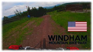
Batavia Skill (designation: Blue Square [Intermediate]) is a Gravity Logic designed-and-built trail that features a single-track feel. This trail is narrow and includes switchbacks, rock features, and wooded sections. Batavia Skill crosses in and out of the Whataride Glades area, and then shoots down into the trees between Lower Wipeout and Wonderama. After flowing out of the trees next to the Assembly Line, this trail finishes through the trees below the ‘B’ Lift Loading area.

Trail Supporters

Bike Park

Traditionally Indigenous Territory

Recent Activity on Trail

Past Week
  • 0 rides
  •  
6 Months
  • 0 rides
  •  
All
  • 147 rides
  • Last: Jun 11, 2017
c1c2c3c4
January
February
March
April
May
June
July
August
September
October
November
December
update trails status or condition

Batavia Skill Trail Reports

Status:
on Apr 3, 2024
Avg: 4.07 (7 votes)
Your vote: 0

view (2,609)
close
3D
Trail Conditions
  • Unknown
  • Snow Groomed
  • Snow Packed
  • Snow Covered
  • Snow Cover Partial
  • Freeze/thaw Cycle
  • Icy
  • Prevalent Mud
  • Wet
  • Variable
  • Ideal
  • Dry
  • Very Dry
Trail Flow (Ridden Direction)
Trailforks scans users ridelogs to determine the most popular direction each trail is ridden. A good flowing trail network will have most trails flowing in a single direction according to their intension.
The colour categories are based on what percentage of riders are riding a trail in its intended direction.
  • > 96%
  • > 90%
  • > 80%
  • > 70%
  • > 50%
  • < 50%
  • bi-directional trail
  • no data
Trail Last Ridden
Trailforks scans ridelogs to determine the last time a trail was ridden.
  • < 2 days
  • < 1 week
  • < 2 weeks
  • < 1 month
  • < 6 months
  • > 6 months
Trail Ridden Direction
The intended direction a trail should be ridden.
  • Downhill Only
  • Downhill Primary
  • Both Directions
  • Uphill Primary
  • Uphill Only
  • One Direction
Contribute Details
Colors indicate trail is missing specified detail.
  • Description
  • Photos
  • Description & Photos
  • Videos
Trail Popularity ?
Trailforks scans ridelogs to determine which trails are ridden the most in the last 9 months. Trails are compared with nearby trails in the same city region with a possible 25 colour shades. Think of this as a heatmap, more rides = more kinetic energy = warmer colors.
  • most popular
  • popular
  • less popular
  • not popular
ATV/ORV/OHV Filter
Max Vehicle Width
inches
US Cell Coverage
Legend
cell carrier legend

Radar Time
Activity Recordings
Trailforks uses anonymized public activity data. ?
Activity Recordings
Trailforks uses anonymized public activity data. ?
Personal Heatmap
Activity Types
all / none
Options
2
Date range month
Winter Trails
Warning A routing network for winter maps does not exist. Selecting trails using the winter trails layer has been disabled.
Missing Trails
Most Popular
Least Popular
Trails are colored based on popularity. The more popular a trail is, the more red. Less popular trails trend towards green.
Jump Magnitude Heatmap
Heatmap of where riders jump on trails. Zoom in to see individual jumps, click circles to view jump details.
BC Backroad Status

Service Road Atlas is a free to use, community-driven service for viewing and creating reports on the numerous back-country service roads around B.C. and Alberta.

map legend
Slope Aspect
Direction the slope faces
Flat N NE E SE S SW W NW
Trails Deemphasized
Trails are shown in grey.
disable
Only show trails with no bike usage.
Enable
Suggested Layers
Based on selected activity type

    Save the current map location and zoom level as your default home location whenever this page is loaded.

    Save
        Directions to batavia-skill trailhead (42.284620, -74.264170)

        Photos

        No photos have been added for Batavia Skill yet, add a photo.

        Videos

        6 more »
        youtuber R.I.P Windham Bike Park USA
        33:23 | 178 | Oct 21, 2023 , Windham
        Batavia Skill [4K] @ Windham Bike Park -...
        12:23 | 541 | Sep 15, 2020 , Windham
        Crash at Windham Mountain
        0:11 | 146 | Jun 9, 2021 , Windham
        batavia berms i
        0:17 | 104 | Sep 23, 2020 , Windham

        Reviews / Comments

        No reviews yet, be the first to write a review or ask a question.
        Use trail reports to comment on trail conditions.


        We hope you've been enjoying Trailforks!

        Create a FREE account to view trail comments and much more.

        • By droppindown & contributors
        • #32425 - 2,558 views

        Frequently Asked Questions About Batavia Skill

        Where is Batavia Skill located?
        Batavia Skill is located in Windham Mountain Bike Park, Windham, New York, United States. It is part of the Windham Mountain Bike Park trail network. The trailhead is located at coordinates 42.28462, -74.26417.
        How hard is Batavia Skill?
        Batavia Skill is rated as Blue difficulty. The average grade is 8.796%.
        What is the elevation gain for Batavia Skill?
        Batavia Skill has 132 ft of elevation gain. The trail has 1,463 ft of elevation descent. The elevation ranges from 1,705 ft to 3,040 ft.
        Is Batavia Skill a point to point trail?
        Batavia Skill is not a point to point trail. The direction is Downhill Primary. The trail type is singletrack.

        Hit the Trail

        Open in App

        Get this trail on your phone instantly.
        open trail in app

        Download Trail

        Save to wishlist, Garmin & download.
        save the trail

        Find Related Routes

        Find routes and users activities that include this trail.
        find routes for this trail

        You must enter a description before submitting.