more stats
1.4 miles
Distance
83 ft
Climb
-746 ft
Descent
00:12:34
Avg time
-664 ft
Altitude change
1,804 ft
Altitude min
2,469 ft
Altitude max
2,468 ft
Altitude start
1,804 ft
Altitude end
-9.1%
Grade
-44.4%
Grade max
25.1%
Grade min
961 ft
Distance climb
1 mile
Distance down
850 ft
Distance flat
00:12:34
Avg time

Baywatch-Upper Details

  • Activities
    • Mountain Bike
    • E-Bike
  • Riding Area
  • Difficulty Rating
  • Local Popularity
    95 in Mountain Biking [+]
    • 100 in E-Biking
  • Global Ranking
    #27953 in Mountain Biking [+]
    • #3247 in E-Biking
  • Trail Type
    Singletrack
  • Bike Type
    DH, AM, XC, CX
  • Direction
    Downhill Only
    Popular Direction Shown
  • Trail Visibility
    Always easy to follow
  • eBike Allowed
    Yes up to Class 1
  • TTFs on Trail
    Berm, Drop, Jump
  • Year Opened
    2019

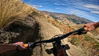
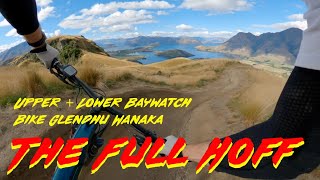
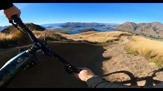
Flow trail that the starts at Falcon's Nest, the summit of Bike Glendhu where you'll find that iconic view.

3.5km of flow down to Jack's Spot when combined with Baywatch-Lower and over 6km back to Base 334 (where the trails begin and end).

Mainly intermediate flow trail with a couple of advanced dropping corners

Part of the Motatapu Blue loop

Access Info

Follow Motatapu Blue Loop
Privately owned bike park. Get passes on site or at https://bikeglendhu.co.nz/

Traditionally Indigenous Territory

Recent Activity on Trail

Past Week
  • 0 rides
  •  
6 Months
  • 73 rides
  • 20 miles avg distance
All
  • 311 rides
  • Last: May 30, 2026
c1c2c3c4
January
February
March
April
May
June
July
August
September
October
November
December
update trails status or condition

Baywatch-Upper Trail Reports

Status:
on Jun 8, 2026
Avg: 4.49 (6 votes)
Your vote: 0

view (4,120)
close
3D
Trail Conditions
  • Unknown
  • Snow Groomed
  • Snow Packed
  • Snow Covered
  • Snow Cover Partial
  • Freeze/thaw Cycle
  • Icy
  • Prevalent Mud
  • Wet
  • Variable
  • Ideal
  • Dry
  • Very Dry
Trail Flow (Ridden Direction)
Trailforks scans users ridelogs to determine the most popular direction each trail is ridden. A good flowing trail network will have most trails flowing in a single direction according to their intension.
The colour categories are based on what percentage of riders are riding a trail in its intended direction.
  • > 96%
  • > 90%
  • > 80%
  • > 70%
  • > 50%
  • < 50%
  • bi-directional trail
  • no data
Trail Last Ridden
Trailforks scans ridelogs to determine the last time a trail was ridden.
  • < 2 days
  • < 1 week
  • < 2 weeks
  • < 1 month
  • < 6 months
  • > 6 months
Trail Ridden Direction
The intended direction a trail should be ridden.
  • Downhill Only
  • Downhill Primary
  • Both Directions
  • Uphill Primary
  • Uphill Only
  • One Direction
Contribute Details
Colors indicate trail is missing specified detail.
  • Description
  • Photos
  • Description & Photos
  • Videos
Trail Popularity ?
Trailforks scans ridelogs to determine which trails are ridden the most in the last 9 months. Trails are compared with nearby trails in the same city region with a possible 25 colour shades. Think of this as a heatmap, more rides = more kinetic energy = warmer colors.
  • most popular
  • popular
  • less popular
  • not popular
ATV/ORV/OHV Filter
Max Vehicle Width
inches
US Cell Coverage
Legend
cell carrier legend

Radar Time
Activity Recordings
Trailforks uses anonymized public activity data. ?
Activity Recordings
Trailforks uses anonymized public activity data. ?
Personal Heatmap
Activity Types
all / none
Options
2
Date range month
Winter Trails
Warning A routing network for winter maps does not exist. Selecting trails using the winter trails layer has been disabled.
Missing Trails
Most Popular
Least Popular
Trails are colored based on popularity. The more popular a trail is, the more red. Less popular trails trend towards green.
Jump Magnitude Heatmap
Heatmap of where riders jump on trails. Zoom in to see individual jumps, click circles to view jump details.
BC Backroad Status

Service Road Atlas is a free to use, community-driven service for viewing and creating reports on the numerous back-country service roads around B.C. and Alberta.

map legend
Slope Aspect
Direction the slope faces
Flat N NE E SE S SW W NW
Trails Deemphasized
Trails are shown in grey.
disable
Only show trails with no bike usage.
Enable
Suggested Layers
Based on selected activity type

    Save the current map location and zoom level as your default home location whenever this page is loaded.

    Save
        Directions to baywatchupper trailhead (-44.670980, 168.971700)

        Photos

        20 more »
        265 |
        Feb 7, 2025 @ 10:21am
        Feb 7, 2025
        757 |
        Jan 6, 2021 @ 3:35pm
        Jan 6, 2021
        114 |
        Feb 10, 2025 @ 9:56am
        Feb 10, 2025
        174 |
        Feb 7, 2025 @ 10:21am
        Feb 7, 2025

        Videos

        6 more »
        youtuber Upper Baywatch @ Bike Glendu. Wanaka
        3:44 | 79 | Jan 19, 2026 , Wānaka
        Breathtaking MTB Scenery! Bike Glendhu Wanaka...
        16:07 | 84 | May 11, 2025 , Wānaka
        YouTube
        8:02 | 222 | Mar 17, 2023 , Wānaka
        youtuber Scenic ASF MTB. Glendhu Bike Park
        8:53 | 202 | May 12, 2022 , Wānaka

        Routes with this trail

        1.0 20 miles 3,310 ft 17 Loop
        2022 Whyte Glendu Enduro 5 Stage

        1 Review & Comments


        We hope you've been enjoying Trailforks!

        Create a FREE account to view trail comments and much more.

        • By bikeglendhubikeparkTF Pro & contributors
        • #242654 - 2,572 views

        Frequently Asked Questions About Baywatch-Upper

        Where is Baywatch-Upper located?
        Baywatch-Upper is located in Bike Glendhu Bike Park, Wānaka, New Zealand. It is part of the Bike Glendhu Bike Park trail network. The trailhead is located at coordinates -44.67098, 168.9717.
        How hard is Baywatch-Upper?
        Baywatch-Upper is rated as Advanced difficulty. The average grade is 9.1%.
        What is the elevation gain for Baywatch-Upper?
        Baywatch-Upper has 25 m of elevation gain. The trail has 228 m of elevation descent. The elevation ranges from 550 m to 753 m.
        Is Baywatch-Upper a point to point trail?
        Yes, Baywatch-Upper is a point to point trail. The direction is Downhill Only. The trail type is singletrack.

        Hit the Trail

        Open in App

        Get this trail on your phone instantly.
        open trail in app

        Download Trail

        Save to wishlist, Garmin & download.
        save the trail

        Find Related Routes

        Find routes and users activities that include this trail.
        find routes for this trail

        You must enter a description before submitting.