more stats
1.1 miles
Distance
5 ft
Climb
-871 ft
Descent
00:08:05
Avg time
-865 ft
Altitude change
4,232 ft
Altitude min
5,104 ft
Altitude max
5,099 ft
Altitude start
4,232 ft
Altitude end
-15.5%
Grade
-42.2%
Grade max
5.2%
Grade min
72 ft
Distance climb
1 mile
Distance down
203 ft
Distance flat
00:08:05
Avg time

Bazooka Joe Details

  • Activities
    • Mountain Bike
    • E-Bike
  • Riding Area
    Panorama Mountain Resort
    Panorama, British Columbia
  • Difficulty Rating
  • Voted Difficulty
    Black Diamond (3 votes)
  • Local Popularity
    90 in Mountain Biking [+]
    • 75 in E-Biking
  • Global Ranking
    #48286 in Mountain Biking [+]
    • #61195 in E-Biking
  • Trail Type
    Singletrack
  • Bike Type
    DH
  • Direction
    Downhill Only
    Popular Direction Shown
  • eBike Allowed
    Yes up to Class 1
  • Land Owner

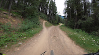
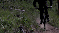
Older technical trail which starts with roots and corners in the trees, both flat and bermed. After merging with Stiffy the trail becomes rocky and technical but can be ridden with some flow once you find the good lines. This is Panorama's hardest blue trail so it is recommended that intermediate riders become confident with the other blue trails first.

Bike Park

Recent Activity on Trail

Past Week
  • 0 rides
  •  
6 Months
  • 0 rides
  •  
All
  • 141 rides
  • Last: Sep 8, 2025
c1c2c3c4
January
February
March
April
May
June
July
August
September
October
November
December
update trails status or condition

Bazooka Joe Trail Reports

Status:
on May 20, 2026
Avg: 4.07 (21 votes)
Your vote: 0

view (1,617)
close
3D
Trail Conditions
  • Unknown
  • Snow Groomed
  • Snow Packed
  • Snow Covered
  • Snow Cover Partial
  • Freeze/thaw Cycle
  • Icy
  • Prevalent Mud
  • Wet
  • Variable
  • Ideal
  • Dry
  • Very Dry
Trail Flow (Ridden Direction)
Trailforks scans users ridelogs to determine the most popular direction each trail is ridden. A good flowing trail network will have most trails flowing in a single direction according to their intension.
The colour categories are based on what percentage of riders are riding a trail in its intended direction.
  • > 96%
  • > 90%
  • > 80%
  • > 70%
  • > 50%
  • < 50%
  • bi-directional trail
  • no data
Trail Last Ridden
Trailforks scans ridelogs to determine the last time a trail was ridden.
  • < 2 days
  • < 1 week
  • < 2 weeks
  • < 1 month
  • < 6 months
  • > 6 months
Trail Ridden Direction
The intended direction a trail should be ridden.
  • Downhill Only
  • Downhill Primary
  • Both Directions
  • Uphill Primary
  • Uphill Only
  • One Direction
Contribute Details
Colors indicate trail is missing specified detail.
  • Description
  • Photos
  • Description & Photos
  • Videos
Trail Popularity ?
Trailforks scans ridelogs to determine which trails are ridden the most in the last 9 months. Trails are compared with nearby trails in the same city region with a possible 25 colour shades. Think of this as a heatmap, more rides = more kinetic energy = warmer colors.
  • most popular
  • popular
  • less popular
  • not popular
ATV/ORV/OHV Filter
Max Vehicle Width
inches
US Cell Coverage
Legend
cell carrier legend

Radar Time
Activity Recordings
Trailforks uses anonymized public activity data. ?
Activity Recordings
Trailforks uses anonymized public activity data. ?
Personal Heatmap
Activity Types
all / none
Options
2
Date range month
Winter Trails
Warning A routing network for winter maps does not exist. Selecting trails using the winter trails layer has been disabled.
Missing Trails
Most Popular
Least Popular
Trails are colored based on popularity. The more popular a trail is, the more red. Less popular trails trend towards green.
Jump Magnitude Heatmap
Heatmap of where riders jump on trails. Zoom in to see individual jumps, click circles to view jump details.
BC Backroad Status

Service Road Atlas is a free to use, community-driven service for viewing and creating reports on the numerous back-country service roads around B.C. and Alberta.

map legend
Slope Aspect
Direction the slope faces
Flat N NE E SE S SW W NW
Trails Deemphasized
Trails are shown in grey.
disable
Only show trails with no bike usage.
Enable
Suggested Layers
Based on selected activity type

    Save the current map location and zoom level as your default home location whenever this page is loaded.

    Save
        Directions to bazooka-joe trailhead (50.444530, -116.231430)

        Photos

        24 more »
        200 |
        Jun 23, 2021 @ 2:58pm
        Jun 23, 2021
        323 |
        Jul 11, 2020 @ 8:14am
        Jul 11, 2020
        104 |
        Jul 1, 2020 @ 2:49pm
        Jul 1, 2020
        107 |
        Jul 1, 2020 @ 2:48pm
        Jul 1, 2020

        Videos

        10 more »
        Bazooka Joe / Panorama, BC
        8:01 | 222 | Sep 12, 2023 , Panorama
        I Ride A DH Course (By Accident) | Panorama Part 2
        18:32 | 451 | Oct 12, 2019 , Panorama
        Stiffy to Bazooka Joe Panorama Bike Park
        3:54 | 90 | Aug 14, 2022 , Panorama
        MVP
        0:04 | 461 | Oct 7, 2015 , Panorama

        Routes with this trail

        14 miles 4,343 ft 11 Race
        Boobs on Tubes enduro 2025 route
        4.7 12 miles 4,182 ft 11 Race
        Enduro route 3 option, if ready
        10 miles 3,807 ft 9 Race
        OKTimes Funduro Information: You don’t have to be the best of the best to get in on the action for this...

        Reviews / Comments

        No reviews yet, be the first to write a review or ask a question.
        Use trail reports to comment on trail conditions.


        We hope you've been enjoying Trailforks!

        Create a FREE account to view trail comments and much more.

        • By Tekmisfit & contributors
        • #2453 - 6,275 views

        Frequently Asked Questions About Bazooka Joe

        Where is Bazooka Joe located?
        Bazooka Joe is located in Panorama Mountain Resort, Panorama, British Columbia, Canada. It is part of the Panorama Mountain Resort trail network. The trailhead is located at coordinates 50.44453, -116.23143.
        How hard is Bazooka Joe?
        Bazooka Joe is rated as Blue difficulty. The average grade is 15.5%.
        What is the elevation gain for Bazooka Joe?
        Bazooka Joe has 1 m of elevation gain. The trail has 266 m of elevation descent. The elevation ranges from 1,290 m to 1,556 m.
        Is Bazooka Joe a point to point trail?
        Yes, Bazooka Joe is a point to point trail. The direction is Downhill Only. The trail type is singletrack.

        Hit the Trail

        Open in App

        Get this trail on your phone instantly.
        open trail in app

        Download Trail

        Save to wishlist, Garmin & download.
        save the trail

        Find Related Routes

        Find routes and users activities that include this trail.
        find routes for this trail

        You must enter a description before submitting.