more stats
1.5 miles
Distance
73 ft
Climb
-830 ft
Descent
00:19:23
Avg time
-757 ft
Altitude change
2,962 ft
Altitude min
3,758 ft
Altitude max
3,719 ft
Altitude start
2,963 ft
Altitude end
-9.3%
Grade
-50.2%
Grade max
11.3%
Grade min
1,460 ft
Distance climb
1 mile
Distance down
417 ft
Distance flat
00:19:23
Avg time

Be Kind Details

  • Activities
    • Mountain Bike
    • E-Bike
    • Hike
    • Trail Running
  • Riding Area
    Kalamalka Lake
    Vernon, British Columbia
  • Difficulty Rating
  • Local Popularity
    95 in Mountain Biking [+]
    • 95 in E-Biking
    • 60 in Trail Running
    • 60 in Hiking
  • Global Ranking
    #27351 in Mountain Biking [+]
    • #2199 in E-Biking
    • #51146 in Trail Running
    • #120997 in Hiking
  • Trail Type
    Singletrack
  • Bike Type
    AM, XC
  • Climb Difficulty
    Blue
  • Physical Rating
    Moderate
  • Trail Visibility
    Always easy to follow
  • Dogs Allowed
    Yes
  • eBike Allowed
  • TTFs on Trail
    Berm, Bridge, Drop, Jump, Rock Face, Rock Garden, Wallride
  • Year Opened
    2020

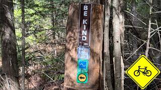
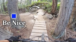
New tech flow dark blue trail from Paligap to Rotten Cabin and then leads into Flovid , a blue flow trail to HRT near 36 DD / Twista. Be Kind is now officially open as of October 2020 This trail is Kal Parks newest tech trail that is on the dark blue end of things. Some awesome side hits to keep everyone entertained mixed with fun tech along the whole way!

Access Info

Either shuttle to the top and ride down Pali Gap or pedal up Stone Free, Stoned Again, and Pali Gap until you find the start of trail.

Trail Supporters
  • Contour Trails
    2020 - 2021
    Builder
Local Trail Association

Recent Activity on Trail

Past Week
  • 1 rides
  • 19 miles average
6 Months
  • 97 rides
  • 13 miles avg distance
All
  • 868 rides
  • Last: Jun 27, 2026
c1c2c3c4
January
February
March
April
May
June
July
August
September
October
November
December
update trails status or condition

Be Kind Trail Reports

statusdatedescription
May 27, 2026 @ 4:44am (America/Los_Angeles)
May 27, 2026
reporter Cleared all the blow down May 15th
May 10, 2026 @ 11:41am (America/Vancouver)
May 10, 2026
Large tree down across trail, blocking trail
May 6, 2026 @ 5:37pm (America/Creston)
May 6, 2026
Tree down. Power saw needed. Check out this location: Tree Down on BK at coordinates 50.184650, -119.232716.
May 1, 2026 @ 1:10pm (America/Vancouver)
May 1, 2026
two trees down
Apr 26, 2026 @ 1:42pm (America/Vancouver)
Apr 26, 2026
Tree x 2 down
more »
Status:
on May 27, 2026
Ideal
Avg: 4.38 (15 votes)
Your vote: 0

view (4,795)
close
3D
Trail Conditions
  • Unknown
  • Snow Groomed
  • Snow Packed
  • Snow Covered
  • Snow Cover Partial
  • Freeze/thaw Cycle
  • Icy
  • Prevalent Mud
  • Wet
  • Variable
  • Ideal
  • Dry
  • Very Dry
Trail Flow (Ridden Direction)
Trailforks scans users ridelogs to determine the most popular direction each trail is ridden. A good flowing trail network will have most trails flowing in a single direction according to their intension.
The colour categories are based on what percentage of riders are riding a trail in its intended direction.
  • > 96%
  • > 90%
  • > 80%
  • > 70%
  • > 50%
  • < 50%
  • bi-directional trail
  • no data
Trail Last Ridden
Trailforks scans ridelogs to determine the last time a trail was ridden.
  • < 2 days
  • < 1 week
  • < 2 weeks
  • < 1 month
  • < 6 months
  • > 6 months
Trail Ridden Direction
The intended direction a trail should be ridden.
  • Downhill Only
  • Downhill Primary
  • Both Directions
  • Uphill Primary
  • Uphill Only
  • One Direction
Contribute Details
Colors indicate trail is missing specified detail.
  • Description
  • Photos
  • Description & Photos
  • Videos
Trail Popularity ?
Trailforks scans ridelogs to determine which trails are ridden the most in the last 9 months. Trails are compared with nearby trails in the same city region with a possible 25 colour shades. Think of this as a heatmap, more rides = more kinetic energy = warmer colors.
  • most popular
  • popular
  • less popular
  • not popular
ATV/ORV/OHV Filter
Max Vehicle Width
inches
US Cell Coverage
Legend
cell carrier legend

Radar Time
Activity Recordings
Trailforks uses anonymized public activity data. ?
Activity Recordings
Trailforks uses anonymized public activity data. ?
Personal Heatmap
Activity Types
all / none
Options
2
Date range month
Winter Trails
Warning A routing network for winter maps does not exist. Selecting trails using the winter trails layer has been disabled.
Missing Trails
Most Popular
Least Popular
Trails are colored based on popularity. The more popular a trail is, the more red. Less popular trails trend towards green.
Jump Magnitude Heatmap
Heatmap of where riders jump on trails. Zoom in to see individual jumps, click circles to view jump details.
BC Backroad Status

Service Road Atlas is a free to use, community-driven service for viewing and creating reports on the numerous back-country service roads around B.C. and Alberta.

map legend
Slope Aspect
Direction the slope faces
Flat N NE E SE S SW W NW
Trails Deemphasized
Trails are shown in grey.
disable
Only show trails with no bike usage.
Enable
Suggested Layers
Based on selected activity type

    Save the current map location and zoom level as your default home location whenever this page is loaded.

    Save
        Directions to be-kind trailhead (50.177070, -119.241100)

        Photos

        33 more »
        150 |
        Jun 25, 2023 @ 4:23pm
        Jun 25, 2023
        276 |
        Aug 27, 2022 @ 9:51pm
        Aug 27, 2022
        209 |
        Sep 4, 2021 @ 10:41pm
        Sep 4, 2021
        342 |
        Oct 15, 2020 @ 2:40pm
        Oct 15, 2020

        Videos

        5 more »
        Riding Be Kind in Vernon B.C. | Flowy but...
        7:32 | 34 | Apr 19, 2026 , Vernon
        40ft slab on new rake and ride trail
        13:20 | 217 | Apr 20, 2024 , Vernon
        Be Nice - Kalamalka Mtn
        10:06 | 253 | Jul 16, 2023 , Vernon
        youtuber Be Kind - Okanagan Mountain Biking
        6:52 | 368 | May 31, 2023 , Vernon

        Routes with this trail

        4.0 30 miles 6,043 ft 16 Loop
        Big views, big climbs and an extended 14 km single-track (almost) continuous descent from the high point,...
        5.0 30 miles 6,421 ft 18 Loop
        This is an alternate to the original Killer King route to reflect new trails on the King Eddie Plateau....
        10 miles 2,448 ft 6
        This Week is the classic loop! we are focusing on one big route this week. Head up and enjoy a great mix...

        12 Reviews & Comments


        We hope you've been enjoying Trailforks!

        Create a FREE account to view trail comments and much more.

        • By markeedTF Pro NOCS & contributors
        • #44449 - 10,202 views

        Frequently Asked Questions About Be Kind

        Where is Be Kind located?
        Be Kind is located in Kalamalka Lake, Vernon, British Columbia, Canada. It is part of the Kalamalka Lake trail network. The trailhead is located at coordinates 50.17707, -119.2411.
        How hard is Be Kind?
        Be Kind is rated as Blue difficulty. The physical rating is Moderate. The average grade is 9.3%. The climb difficulty is rated Blue.
        What is the elevation gain for Be Kind?
        Be Kind has 22 m of elevation gain. The trail has 253 m of elevation descent. The elevation ranges from 903 m to 1,145 m.
        How long is Be Kind?
        Be Kind is 2.5 km long. The trail type is singletrack.

        Hit the Trail

        Open in App

        Get this trail on your phone instantly.
        open trail in app

        Download Trail

        Save to wishlist, Garmin & download.
        save the trail

        Find Related Routes

        Find routes and users activities that include this trail.
        find routes for this trail

        You must enter a description before submitting.