more stats
4,229 ft
Distance
60 ft
Climb
-72 ft
Descent
00:09:05
Avg time
-11 ft
Altitude change
2,499 ft
Altitude min
2,559 ft
Altitude max
2,510 ft
Altitude start
2,500 ft
Altitude end
-0.3%
Grade
-12.7%
Grade max
9.9%
Grade min
1,867 ft
Distance climb
1,854 ft
Distance down
505 ft
Distance flat
00:09:05
Avg time

Bear Details

  • Activities
    • Mountain Bike
    • E-Bike
    • Hike
    • Trail Running
  • Riding Area
    Three Blind Mice
    Penticton, British Columbia
  • Difficulty Rating
  • Local Popularity
    60 in Mountain Biking [+]
    • 80 in E-Biking
    • 70 in Trail Running
    • 5 in Hiking
  • Global Ranking
    #98419 in Mountain Biking [+]
    • #41951 in E-Biking
    • #87452 in Trail Running
    • #249428 in Hiking
  • Trail Type
    Singletrack
  • Bike Type
    AM, XC
  • Climb Difficulty
    Blue
  • Physical Rating
    Moderate
  • Season
    April-November
  • Dogs Allowed
    Yes
  • eBike Allowed
    Yes up to Class 1

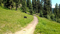
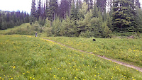
A pleasant little pedal in the middle of nowhere. If you are climbing (heading north), you will spill out on a 2-track. Follow this down and left and you will stumble upon Slabs. If the rocks of Slabs aren't your thing, follow the 2-track (Turnbull Creek Trail) down until Fred.

Access Info

While descending Black Bear, you will be 'finishing' on some rock slab 'steps' and the trail will turn to soils. There is a tree just to your right immediately before you spill into a gully. This is the south tip of Bear.

Local Trail Association

Recent Activity on Trail

Past Week
  • 0 rides
  •  
6 Months
  • 5 rides
  • 11 miles avg distance
All
  • 51 rides
  • Last: Jun 18, 2026
c1c2c3c4
January
February
March
April
May
June
July
August
September
October
November
December
update trails status or condition

Bear Trail Reports

statusdatedescription
Nov 8, 2025 @ 3:32pm (America/Vancouver)
Nov 8, 2025
Large tree (approx 50 cm diam) down across trail, blocking trail just below junction with Bear trail. In the "S" bends gully section at the top of...
Jul 18, 2025 @ 9:29am
Jul 18, 2025
May 31, 2025 @ 9:19am
May 31, 2025
reporter
Apr 12, 2025 @ 1:34pm
Apr 12, 2025
Apr 12, 2025 @ 1:33pm
Apr 12, 2025
more »
Status:
on Nov 8, 2025
Avg: 3.54 (5 votes)
Your vote: 0

view (457)
close
3D
Trail Conditions
  • Unknown
  • Snow Groomed
  • Snow Packed
  • Snow Covered
  • Snow Cover Partial
  • Freeze/thaw Cycle
  • Icy
  • Prevalent Mud
  • Wet
  • Variable
  • Ideal
  • Dry
  • Very Dry
Trail Flow (Ridden Direction)
Trailforks scans users ridelogs to determine the most popular direction each trail is ridden. A good flowing trail network will have most trails flowing in a single direction according to their intension.
The colour categories are based on what percentage of riders are riding a trail in its intended direction.
  • > 96%
  • > 90%
  • > 80%
  • > 70%
  • > 50%
  • < 50%
  • bi-directional trail
  • no data
Trail Last Ridden
Trailforks scans ridelogs to determine the last time a trail was ridden.
  • < 2 days
  • < 1 week
  • < 2 weeks
  • < 1 month
  • < 6 months
  • > 6 months
Trail Ridden Direction
The intended direction a trail should be ridden.
  • Downhill Only
  • Downhill Primary
  • Both Directions
  • Uphill Primary
  • Uphill Only
  • One Direction
Contribute Details
Colors indicate trail is missing specified detail.
  • Description
  • Photos
  • Description & Photos
  • Videos
Trail Popularity ?
Trailforks scans ridelogs to determine which trails are ridden the most in the last 9 months. Trails are compared with nearby trails in the same city region with a possible 25 colour shades. Think of this as a heatmap, more rides = more kinetic energy = warmer colors.
  • most popular
  • popular
  • less popular
  • not popular
ATV/ORV/OHV Filter
Max Vehicle Width
inches
US Cell Coverage
Legend
cell carrier legend

Radar Time
Activity Recordings
Trailforks uses anonymized public activity data. ?
Activity Recordings
Trailforks uses anonymized public activity data. ?
Personal Heatmap
Activity Types
all / none
Options
2
Date range month
Winter Trails
Warning A routing network for winter maps does not exist. Selecting trails using the winter trails layer has been disabled.
Missing Trails
Most Popular
Least Popular
Trails are colored based on popularity. The more popular a trail is, the more red. Less popular trails trend towards green.
Jump Magnitude Heatmap
Heatmap of where riders jump on trails. Zoom in to see individual jumps, click circles to view jump details.
BC Backroad Status

Service Road Atlas is a free to use, community-driven service for viewing and creating reports on the numerous back-country service roads around B.C. and Alberta.

map legend
Slope Aspect
Direction the slope faces
Flat N NE E SE S SW W NW
Trails Deemphasized
Trails are shown in grey.
disable
Only show trails with no bike usage.
Enable
Suggested Layers
Based on selected activity type

    Save the current map location and zoom level as your default home location whenever this page is loaded.

    Save
        Directions to bear-41879 trailhead (49.545680, -119.546250)

        Photos

        16 more »
        240 |
        Jul 20, 2011 @ 9:19am
        Jul 20, 2011
        1,048 |
        Jul 24, 2011 @ 2:00am
        Jul 24, 2011
        474 |
        Jul 24, 2011 @ 2:00am
        Jul 24, 2011
        1,585 |
        Mar 20, 2012 @ 10:19pm
        Mar 20, 2012

        Videos

        4 more »
        Riding with the Sun Peaks Bears
        0:36 | 13 | Jul 8, 2014 , Penticton
        Riding with the Sun Peaks Bears
        0:15 | 8 | Jul 8, 2014 , Penticton
        sunpeaks.
        0:36 | 601 | Aug 2, 2009 , Penticton
        The Bear
        0:34 | 292 | Sep 16, 2012 , Penticton

        Routes with this trail

        11 miles 1,069 ft 10
        Three Blind Mice is big enough for two official Backyard Ride Guide's, so that's exactly what it gets!...
        1.0 15 miles 2,565 ft 8
        MegaVolt eFondo is meant to test the rider and the bike in an overland style race without strong focus on...
        29 miles 5,221 ft 14
        draft route starting and finishing in Naramata

        Trail Products

        Reviews / Comments

        No reviews yet, be the first to write a review or ask a question.
        Use trail reports to comment on trail conditions.


        We hope you've been enjoying Trailforks!

        Create a FREE account to view trail comments and much more.

        • By 1partatatimeTF Pro PACA & contributors
        • #41879 - 2,062 views

        Frequently Asked Questions About Bear

        Where is Bear located?
        Bear is located in Three Blind Mice, Penticton, British Columbia, Canada. It is part of the Three Blind Mice trail network. The trailhead is located at coordinates 49.54568, -119.54625.
        How hard is Bear?
        Bear is rated as Green difficulty. The physical rating is Moderate. The average grade is 0.3%. The climb difficulty is rated Blue.
        What is the elevation gain for Bear?
        Bear has 60 ft of elevation gain. The trail has 72 ft of elevation descent. The elevation ranges from 2,499 ft to 2,559 ft.
        How long is Bear?
        Bear is 4,229 ft long. The trail type is singletrack.

        Hit the Trail

        Open in App

        Get this trail on your phone instantly.
        open trail in app

        Download Trail

        Save to wishlist, Garmin & download.
        save the trail

        Find Related Routes

        Find routes and users activities that include this trail.
        find routes for this trail

        You must enter a description before submitting.