more stats
2.2 miles
Distance
702 ft
Climb
-350 ft
Descent
00:32:26
Avg time
351 ft
Altitude change
2,632 ft
Altitude min
3,073 ft
Altitude max
2,632 ft
Altitude start
2,982 ft
Altitude end
3%
Grade
-32.3%
Grade max
53.3%
Grade min
1 mile
Distance climb
3,517 ft
Distance down
860 ft
Distance flat
00:32:26
Avg time

Beeched As Details

  • Activities
    • Mountain Bike
    • E-Bike
    • Trail Running
  • Riding Area
    Fernhill Trails
    Queenstown
  • Difficulty Rating
  • Local Popularity
    90 in Mountain Biking [+]
    • 80 in E-Biking
    • 45 in Trail Running
  • Global Ranking
    #24430 in Mountain Biking [+]
    • #31989 in E-Biking
    • #111038 in Trail Running
  • Hiking SAC Scale
    T3 Demanding Mountain Hiking
  • Trail Type
    Singletrack
  • Bike Type
    AM, XC
  • Physical Rating
    Hard
  • Trail Visibility
    Always easy to follow
  • Season
    Sept-May
  • Alpine Trail
    Yes
  • Dogs Allowed
    Yes
  • eBike Allowed
    Yes up to Class 1
  • TTFs on Trail
    Berm, Bridge, Rock Garden
  • Year Opened
    2015
  • Land Owner
    DOC

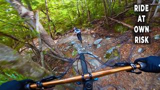
Hand built singletrack through the Beech Forest on Ben Lomond. Some exposed drops off the side of the trail and quite narrow in places.

Access Info

Ride up Skyline Access Road (or take Gondola) ride up past the luge chairlift and take a right just past the top building up steep 4WD track Turn left onto Ben Lomond trail. 10 or 15m in take the left fork on the single track to avoid riding on the walking trail. Don't take any other forks until you are out in the open again at the original start.

Remember the Ben Lomond trail is primarily a walking track so be nice to walkers

Local Trail Association
Traditionally Indigenous Territory

Recent Activity on Trail

Past Week
  • 2 rides
  • 10 miles average
6 Months
  • 65 rides
  • 16 miles avg distance
All
  • 235 rides
  • Last: Jun 19, 2026
c1c2c3c4
January
February
March
April
May
June
July
August
September
October
November
December
update trails status or condition

Beeched As Trail Reports

statusdatedescription
Jan 14, 2026 @ 4:11pm (Pacific/Auckland)
Jan 13, 2026
Tree cleared after creeky entrance.
Jan 12, 2026 @ 10:06am (Pacific/Auckland)
Jan 11, 2026
Tree down but after creeky. Borderline e saw
Dec 19, 2025 @ 2:54pm (Pacific/Auckland)
Dec 18, 2025
Trees cleared from end of trail
Dec 16, 2025 @ 1:40pm (Pacific/Auckland)
Dec 15, 2025
Tree down at the end of Beeched as, just before exiting the forest, you can divert onto the Fernhill route to get around
Dec 2, 2025 @ 1:33pm (Pacific/Auckland)
Dec 1, 2025
Tree cleared from trail after Creeky winders crossing.
more »
Status:
on Jan 14, 2026
Avg: 4.49 (12 votes)
Your vote: 0

view (3,335)
close
3D
Trail Conditions
  • Unknown
  • Snow Groomed
  • Snow Packed
  • Snow Covered
  • Snow Cover Partial
  • Freeze/thaw Cycle
  • Icy
  • Prevalent Mud
  • Wet
  • Variable
  • Ideal
  • Dry
  • Very Dry
Trail Flow (Ridden Direction)
Trailforks scans users ridelogs to determine the most popular direction each trail is ridden. A good flowing trail network will have most trails flowing in a single direction according to their intension.
The colour categories are based on what percentage of riders are riding a trail in its intended direction.
  • > 96%
  • > 90%
  • > 80%
  • > 70%
  • > 50%
  • < 50%
  • bi-directional trail
  • no data
Trail Last Ridden
Trailforks scans ridelogs to determine the last time a trail was ridden.
  • < 2 days
  • < 1 week
  • < 2 weeks
  • < 1 month
  • < 6 months
  • > 6 months
Trail Ridden Direction
The intended direction a trail should be ridden.
  • Downhill Only
  • Downhill Primary
  • Both Directions
  • Uphill Primary
  • Uphill Only
  • One Direction
Contribute Details
Colors indicate trail is missing specified detail.
  • Description
  • Photos
  • Description & Photos
  • Videos
Trail Popularity ?
Trailforks scans ridelogs to determine which trails are ridden the most in the last 9 months. Trails are compared with nearby trails in the same city region with a possible 25 colour shades. Think of this as a heatmap, more rides = more kinetic energy = warmer colors.
  • most popular
  • popular
  • less popular
  • not popular
ATV/ORV/OHV Filter
Max Vehicle Width
inches
US Cell Coverage
Legend
cell carrier legend

Radar Time
Activity Recordings
Trailforks uses anonymized public activity data. ?
Activity Recordings
Trailforks uses anonymized public activity data. ?
Personal Heatmap
Activity Types
all / none
Options
2
Date range month
Winter Trails
Warning A routing network for winter maps does not exist. Selecting trails using the winter trails layer has been disabled.
Missing Trails
Most Popular
Least Popular
Trails are colored based on popularity. The more popular a trail is, the more red. Less popular trails trend towards green.
Jump Magnitude Heatmap
Heatmap of where riders jump on trails. Zoom in to see individual jumps, click circles to view jump details.
BC Backroad Status

Service Road Atlas is a free to use, community-driven service for viewing and creating reports on the numerous back-country service roads around B.C. and Alberta.

map legend
Slope Aspect
Direction the slope faces
Flat N NE E SE S SW W NW
Trails Deemphasized
Trails are shown in grey.
disable
Only show trails with no bike usage.
Enable
Suggested Layers
Based on selected activity type

    Save the current map location and zoom level as your default home location whenever this page is loaded.

    Save
        Directions to beeched-as trailhead (-45.026730, 168.646660)

        Photos

        119 more »
        44 |
        Apr 26, 2024 @ 11:48am
        Apr 26, 2024
        47 |
        Feb 28, 2023 @ 4:09pm
        Feb 28, 2023
        36 |
        Feb 28, 2023 @ 4:09pm
        Feb 28, 2023
        49 |
        Feb 28, 2023 @ 4:09pm
        Feb 28, 2023

        Videos

        6 more »
        youtuber This trail is ICONIC and Scary | Must Ride
        16:11 | 42 | Apr 8, 2026 , Queenstown
        Queenstown Bikepark - Pitch Black, Gin Trap,...
        16:35 | 70 | May 11, 2025 , Queenstown
        Beeched As Queenstown
        9:03 | 650 | Apr 5, 2020 , Queenstown
        Hidden downhill ridgeline from Ben Lomond...
        20:23 | 1007 | May 17, 2018 , Queenstown

        Routes with this trail

        4.7 7 miles 2,568 ft 4 Point to Point
        An alternative route to utilising as much purpose built singletrac as possible. Allow roughly 3 to 5 hours...
        185 miles 39,064 ft 36
        Starting in Tāhuna , heading on bike path to Frankton ,taking in Remarkables, before returning to bike...
        2.0 17 miles 5,006 ft 9 Loop
        Loop linking some of the best backcountry trails in Fernhill, starting straight from Queenstown

        1 Review & Comments


        We hope you've been enjoying Trailforks!

        Create a FREE account to view trail comments and much more.

        • By BrendhanTF Pro QMTBC & contributors
        • #46270 - 8,698 views

        Frequently Asked Questions About Beeched As

        Where is Beeched As located?
        Beeched As is located in Fernhill Trails, Queenstown, New Zealand. It is part of the Fernhill Trails trail network. The trailhead is located at coordinates -45.02673, 168.64666.
        How hard is Beeched As?
        Beeched As is rated as Advanced difficulty. The physical rating is Hard. The average grade is 3%.
        What is the elevation gain for Beeched As?
        Beeched As has 702 ft of elevation gain. The trail has 350 ft of elevation descent. The elevation ranges from 2,632 ft to 3,073 ft.
        How long is Beeched As?
        Beeched As is 2.2 miles long. The trail type is singletrack.

        Hit the Trail

        Open in App

        Get this trail on your phone instantly.
        open trail in app

        Download Trail

        Save to wishlist, Garmin & download.
        save the trail

        Find Related Routes

        Find routes and users activities that include this trail.
        find routes for this trail

        You must enter a description before submitting.