more stats
3.6 miles
Distance
324 ft
Climb
-231 ft
Descent
00:28:39
Avg time
93 ft
Altitude change
4,169 ft
Altitude min
4,389 ft
Altitude max
4,180 ft
Altitude start
4,272 ft
Altitude end
0.5%
Grade
-23.7%
Grade max
17%
Grade min
2 miles
Distance climb
1 mile
Distance down
2,844 ft
Distance flat
00:28:39
Avg time

Bell Rock Pathway Details

  • Activities
    • Mountain Bike
    • Adaptive Bike
    • Horse
    • Hike
    • Trail Running
  • Riding Area
    Bell Rock
    Village Of Oak Creek, Arizona
  • Difficulty Rating
  • Voted Difficulty
    Green (3 votes)
  • Local Popularity
    65 in Mountain Biking [+]
    • 70 in Trail Running
    • 30 in Hiking
    • 5 in Horseback
  • Global Ranking
    #18399 in Mountain Biking [+]
    • #36947 in Trail Running
    • #102630 in Hiking
    • #233 in Horseback
  • Trail Type
    Singletrack
  • Bike Type
  • Direction
    Both Directions
    Popular In Reverse
  • Dogs Allowed
    Yes
  • eBike Allowed

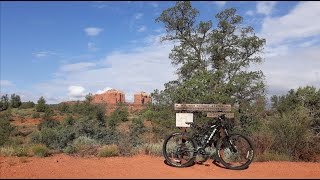
Beginner 95% and intermediate 5%, 3.56 mile MTB trail which is a bi-directional double track that has some up and down character that makes some sections difficult to climb for beginner riders. The trail tread is mainly packed dirt which can be loose during extended dry periods which causes a safety issue for beginners riding too fast for their skill level. There is no preferred direction and the trail is a great connector for several other fun loops.

Adaptive Bike Info
aMTB Green Rating: Beginner features and moderate terrain.
Trail Supporters

  • USFS
    Land Manager
Local Trail Association

Recent Activity on Trail

Past Week
  • 2 rides
  • 9 miles average
6 Months
  • 79 rides
  • 12 miles avg distance
All
  • 841 rides
  • Last: Jun 18, 2026
c1c2c3c4
January
February
March
April
May
June
July
August
September
October
November
December
Status:
on Jan 22, 2026
Dry
Avg: 3.26 (29 votes)
Your vote: 0

view (3,509)
close
3D
Trail Conditions
  • Unknown
  • Snow Groomed
  • Snow Packed
  • Snow Covered
  • Snow Cover Partial
  • Freeze/thaw Cycle
  • Icy
  • Prevalent Mud
  • Wet
  • Variable
  • Ideal
  • Dry
  • Very Dry
Trail Flow (Ridden Direction)
Trailforks scans users ridelogs to determine the most popular direction each trail is ridden. A good flowing trail network will have most trails flowing in a single direction according to their intension.
The colour categories are based on what percentage of riders are riding a trail in its intended direction.
  • > 96%
  • > 90%
  • > 80%
  • > 70%
  • > 50%
  • < 50%
  • bi-directional trail
  • no data
Trail Last Ridden
Trailforks scans ridelogs to determine the last time a trail was ridden.
  • < 2 days
  • < 1 week
  • < 2 weeks
  • < 1 month
  • < 6 months
  • > 6 months
Trail Ridden Direction
The intended direction a trail should be ridden.
  • Downhill Only
  • Downhill Primary
  • Both Directions
  • Uphill Primary
  • Uphill Only
  • One Direction
Contribute Details
Colors indicate trail is missing specified detail.
  • Description
  • Photos
  • Description & Photos
  • Videos
Trail Popularity ?
Trailforks scans ridelogs to determine which trails are ridden the most in the last 9 months. Trails are compared with nearby trails in the same city region with a possible 25 colour shades. Think of this as a heatmap, more rides = more kinetic energy = warmer colors.
  • most popular
  • popular
  • less popular
  • not popular
ATV/ORV/OHV Filter
Max Vehicle Width
inches
US Cell Coverage
Legend
cell carrier legend

Radar Time
Activity Recordings
Trailforks uses anonymized public activity data. ?
Activity Recordings
Trailforks uses anonymized public activity data. ?
Personal Heatmap
Activity Types
all / none
Options
2
Date range month
Winter Trails
Warning A routing network for winter maps does not exist. Selecting trails using the winter trails layer has been disabled.
Missing Trails
Most Popular
Least Popular
Trails are colored based on popularity. The more popular a trail is, the more red. Less popular trails trend towards green.
Jump Magnitude Heatmap
Heatmap of where riders jump on trails. Zoom in to see individual jumps, click circles to view jump details.
BC Backroad Status

Service Road Atlas is a free to use, community-driven service for viewing and creating reports on the numerous back-country service roads around B.C. and Alberta.

map legend
Slope Aspect
Direction the slope faces
Flat N NE E SE S SW W NW
Trails Deemphasized
Trails are shown in grey.
disable
Only show trails with no bike usage.
Enable
Suggested Layers
Based on selected activity type

    Save the current map location and zoom level as your default home location whenever this page is loaded.

    Save
        Directions to bell-rock-pathway trailhead (34.791490, -111.761730)

        Photos

        60 more »
        384 |
        Dec 27, 2017 @ 10:25pm
        Dec 27, 2017
        532 |
        Nov 16, 2014 @ 3:48pm
        Nov 16, 2014
        47 |
        Mar 21, 2024 @ 2:18pm
        Mar 21, 2024
        46 |
        Mar 21, 2024 @ 2:18pm
        Mar 21, 2024

        Videos

        11 more »
        youtuber Bell Rock Pathway - Sedona Patron Ride - Dusty...
        5:03 | 1777 | Mar 19, 2018 , Village Of Oak Creek
        #flashbackfriday Riding in Sedona, AZ✌️
        4:23 | 157 | Jun 21, 2024 , Village Of Oak Creek
        MTB Riding Sedona | Bell Rock Vista Trails |...
        29:39 | 311 | Sep 10, 2022 , Village Of Oak Creek
        MTB Riding Sedona | Bell Rock Vista Trails |...
        18:29 | 262 | Sep 6, 2022 , Village Of Oak Creek

        Routes with this trail

        3.5 10 miles 1,100 ft 14 Loop
        This is another must do ride for the advanced rider. The ride itself is quite technical, very scenic and...
        4.0 9 miles 696 ft 15
        This is a great beginner loop in Sedona. is super mellow and picturesque. is a bit more technical and...
        3.5 13 miles 1,252 ft 27
        Loop to discover the area of Oak Creek with a group of good teenagers. Parking at vista TH and the loop...

        7 Reviews & Comments


        We hope you've been enjoying Trailforks!

        Create a FREE account to view trail comments and much more.

        • By toddTF Pro Trailforks & contributors
        • #14540 - 17,576 views

        Frequently Asked Questions About Bell Rock Pathway

        Where is Bell Rock Pathway located?
        Bell Rock Pathway is located in Bell Rock, Village Of Oak Creek, Arizona, United States. It is part of the Bell Rock trail network. The trailhead is located at coordinates 34.79149, -111.76173.
        How hard is Bell Rock Pathway?
        Bell Rock Pathway is rated as Green difficulty. The average grade is 0.5%.
        What is the elevation gain for Bell Rock Pathway?
        Bell Rock Pathway has 99 m of elevation gain. The trail has 70 m of elevation descent. The elevation ranges from 1,271 m to 1,338 m.
        Is Bell Rock Pathway a point to point trail?
        Bell Rock Pathway is not a point to point trail. The direction is Both Directions. The trail type is singletrack.

        Hit the Trail

        Open in App

        Get this trail on your phone instantly.
        open trail in app

        Download Trail

        Save to wishlist, Garmin & download.
        save the trail

        Find Related Routes

        Find routes and users activities that include this trail.
        find routes for this trail

        You must enter a description before submitting.