more stats
8.7 miles
Distance
1,147 ft
Climb
-1,906 ft
Descent
01:32:26
Avg time
-758 ft
Altitude change
547 ft
Altitude min
1,574 ft
Altitude max
1,305 ft
Altitude start
548 ft
Altitude end
-1.7%
Grade
-51.6%
Grade max
30.1%
Grade min
3 miles
Distance climb
5 miles
Distance down
4,295 ft
Distance flat
01:32:26
Avg time

Bells Mountain Details

  • Activities
    • Mountain Bike
    • Horse
    • Hike
    • Trail Running
  • Riding Area
    Yacolt Burn State Forest
    Battle Ground, Washington
  • Difficulty Rating
  • Local Popularity
    65 in Mountain Biking [+]
    • 100 in Trail Running
    • 65 in Hiking
    • 5 in Horseback
  • Global Ranking
    #90535 in Mountain Biking [+]
    • #677 in Trail Running
    • #73208 in Hiking
    • #943 in Horseback
  • Hiking SAC Scale
    T1 Hiking
  • Trail Type
    Singletrack
  • Bike Type
    AM, XC
  • Direction
    Both Directions
  • Climb Difficulty
    Blue
  • Physical Rating
    Moderate
  • Trail Visibility
    Always easy to follow
  • Dogs Allowed
    Yes
  • eBike Allowed
  • TTFs on Trail
    Bridge, Rock Garden
  • Land Owner
    Washington DNR

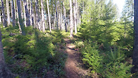
Classic XC ride complete with miles of undulating trail, roots, rock gardens and fast flowy sections. It is best ridden as an out and back from Cold Creek Campground Day Use Area to a high point before the steep descent to Lucia Falls. The final descent to Lucia Falls is steep with many tight switchbacks making for a difficult climb out with little reward. From the high point, there are excellent views of Mt. Saint Helens. The return leg is roughly 60% descending so it makes for a nice finish.

Disclaimer

Lowland sections can be quite muddy during the spring. Midsummer, the clear cut sections can also be overgrown.

Local Trail Association
Traditionally Indigenous Territory

Recent Activity on Trail

Past Week
  • 0 rides
  •  
6 Months
  • 5 rides
  • 17 miles avg distance
All
  • 49 rides
  • Last: May 28, 2026
c1c2c3c4
January
February
March
April
May
June
July
August
September
October
November
December
update trails status or condition

Bells Mountain Trail Reports

statusdatedescription
Jun 15, 2026 @ 3:36pm (America/Los_Angeles)
Jun 15, 2026
Quite overgrown until Sword Fern region
May 9, 2026 @ 12:40pm (America/Los_Angeles)
May 9, 2026
No downed trees. Great dirt, no mud. Not too overgrown yet. Wild flowers in the clearcut meadows are just starting to bloom. Probably a few weeks...
Sep 26, 2025 @ 10:04am (America/Los_Angeles)
Sep 26, 2025
Two and half trees down (one tree is mostly rideable) that requires dismounting. Unsure of exact location, but somewhere between the Sword Fern TH...
Aug 21, 2025 @ 8:42am
Aug 21, 2025
One tree down after the steepest section / chute past the view of Saint Helens heading down towards 2.5 mile trail. Slightly overgrown.
Jul 13, 2025 @ 4:39pm
Jul 13, 2025
Rideable, but getting overgrown in many places.
more »
Status:
on Jun 15, 2026
Avg: 3.22 (13 votes)
Your vote: 0

view (245)
close
3D
Trail Conditions
  • Unknown
  • Snow Groomed
  • Snow Packed
  • Snow Covered
  • Snow Cover Partial
  • Freeze/thaw Cycle
  • Icy
  • Prevalent Mud
  • Wet
  • Variable
  • Ideal
  • Dry
  • Very Dry
Trail Flow (Ridden Direction)
Trailforks scans users ridelogs to determine the most popular direction each trail is ridden. A good flowing trail network will have most trails flowing in a single direction according to their intension.
The colour categories are based on what percentage of riders are riding a trail in its intended direction.
  • > 96%
  • > 90%
  • > 80%
  • > 70%
  • > 50%
  • < 50%
  • bi-directional trail
  • no data
Trail Last Ridden
Trailforks scans ridelogs to determine the last time a trail was ridden.
  • < 2 days
  • < 1 week
  • < 2 weeks
  • < 1 month
  • < 6 months
  • > 6 months
Trail Ridden Direction
The intended direction a trail should be ridden.
  • Downhill Only
  • Downhill Primary
  • Both Directions
  • Uphill Primary
  • Uphill Only
  • One Direction
Contribute Details
Colors indicate trail is missing specified detail.
  • Description
  • Photos
  • Description & Photos
  • Videos
Trail Popularity ?
Trailforks scans ridelogs to determine which trails are ridden the most in the last 9 months. Trails are compared with nearby trails in the same city region with a possible 25 colour shades. Think of this as a heatmap, more rides = more kinetic energy = warmer colors.
  • most popular
  • popular
  • less popular
  • not popular
ATV/ORV/OHV Filter
Max Vehicle Width
inches
US Cell Coverage
Legend
cell carrier legend

Radar Time
Activity Recordings
Trailforks uses anonymized public activity data. ?
Activity Recordings
Trailforks uses anonymized public activity data. ?
Personal Heatmap
Activity Types
all / none
Options
2
Date range month
Winter Trails
Warning A routing network for winter maps does not exist. Selecting trails using the winter trails layer has been disabled.
Missing Trails
Most Popular
Least Popular
Trails are colored based on popularity. The more popular a trail is, the more red. Less popular trails trend towards green.
Jump Magnitude Heatmap
Heatmap of where riders jump on trails. Zoom in to see individual jumps, click circles to view jump details.
BC Backroad Status

Service Road Atlas is a free to use, community-driven service for viewing and creating reports on the numerous back-country service roads around B.C. and Alberta.

map legend
Slope Aspect
Direction the slope faces
Flat N NE E SE S SW W NW
Trails Deemphasized
Trails are shown in grey.
disable
Only show trails with no bike usage.
Enable
Suggested Layers
Based on selected activity type

    Save the current map location and zoom level as your default home location whenever this page is loaded.

    Save
        Directions to bells-mountain trailhead (45.751560, -122.327310)

        Photos

        73 more »
        66 |
        Sep 26, 2025 @ 10:05am
        Sep 26, 2025
        57 |
        Jul 25, 2025 @ 3:54pm
        Jul 25, 2025
        56 |
        Jul 25, 2025 @ 3:54pm
        Jul 25, 2025
        58 |
        Jul 25, 2025 @ 3:54pm
        Jul 25, 2025

        Videos

        1 more »
        VOTR Bells Mountain
        6:50 | 768 | Mar 20, 2018 , Battle Ground

        Routes with this trail

        5.0 45 miles 9,258 ft 12 Loop
        This is a tough route that I experimented with, failing after the first day as it was dumping rain and our...

        6 Reviews & Comments


        We hope you've been enjoying Trailforks!

        Create a FREE account to view trail comments and much more.

        • By andybrew & contributors
        • #53709 - 8,580 views

        Frequently Asked Questions About Bells Mountain

        Where is Bells Mountain located?
        Bells Mountain is located in Yacolt Burn State Forest, Battle Ground, Washington, United States. It is part of the Yacolt Burn State Forest trail network. The trailhead is located at coordinates 45.75156, -122.32731.
        How hard is Bells Mountain?
        Bells Mountain is rated as Blue difficulty. The physical rating is Moderate. The average grade is 1.7%. The climb difficulty is rated Blue.
        What is the elevation gain for Bells Mountain?
        Bells Mountain has 1,147 ft of elevation gain. The trail has 1,906 ft of elevation descent. The elevation ranges from 547 ft to 1,574 ft.
        Is Bells Mountain a point to point trail?
        Bells Mountain is not a point to point trail. The direction is Both Directions. The trail type is singletrack.

        Hit the Trail

        Open in App

        Get this trail on your phone instantly.
        open trail in app

        Download Trail

        Save to wishlist, Garmin & download.
        save the trail

        Find Related Routes

        Find routes and users activities that include this trail.
        find routes for this trail

        You must enter a description before submitting.