more stats
6.0 miles
Distance
2,977 ft
Climb
-7 ft
Descent
01:33:31
Avg time
2,970 ft
Altitude change
5,720 ft
Altitude min
8,690 ft
Altitude max
5,720 ft
Altitude start
8,691 ft
Altitude end
9.3%
Grade
-2.9%
Grade max
46.1%
Grade min
6 miles
Distance climb
246 ft
Distance down
220 ft
Distance flat
01:33:31
Avg time

Ben Lomond Details

  • Activities
    • Mountain Bike
    • E-Bike
    • Hike
    • Trail Running
  • Riding Area
    North Fork Park
    Eden, Utah
  • Ref Number
    6042G
  • AKA
  • Difficulty Rating
  • Local Popularity
    55 in Mountain Biking [+]
    • 65 in E-Biking
    • 90 in Trail Running
    • 45 in Hiking
  • Global Ranking
    #103130 in Mountain Biking [+]
    • #63036 in E-Biking
    • #49289 in Trail Running
    • #107093 in Hiking
  • Hiking SAC Scale
    T2 Mountain Hiking
  • Trail Type
    Singletrack
  • Direction
    Both Directions
  • Climb Difficulty
    Black Diamond
  • Physical Rating
    Hard
  • Trail Visibility
    Always easy to follow
  • Dogs Allowed
    Yes
  • eBike Allowed

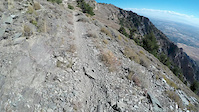
Difficult climb on a bike. Most riders tend to stay down in the North Fork area, but those looking for a really tough epic will hit this. It is more common as a hard hike to the top of Ben Lomond, Willard Peak and Inspiration Point

Trail Supporters

  • USFS
    Land Manager
Local Trail Association
Traditionally Indigenous Territory

Recent Activity on Trail

Past Week
  • 0 rides
  •  
6 Months
  • 1 rides
  • 14 miles avg distance
All
  • 13 rides
  • Last: Jun 17, 2026
c1c2c3c4
January
February
March
April
May
June
July
August
September
October
November
December
update trails status or condition

Ben Lomond Trail Reports

Status:
on May 21, 2026
Dry
Avg: 4.06 (8 votes)
Your vote: 0

view (195)
close
3D
Trail Conditions
  • Unknown
  • Snow Groomed
  • Snow Packed
  • Snow Covered
  • Snow Cover Partial
  • Freeze/thaw Cycle
  • Icy
  • Prevalent Mud
  • Wet
  • Variable
  • Ideal
  • Dry
  • Very Dry
Trail Flow (Ridden Direction)
Trailforks scans users ridelogs to determine the most popular direction each trail is ridden. A good flowing trail network will have most trails flowing in a single direction according to their intension.
The colour categories are based on what percentage of riders are riding a trail in its intended direction.
  • > 96%
  • > 90%
  • > 80%
  • > 70%
  • > 50%
  • < 50%
  • bi-directional trail
  • no data
Trail Last Ridden
Trailforks scans ridelogs to determine the last time a trail was ridden.
  • < 2 days
  • < 1 week
  • < 2 weeks
  • < 1 month
  • < 6 months
  • > 6 months
Trail Ridden Direction
The intended direction a trail should be ridden.
  • Downhill Only
  • Downhill Primary
  • Both Directions
  • Uphill Primary
  • Uphill Only
  • One Direction
Contribute Details
Colors indicate trail is missing specified detail.
  • Description
  • Photos
  • Description & Photos
  • Videos
Trail Popularity ?
Trailforks scans ridelogs to determine which trails are ridden the most in the last 9 months. Trails are compared with nearby trails in the same city region with a possible 25 colour shades. Think of this as a heatmap, more rides = more kinetic energy = warmer colors.
  • most popular
  • popular
  • less popular
  • not popular
ATV/ORV/OHV Filter
Max Vehicle Width
inches
US Cell Coverage
Legend
cell carrier legend

Radar Time
Activity Recordings
Trailforks uses anonymized public activity data. ?
Activity Recordings
Trailforks uses anonymized public activity data. ?
Personal Heatmap
Activity Types
all / none
Options
2
Date range month
Winter Trails
Warning A routing network for winter maps does not exist. Selecting trails using the winter trails layer has been disabled.
Missing Trails
Most Popular
Least Popular
Trails are colored based on popularity. The more popular a trail is, the more red. Less popular trails trend towards green.
Jump Magnitude Heatmap
Heatmap of where riders jump on trails. Zoom in to see individual jumps, click circles to view jump details.
BC Backroad Status

Service Road Atlas is a free to use, community-driven service for viewing and creating reports on the numerous back-country service roads around B.C. and Alberta.

map legend
Slope Aspect
Direction the slope faces
Flat N NE E SE S SW W NW
Trails Deemphasized
Trails are shown in grey.
disable
Only show trails with no bike usage.
Enable
Suggested Layers
Based on selected activity type

    Save the current map location and zoom level as your default home location whenever this page is loaded.

    Save
        Directions to ben-lomond trailhead (41.369480, -111.908970)

        Photos

        20 more »
        230 |
        Jan 17, 2020 @ 2:56am
        Jan 17, 2020
        155 |
        Aug 10, 2019 @ 9:24pm
        Aug 10, 2019
        208 |
        Aug 10, 2019 @ 9:24pm
        Aug 10, 2019
        152 |
        Aug 10, 2019 @ 9:23pm
        Aug 10, 2019

        Videos

        1 more »
        Ben Lomond part 1
        4:15 | 428 | Oct 4, 2018 , Eden

        Trail Lists

        Routes with this trail

        4.0 45 miles 7,723 ft 7 Point to Point
        12 miles 2,541 ft 2 Point to Point
        Adventure Climb up . Turn Left on Trail. Continue climbing to the submit. Hangout, refuel, and enjoy the...
        22 miles 5,364 ft 7 Point to Point
        Climbs over Eyrie Peak and Ben Lomond, although you'll have to take side trips to reach the summit of...

        3 Reviews & Comments


        We hope you've been enjoying Trailforks!

        Create a FREE account to view trail comments and much more.

        • By toddTF Pro Trailforks & contributors
        • #10999 - 7,214 views

        Frequently Asked Questions About Ben Lomond

        Where is Ben Lomond located?
        Ben Lomond is located in North Fork Park, Eden, Utah, United States. It is part of the North Fork Park trail network. The trailhead is located at coordinates 41.36948, -111.90897.
        How hard is Ben Lomond?
        Ben Lomond is rated as Black Diamond difficulty. The physical rating is Hard. The average grade is 9.3%. The climb difficulty is rated Black Diamond.
        What is the elevation gain for Ben Lomond?
        Ben Lomond has 2,977 ft of elevation gain. The trail has 7 ft of elevation descent. The elevation ranges from 5,720 ft to 8,690 ft.
        Is Ben Lomond a point to point trail?
        Ben Lomond is not a point to point trail. The direction is Both Directions. The trail type is singletrack.

        Hit the Trail

        Open in App

        Get this trail on your phone instantly.
        open trail in app

        Download Trail

        Save to wishlist, Garmin & download.
        save the trail

        Find Related Routes

        Find routes and users activities that include this trail.
        find routes for this trail

        You must enter a description before submitting.