more stats
2.8 miles
Distance
250 ft
Climb
-1,431 ft
Descent
00:40:54
Avg time
-1,181 ft
Altitude change
2,318 ft
Altitude min
3,568 ft
Altitude max
3,499 ft
Altitude start
2,318 ft
Altitude end
-45.302%
Grade max
21.813%
Grade min
3,479 ft
Distance climb
2 miles
Distance down
230 ft
Distance flat
00:40:54
Avg time

Bennett Gap Trail Details

  • Activities
    • Mountain Bike
    • Hike
    • Trail Running
  • Riding Area
    Pisgah / Brevard
    Brevard, North Carolina
  • Ref Number
    #138
  • Difficulty Rating
  • Voted Difficulty
    Double Black Diamond (2 votes)
  • Local Popularity
    85 in Mountain Biking [+]
    • 70 in Trail Running
    • 70 in Hiking
  • Global Ranking
    #11737 in Mountain Biking [+]
    • #2073 in Trail Running
    • #3088 in Hiking
  • Trail Type
    Singletrack
  • Direction
    Downhill Primary
    Popular Direction Shown
  • Dogs Allowed
    Yes
  • eBike Allowed
  • Land Owner
    USFS

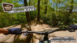
Now open year round to bikes thanks to trail advocacy. Excellent ridgetop views of Looking Glass Rock, Cedar Rock, and the Davidson River valley. Technical sections near the intersection with Perry Cove Tr. with nearly sheer drop-offs on the downhill side. Fast if riding downhill.

Trail Supporters

  • since 2016
    Maintainer

  • USFS
    Land Manager

Recent Activity on Trail

Past Week
  • 3 rides
  • 13 miles average
6 Months
  • 135 rides
  • 17 miles avg distance
All
  • 905 rides
  • Last: Jun 20, 2026
c1c2c3c4
January
February
March
April
May
June
July
August
September
October
November
December
update trails status or condition

Bennett Gap Trail Trail Reports

statusdatedescription
Feb 21, 2026 @ 11:47am (America/New_York)
Feb 21, 2026
Muddy in spots and leafy
Dec 21, 2025 @ 11:16am (America/New_York)
Dec 21, 2025
Leafy up top, lower section past Coontree is ideal as the prescribed burn a few weeks ago cleared out leaves and debris
Sep 14, 2025 @ 11:17am (America/Kentucky/Monticello)
Sep 14, 2025
Sep 6, 2025 @ 9:03am
Sep 6, 2025
Jun 20, 2025 @ 1:10pm
Jun 20, 2025
Somewhat overgrown in spots.
more »
Status:
on Feb 21, 2026
Variable
Avg: 4.52 (55 votes)
Your vote: 0

view (7,263)
close
3D
Trail Conditions
  • Unknown
  • Snow Groomed
  • Snow Packed
  • Snow Covered
  • Snow Cover Partial
  • Freeze/thaw Cycle
  • Icy
  • Prevalent Mud
  • Wet
  • Variable
  • Ideal
  • Dry
  • Very Dry
Trail Flow (Ridden Direction)
Trailforks scans users ridelogs to determine the most popular direction each trail is ridden. A good flowing trail network will have most trails flowing in a single direction according to their intension.
The colour categories are based on what percentage of riders are riding a trail in its intended direction.
  • > 96%
  • > 90%
  • > 80%
  • > 70%
  • > 50%
  • < 50%
  • bi-directional trail
  • no data
Trail Last Ridden
Trailforks scans ridelogs to determine the last time a trail was ridden.
  • < 2 days
  • < 1 week
  • < 2 weeks
  • < 1 month
  • < 6 months
  • > 6 months
Trail Ridden Direction
The intended direction a trail should be ridden.
  • Downhill Only
  • Downhill Primary
  • Both Directions
  • Uphill Primary
  • Uphill Only
  • One Direction
Contribute Details
Colors indicate trail is missing specified detail.
  • Description
  • Photos
  • Description & Photos
  • Videos
Trail Popularity ?
Trailforks scans ridelogs to determine which trails are ridden the most in the last 9 months. Trails are compared with nearby trails in the same city region with a possible 25 colour shades. Think of this as a heatmap, more rides = more kinetic energy = warmer colors.
  • most popular
  • popular
  • less popular
  • not popular
ATV/ORV/OHV Filter
Max Vehicle Width
inches
US Cell Coverage
Legend
cell carrier legend

Radar Time
Activity Recordings
Trailforks uses anonymized public activity data. ?
Activity Recordings
Trailforks uses anonymized public activity data. ?
Personal Heatmap
Activity Types
all / none
Options
2
Date range month
Winter Trails
Warning A routing network for winter maps does not exist. Selecting trails using the winter trails layer has been disabled.
Missing Trails
Most Popular
Least Popular
Trails are colored based on popularity. The more popular a trail is, the more red. Less popular trails trend towards green.
Jump Magnitude Heatmap
Heatmap of where riders jump on trails. Zoom in to see individual jumps, click circles to view jump details.
BC Backroad Status

Service Road Atlas is a free to use, community-driven service for viewing and creating reports on the numerous back-country service roads around B.C. and Alberta.

map legend
Slope Aspect
Direction the slope faces
Flat N NE E SE S SW W NW
Trails Deemphasized
Trails are shown in grey.
disable
Only show trails with no bike usage.
Enable
Suggested Layers
Based on selected activity type

    Save the current map location and zoom level as your default home location whenever this page is loaded.

    Save
        Directions to bennett-gap-trail trailhead (35.322100, -82.774750)

        Photos

        53 more »
        2,699 |
        May 1, 2018 @ 5:31pm
        May 1, 2018
        45 |
        May 5, 2026 @ 12:43pm
        May 5, 2026
        252 |
        Aug 23, 2023 @ 6:25am
        Aug 23, 2023
        244 |
        Nov 25, 2022 @ 11:48am
        Nov 25, 2022

        Videos

        22 more »
        youtuber Bennet Gap, Buckwheat Knob, Avery Creek trails
        13:29 | 1122 | May 22, 2018 , Brevard
        youtuber Surviving Bennett Gap • Pisgah Trip - Part 5...
        13:22 | 1390 | Apr 22, 2019 , Brevard
        youtuber Getting a slice of humble pie at Bennett Gap...
        11:47 | 1425 | Mar 15, 2018 , Brevard
        How Hard IS Pisgah's Hardest Sanctioned MTB...
        13:03 | 262 | Jul 22, 2024 , Brevard

        Routes with this trail

        5.0 10 miles 2,061 ft 8
        Classic Ranger District ride tying together Avery, Buckwheat and Bennet.
        3.0 14 miles 2,935 ft 5 Loop
        A great route through Pisgah highlighting well known descents, Avery Creek, Bennet Gap. As this route...
        19 miles 3,520 ft 6 Loop
        Pisgah Ranger District loop. Start at the Thrift Cove parking lot and make your way up the Avery Creek FR...

        Trail Events

        9 Reviews & Comments


        We hope you've been enjoying Trailforks!

        Create a FREE account to view trail comments and much more.

        • By blowmyfuseTF Pro & contributors
        • #28411 - 20,702 views

        Frequently Asked Questions About Bennett Gap Trail

        Where is Bennett Gap Trail located?
        Bennett Gap Trail is located in Pisgah / Brevard, Brevard, North Carolina, United States. It is part of the Pisgah / Brevard trail network. The trailhead is located at coordinates 35.3221, -82.77475.
        How hard is Bennett Gap Trail?
        Bennett Gap Trail is rated as Black Diamond difficulty.
        What is the elevation gain for Bennett Gap Trail?
        Bennett Gap Trail has 250 ft of elevation gain. The trail has 1,431 ft of elevation descent. The elevation ranges from 2,318 ft to 3,568 ft.
        Is Bennett Gap Trail a point to point trail?
        Bennett Gap Trail is not a point to point trail. The direction is Downhill Primary. The trail type is singletrack.

        Hit the Trail

        Open in App

        Get this trail on your phone instantly.
        open trail in app

        Download Trail

        Save to wishlist, Garmin & download.
        save the trail

        Find Related Routes

        Find routes and users activities that include this trail.
        find routes for this trail

        You must enter a description before submitting.