more stats
2.6 miles
Distance
-1,156 ft
Descent
00:19:13
Avg time
-1,157 ft
Altitude change
8,033 ft
Altitude min
9,190 ft
Altitude max
9,190 ft
Altitude start
8,031 ft
Altitude end
-8.5%
Grade
-60.7%
Grade max
0.8%
Grade min
213 ft
Distance climb
2 miles
Distance down
318 ft
Distance flat
00:19:13
Avg time

Bergen Peak Details

  • Activities
    • Mountain Bike
    • E-Bike
    • Hike
    • Trail Running
  • Riding Area
    Elk Meadow Park
    Evergreen, Colorado
  • Difficulty Rating
  • Voted Difficulty
    Black Diamond (1 vote)
  • Local Popularity
    65 in Mountain Biking [+]
    • 75 in E-Biking
    • 80 in Trail Running
    • 65 in Hiking
  • Global Ranking
    #94528 in Mountain Biking [+]
    • #15602 in E-Biking
    • #82413 in Trail Running
    • #89598 in Hiking
  • Trail Type
    Singletrack
  • Direction
    Both Directions
  • Climb Difficulty
    Black Diamond
  • Physical Rating
    Hard
  • Dogs Allowed
    Yes
  • eBike Allowed
    Yes up to Class 1

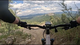
Can be ridden as a long technical climb or descent. Some spots will be hike-a-bike depending on your skill level, but can be mostly ridden by a fit intermediate rider.

Local Trail Association
Traditionally Indigenous Territory

Recent Activity on Trail

Past Week
  • 1 rides
  • 9 miles average
6 Months
  • 19 rides
  • 10 miles avg distance
All
  • 249 rides
  • Last: Jun 15, 2026
c1c2c3c4
January
February
March
April
May
June
July
August
September
October
November
December
update trails status or condition

Bergen Peak Trail Reports

statusdatedescription
Mar 28, 2026 @ 6:13pm (America/Denver)
Mar 28, 2026
Many Large trees down across trail, blocking trail. Generally, at the top. Too Long was clear
Jun 7, 2025 @ 5:53am
Jun 7, 2025
one trees down on the flat rocky area but can easily get around.
Jun 6, 2025 @ 8:36am
Jun 6, 2025
Apr 22, 2025 @ 10:02pm
Apr 22, 2025
Unknown current condition, but this trail has reopened
Jan 13, 2025 @ 12:55pm
Jan 13, 2025
Half the park is closed right now
more »
Status:
on Mar 28, 2026
Ideal
Avg: 3.57 (15 votes)
Your vote: 0

view (2,341)
close
3D
Trail Conditions
  • Unknown
  • Snow Groomed
  • Snow Packed
  • Snow Covered
  • Snow Cover Partial
  • Freeze/thaw Cycle
  • Icy
  • Prevalent Mud
  • Wet
  • Variable
  • Ideal
  • Dry
  • Very Dry
Trail Flow (Ridden Direction)
Trailforks scans users ridelogs to determine the most popular direction each trail is ridden. A good flowing trail network will have most trails flowing in a single direction according to their intension.
The colour categories are based on what percentage of riders are riding a trail in its intended direction.
  • > 96%
  • > 90%
  • > 80%
  • > 70%
  • > 50%
  • < 50%
  • bi-directional trail
  • no data
Trail Last Ridden
Trailforks scans ridelogs to determine the last time a trail was ridden.
  • < 2 days
  • < 1 week
  • < 2 weeks
  • < 1 month
  • < 6 months
  • > 6 months
Trail Ridden Direction
The intended direction a trail should be ridden.
  • Downhill Only
  • Downhill Primary
  • Both Directions
  • Uphill Primary
  • Uphill Only
  • One Direction
Contribute Details
Colors indicate trail is missing specified detail.
  • Description
  • Photos
  • Description & Photos
  • Videos
Trail Popularity ?
Trailforks scans ridelogs to determine which trails are ridden the most in the last 9 months. Trails are compared with nearby trails in the same city region with a possible 25 colour shades. Think of this as a heatmap, more rides = more kinetic energy = warmer colors.
  • most popular
  • popular
  • less popular
  • not popular
ATV/ORV/OHV Filter
Max Vehicle Width
inches
US Cell Coverage
Legend
cell carrier legend

Radar Time
Activity Recordings
Trailforks uses anonymized public activity data. ?
Activity Recordings
Trailforks uses anonymized public activity data. ?
Personal Heatmap
Activity Types
all / none
Options
2
Date range month
Winter Trails
Warning A routing network for winter maps does not exist. Selecting trails using the winter trails layer has been disabled.
Missing Trails
Most Popular
Least Popular
Trails are colored based on popularity. The more popular a trail is, the more red. Less popular trails trend towards green.
Jump Magnitude Heatmap
Heatmap of where riders jump on trails. Zoom in to see individual jumps, click circles to view jump details.
BC Backroad Status

Service Road Atlas is a free to use, community-driven service for viewing and creating reports on the numerous back-country service roads around B.C. and Alberta.

map legend
Slope Aspect
Direction the slope faces
Flat N NE E SE S SW W NW
Trails Deemphasized
Trails are shown in grey.
disable
Only show trails with no bike usage.
Enable
Suggested Layers
Based on selected activity type

    Save the current map location and zoom level as your default home location whenever this page is loaded.

    Save
        Directions to bergen-peak trailhead (39.666080, -105.391350)

        Photos

        19 more »
        288 |
        Aug 4, 2019 @ 8:14am
        Aug 4, 2019
        250 |
        Aug 4, 2019 @ 8:13am
        Aug 4, 2019
        236 |
        Aug 4, 2019 @ 8:13am
        Aug 4, 2019
        249 |
        Aug 4, 2019 @ 8:12am
        Aug 4, 2019

        Videos

        2 more »
        youtuber CO MTB | Elk Meadows and Status Update
        18:04 | 1021 | Aug 7, 2018 , Evergreen
        Bergen Peak - Elk Meadow Park - Evergreen -...
        21:06 | 202 | Jun 29, 2024 , Evergreen

        Trail Lists

        Routes with this trail

        2.0 8 miles 1,689 ft 10 Loop
        technical climb, with a good dh section

        3 Reviews & Comments


        We hope you've been enjoying Trailforks!

        Create a FREE account to view trail comments and much more.

        • By toddTF Pro Trailforks & contributors
        • #13121 - 5,424 views

        Frequently Asked Questions About Bergen Peak

        Where is Bergen Peak located?
        Bergen Peak is located in Elk Meadow Park, Evergreen, Colorado, United States. It is part of the Elk Meadow Park trail network. The trailhead is located at coordinates 39.66608, -105.39135.
        How hard is Bergen Peak?
        Bergen Peak is rated as Black Diamond difficulty. The physical rating is Hard. The average grade is 8.5%. The climb difficulty is rated Black Diamond.
        What is the elevation gain for Bergen Peak?
        The trail has 1,156 ft of elevation descent. The elevation ranges from 8,033 ft to 9,190 ft.
        Is Bergen Peak a point to point trail?
        Bergen Peak is not a point to point trail. The direction is Both Directions. The trail type is singletrack.

        Hit the Trail

        Open in App

        Get this trail on your phone instantly.
        open trail in app

        Download Trail

        Save to wishlist, Garmin & download.
        save the trail

        Find Related Routes

        Find routes and users activities that include this trail.
        find routes for this trail

        You must enter a description before submitting.