more stats
5.4 miles
Distance
590 ft
Climb
-589 ft
Descent
00:31:48
Avg time
-27 ft
Altitude min
69 ft
Altitude max
-13 ft
Altitude start
-13 ft
Altitude end
-47.9%
Grade max
24.1%
Grade min
2 miles
Distance climb
2 miles
Distance down
1 mile
Distance flat
00:31:48
Avg time

Bergschenhoek Details

  • Activities
    • Mountain Bike
  • Riding Area
  • Difficulty Rating
  • Voted Difficulty
    Blue (4 votes)
  • Local Popularity
    100 in Mountain Biking
  • Global Ranking
    #19896 in Mountain Biking
  • Trail Type
    Singletrack
  • Bike Type
    AM, XC
  • Climb Difficulty
    Blue
  • Physical Rating
    Moderate
  • Season
    All season
  • Dogs Allowed
    Yes
  • eBike Allowed
  • TTFs on Trail
    Drop, Jump

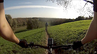
Really fun XC trail which ask quite a bit of your technical skills and physical condition. Fast descents and steep climbs.
Based around one of the higher hills on the western part of the Netherlands.

Access Info

You can start this trail at: Hoeksekade 141, 2661 JL Bergschenhoek

Recent Activity on Trail

Past Week
  • 0 rides
  •  
6 Months
  • 38 rides
  • 21 miles avg distance
All
  • 263 rides
  • Last: Jun 22, 2026
c1c2c3c4
January
February
March
April
May
June
July
August
September
October
November
December
Status:
on May 25, 2026
Avg: 4 (12 votes)
Your vote: 0

view (5,373)
close
3D
Trail Conditions
  • Unknown
  • Snow Groomed
  • Snow Packed
  • Snow Covered
  • Snow Cover Partial
  • Freeze/thaw Cycle
  • Icy
  • Prevalent Mud
  • Wet
  • Variable
  • Ideal
  • Dry
  • Very Dry
Trail Flow (Ridden Direction)
Trailforks scans users ridelogs to determine the most popular direction each trail is ridden. A good flowing trail network will have most trails flowing in a single direction according to their intension.
The colour categories are based on what percentage of riders are riding a trail in its intended direction.
  • > 96%
  • > 90%
  • > 80%
  • > 70%
  • > 50%
  • < 50%
  • bi-directional trail
  • no data
Trail Last Ridden
Trailforks scans ridelogs to determine the last time a trail was ridden.
  • < 2 days
  • < 1 week
  • < 2 weeks
  • < 1 month
  • < 6 months
  • > 6 months
Trail Ridden Direction
The intended direction a trail should be ridden.
  • Downhill Only
  • Downhill Primary
  • Both Directions
  • Uphill Primary
  • Uphill Only
  • One Direction
Contribute Details
Colors indicate trail is missing specified detail.
  • Description
  • Photos
  • Description & Photos
  • Videos
Trail Popularity ?
Trailforks scans ridelogs to determine which trails are ridden the most in the last 9 months. Trails are compared with nearby trails in the same city region with a possible 25 colour shades. Think of this as a heatmap, more rides = more kinetic energy = warmer colors.
  • most popular
  • popular
  • less popular
  • not popular
ATV/ORV/OHV Filter
Max Vehicle Width
inches
US Cell Coverage
Legend
cell carrier legend

Radar Time
Activity Recordings
Trailforks uses anonymized public activity data. ?
Activity Recordings
Trailforks uses anonymized public activity data. ?
Personal Heatmap
Activity Types
all / none
Options
2
Date range month
Winter Trails
Warning A routing network for winter maps does not exist. Selecting trails using the winter trails layer has been disabled.
Missing Trails
Most Popular
Least Popular
Trails are colored based on popularity. The more popular a trail is, the more red. Less popular trails trend towards green.
Jump Magnitude Heatmap
Heatmap of where riders jump on trails. Zoom in to see individual jumps, click circles to view jump details.
BC Backroad Status

Service Road Atlas is a free to use, community-driven service for viewing and creating reports on the numerous back-country service roads around B.C. and Alberta.

map legend
Slope Aspect
Direction the slope faces
Flat N NE E SE S SW W NW
Trails Deemphasized
Trails are shown in grey.
disable
Only show trails with no bike usage.
Enable
Suggested Layers
Based on selected activity type

    Save the current map location and zoom level as your default home location whenever this page is loaded.

    Save
        Directions to bergschenhoek trailhead (51.977820, 4.535260)

        Photos

        53 more »
        121 |
        Oct 16, 2025 @ 2:44am
        Oct 16, 2025
        56 |
        Sep 7, 2025 @ 11:55am
        Sep 7, 2025
        53 |
        Sep 7, 2025 @ 11:55am
        Sep 7, 2025
        67 |
        Aug 26, 2022 @ 12:05am
        Aug 26, 2022

        Videos

        44 more »
        youtuber Een best wel uitdagende route in de randstad...
        7:43 | 197 | Jan 2, 2024 , Bergschenhoek
        MTB Bergschenhoek - Skill Park
        0:58 | 959 | Jul 6, 2020 , Bergschenhoek
        Nightride B'hoek
        3:40 | 238 | Oct 21, 2015 , Bergschenhoek
        Bergschenhoek 01-11-2014
        6:38 | 735 | Nov 1, 2014 , Bergschenhoek

        Trail Lists

        1 Review & Comments


        We hope you've been enjoying Trailforks!

        Create a FREE account to view trail comments and much more.

        • By schralpcc & contributors
        • #9791 - 4,711 views

        Frequently Asked Questions About Bergschenhoek

        Where is Bergschenhoek located?
        Bergschenhoek is located in Bergschenhoek, Netherlands. It is part of the Bergschenhoek trail network. The trailhead is located at coordinates 51.97782, 4.53526.
        How hard is Bergschenhoek?
        Bergschenhoek is rated as Blue difficulty. The physical rating is Moderate. The climb difficulty is rated Blue.
        What is the elevation gain for Bergschenhoek?
        Bergschenhoek has 180 m of elevation gain. The trail has 180 m of elevation descent. The elevation ranges from -8 m to 21 m.
        How long is Bergschenhoek?
        Bergschenhoek is 8.6 km long. The trail type is singletrack.

        Hit the Trail

        Open in App

        Get this trail on your phone instantly.
        open trail in app

        Download Trail

        Save to wishlist, Garmin & download.
        save the trail

        Find Related Routes

        Find routes and users activities that include this trail.
        find routes for this trail

        You must enter a description before submitting.