more stats
5,121 ft
Distance
2 ft
Climb
-544 ft
Descent
00:08:27
Avg time
-543 ft
Altitude change
5,084 ft
Altitude min
5,630 ft
Altitude max
5,627 ft
Altitude start
5,085 ft
Altitude end
-10.6%
Grade
-27.9%
Grade max
4.2%
Grade min
141 ft
Distance climb
4,350 ft
Distance down
633 ft
Distance flat
00:08:27
Avg time

Berm & Ernie Details

  • Activities
    • Mountain Bike
    • Hike
    • Trail Running
  • Riding Area
    Jug Mountain
    McCall, Idaho
  • Difficulty Rating
  • Voted Difficulty
    Blue (2 votes)
  • Local Popularity
    95 in Mountain Biking [+]
    • 5 in Trail Running
    • 5 in Hiking
  • Global Ranking
    #29139 in Mountain Biking [+]
    • #131682 in Trail Running
    • #106997 in Hiking
  • Trail Type
    Singletrack
  • Bike Type
    AM
  • Climb Difficulty
    Green
  • Physical Rating
    Moderate
  • Dogs Allowed
    Yes
  • TTFs on Trail
    Berm, Drop, Jump

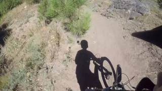
One of Idaho's premier flow trails Berm & Ernie features berms a' plenty! A few rock gardens exist towards the top of the trail, including a few optional black diamond lines. After the rock features its all speed and berms, with few fun doubles in between. The bottom section is all flow and high speed through the trees!

Local Trail Association
Traditionally Indigenous Territory

Recent Activity on Trail

Past Week
  • 3 rides
  • 8 miles average
6 Months
  • 22 rides
  • 10 miles avg distance
All
  • 368 rides
  • Last: Jun 17, 2026
c1c2c3c4
January
February
March
April
May
June
July
August
September
October
November
December
update trails status or condition

Berm & Ernie Trail Reports

statusdatedescription
Jun 1, 2025 @ 11:19am
Jun 1, 2025
Upper section is pretty great right now, lower section has some blown out sections. Pretty good overall still.
Jun 9, 2024 @ 3:23am
Jun 9, 2024
May 26, 2024 @ 3:52am
May 26, 2024
Jul 25, 2023 @ 4:01pm
Jul 25, 2023
Encountered a badger in the third berm corner. Might have had a burrow exit on the top, was too busy dodging badger to see for sure.
Jul 5, 2023 @ 8:01am
Jul 5, 2023
Excellent trail, best for an intermediate to have faith and roll the rock ‘drops’
more »
Status:
on Jun 1, 2025
Dry
Avg: 4.63 (19 votes)
Your vote: 0

view (3,429)
close
3D
Trail Conditions
  • Unknown
  • Snow Groomed
  • Snow Packed
  • Snow Covered
  • Snow Cover Partial
  • Freeze/thaw Cycle
  • Icy
  • Prevalent Mud
  • Wet
  • Variable
  • Ideal
  • Dry
  • Very Dry
Trail Flow (Ridden Direction)
Trailforks scans users ridelogs to determine the most popular direction each trail is ridden. A good flowing trail network will have most trails flowing in a single direction according to their intension.
The colour categories are based on what percentage of riders are riding a trail in its intended direction.
  • > 96%
  • > 90%
  • > 80%
  • > 70%
  • > 50%
  • < 50%
  • bi-directional trail
  • no data
Trail Last Ridden
Trailforks scans ridelogs to determine the last time a trail was ridden.
  • < 2 days
  • < 1 week
  • < 2 weeks
  • < 1 month
  • < 6 months
  • > 6 months
Trail Ridden Direction
The intended direction a trail should be ridden.
  • Downhill Only
  • Downhill Primary
  • Both Directions
  • Uphill Primary
  • Uphill Only
  • One Direction
Contribute Details
Colors indicate trail is missing specified detail.
  • Description
  • Photos
  • Description & Photos
  • Videos
Trail Popularity ?
Trailforks scans ridelogs to determine which trails are ridden the most in the last 9 months. Trails are compared with nearby trails in the same city region with a possible 25 colour shades. Think of this as a heatmap, more rides = more kinetic energy = warmer colors.
  • most popular
  • popular
  • less popular
  • not popular
ATV/ORV/OHV Filter
Max Vehicle Width
inches
US Cell Coverage
Legend
cell carrier legend

Radar Time
Activity Recordings
Trailforks uses anonymized public activity data. ?
Activity Recordings
Trailforks uses anonymized public activity data. ?
Personal Heatmap
Activity Types
all / none
Options
2
Date range month
Winter Trails
Warning A routing network for winter maps does not exist. Selecting trails using the winter trails layer has been disabled.
Missing Trails
Most Popular
Least Popular
Trails are colored based on popularity. The more popular a trail is, the more red. Less popular trails trend towards green.
Jump Magnitude Heatmap
Heatmap of where riders jump on trails. Zoom in to see individual jumps, click circles to view jump details.
BC Backroad Status

Service Road Atlas is a free to use, community-driven service for viewing and creating reports on the numerous back-country service roads around B.C. and Alberta.

map legend
Slope Aspect
Direction the slope faces
Flat N NE E SE S SW W NW
Trails Deemphasized
Trails are shown in grey.
disable
Only show trails with no bike usage.
Enable
Suggested Layers
Based on selected activity type

    Save the current map location and zoom level as your default home location whenever this page is loaded.

    Save
        Directions to berm--ernie trailhead (44.835850, -116.012590)

        Photos

        16 more »
        57 |
        Jun 18, 2025 @ 10:16pm
        Jun 18, 2025
        62 |
        Jun 18, 2025 @ 10:16pm
        Jun 18, 2025
        176 |
        Nov 14, 2019 @ 1:52pm
        Nov 14, 2019
        183 |
        Nov 14, 2019 @ 1:52pm
        Nov 14, 2019

        Videos

        2 more »
        Jug Mountain | Berm N Ernie, McCall Idaho MTB
        3:56 | 511 | Oct 19, 2021 , McCall
        Berm and Ernie Descent
        916 | Jul 23, 2017 , McCall

        Routes with this trail

        3.0 17 miles 2,803 ft 169 Loop Race
        2017 IES Jug Mountain Enduro (Pro / Expert / Sport) The third race of the 2017 Idaho Enduro Series is set...
        11 miles 1,675 ft 135 Loop Race
        2017 IES Jug Mountain Enduro (Beginner) The third race of the 2017 Idaho Enduro Series is set to take...
        1.0 23 miles 3,446 ft 45 Race
        2018 IES Jug Mountain PRO / EXPERT / SPORT Welcome to the final stop of the 2018 Idaho Enduro Series! We...

        4 Reviews & Comments


        We hope you've been enjoying Trailforks!

        Create a FREE account to view trail comments and much more.

        • By IdahoEnduroSeries & contributors
        • #61520 - 3,046 views

        Frequently Asked Questions About Berm & Ernie

        Where is Berm & Ernie located?
        Berm & Ernie is located in Jug Mountain, McCall, Idaho, United States. It is part of the Jug Mountain trail network. The trailhead is located at coordinates 44.83585, -116.01259.
        How hard is Berm & Ernie?
        Berm & Ernie is rated as Blue difficulty. The physical rating is Moderate. The average grade is 10.6%. The climb difficulty is rated Green.
        What is the elevation gain for Berm & Ernie?
        Berm & Ernie has 2 ft of elevation gain. The trail has 544 ft of elevation descent. The elevation ranges from 5,084 ft to 5,630 ft.
        How long is Berm & Ernie?
        Berm & Ernie is 5,121 ft long. The trail type is singletrack.

        Hit the Trail

        Open in App

        Get this trail on your phone instantly.
        open trail in app

        Download Trail

        Save to wishlist, Garmin & download.
        save the trail

        Find Related Routes

        Find routes and users activities that include this trail.
        find routes for this trail

        You must enter a description before submitting.