more stats
3.0 miles
Distance
3 ft
Climb
-1,845 ft
Descent
00:13:13
Avg time
-1,843 ft
Altitude change
4,215 ft
Altitude min
6,057 ft
Altitude max
6,057 ft
Altitude start
4,216 ft
Altitude end
-11.8%
Grade
-41.1%
Grade max
9.4%
Grade min
135 ft
Distance climb
3 miles
Distance down
709 ft
Distance flat
00:13:13
Avg time

Bermalade Details

  • Activities
    • Mountain Bike
  • Riding Area
    Sun Peaks Bike Park
    Sun Peaks, British Columbia
  • Difficulty Rating
  • Local Popularity
    80 in Mountain Biking
  • Global Ranking
    #43152 in Mountain Biking
  • Trail Type
    Machine Groomed
  • Bike Type
    DH
  • Direction
    Downhill Only
    Popular Direction Shown
  • TTFs on Trail
    Berm, Jump
  • Year Opened
    2019

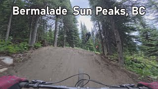
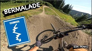
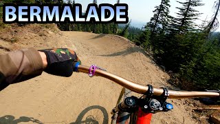
This machine built, intermediate level flow trail is a fun loving roller coaster pumped full of smooth flowing berms, rollers, jumps, and natural rock features.

New for 2021 A brand new top section and a re-worked bottom section extend Bermalade into a full top-to-bottom run.

Trail Supporters

Bike Park

Traditionally Indigenous Territory

Recent Activity on Trail

Past Week
  • 6 rides
  • 24 miles average
6 Months
  • 7 rides
  • 24 miles avg distance
All
  • 564 rides
  • Last: Jun 20, 2026
c1c2c3c4
January
February
March
April
May
June
July
August
September
October
November
December
update trails status or condition

Bermalade Trail Reports

statusdatedescription
Oct 4, 2025 @ 8:14am (America/Vancouver)
Oct 4, 2025
The bike park is now closed for the season, see you all in 2026! :D \m/
Aug 7, 2025 @ 1:50pm
Aug 7, 2025
Aug 5, 2025 @ 1:16pm
Aug 5, 2025
Top part is perfect. Lower is full of breaking bumps
Jul 31, 2024 @ 7:49pm
Jul 31, 2024
A few mint sections, but starting to get dry and loose. A surprisingly large number of braking bumps.
Jun 29, 2024 @ 11:34am
Jun 29, 2024
**report only for section below Level Up/Canada Line intersection: Great condition overall. Lower down, at ~75% mark, some muddy walls and...
more »
Status:
on Oct 4, 2025
Avg: 4.2 (28 votes)
Your vote: 0

view (4,029)
close
3D
Trail Conditions
  • Unknown
  • Snow Groomed
  • Snow Packed
  • Snow Covered
  • Snow Cover Partial
  • Freeze/thaw Cycle
  • Icy
  • Prevalent Mud
  • Wet
  • Variable
  • Ideal
  • Dry
  • Very Dry
Trail Flow (Ridden Direction)
Trailforks scans users ridelogs to determine the most popular direction each trail is ridden. A good flowing trail network will have most trails flowing in a single direction according to their intension.
The colour categories are based on what percentage of riders are riding a trail in its intended direction.
  • > 96%
  • > 90%
  • > 80%
  • > 70%
  • > 50%
  • < 50%
  • bi-directional trail
  • no data
Trail Last Ridden
Trailforks scans ridelogs to determine the last time a trail was ridden.
  • < 2 days
  • < 1 week
  • < 2 weeks
  • < 1 month
  • < 6 months
  • > 6 months
Trail Ridden Direction
The intended direction a trail should be ridden.
  • Downhill Only
  • Downhill Primary
  • Both Directions
  • Uphill Primary
  • Uphill Only
  • One Direction
Contribute Details
Colors indicate trail is missing specified detail.
  • Description
  • Photos
  • Description & Photos
  • Videos
Trail Popularity ?
Trailforks scans ridelogs to determine which trails are ridden the most in the last 9 months. Trails are compared with nearby trails in the same city region with a possible 25 colour shades. Think of this as a heatmap, more rides = more kinetic energy = warmer colors.
  • most popular
  • popular
  • less popular
  • not popular
ATV/ORV/OHV Filter
Max Vehicle Width
inches
US Cell Coverage
Legend
cell carrier legend

Radar Time
Activity Recordings
Trailforks uses anonymized public activity data. ?
Activity Recordings
Trailforks uses anonymized public activity data. ?
Personal Heatmap
Activity Types
all / none
Options
2
Date range month
Winter Trails
Warning A routing network for winter maps does not exist. Selecting trails using the winter trails layer has been disabled.
Missing Trails
Most Popular
Least Popular
Trails are colored based on popularity. The more popular a trail is, the more red. Less popular trails trend towards green.
Jump Magnitude Heatmap
Heatmap of where riders jump on trails. Zoom in to see individual jumps, click circles to view jump details.
BC Backroad Status

Service Road Atlas is a free to use, community-driven service for viewing and creating reports on the numerous back-country service roads around B.C. and Alberta.

map legend
Slope Aspect
Direction the slope faces
Flat N NE E SE S SW W NW
Trails Deemphasized
Trails are shown in grey.
disable
Only show trails with no bike usage.
Enable
Suggested Layers
Based on selected activity type

    Save the current map location and zoom level as your default home location whenever this page is loaded.

    Save
        Directions to bermalade trailhead (50.903950, -119.912450)

        Photos

        13 more »
        384 |
        Jun 17, 2021 @ 11:28am
        Jun 17, 2021
        331 |
        Jun 17, 2021 @ 11:11am
        Jun 17, 2021
        242 |
        Jun 17, 2021 @ 11:01am
        Jun 17, 2021
        213 |
        Jun 17, 2021 @ 9:46am
        Jun 17, 2021

        Videos

        8 more »
        youtuber Bermalade - Sun Peaks, BC
        7:41 | 73 | Sep 24, 2025 , Sun Peaks
        youtuber BERMALADE | Blue trail | SUN PEAKS Bike Park
        9:00 | 121 | Sep 9, 2024 , Sun Peaks
        youtuber The FLOWIEST Berms and Sick Jumps! 'Bermalade'...
        10:31 | 592 | Aug 13, 2021 , Sun Peaks
        youtuber Riding Bermalade until I get a Flat | Sunpeaks...
        10:14 | 105 | Sep 7, 2024 , Sun Peaks

        Routes with this trail

        71 miles 29,933 ft 37
        An attempt at riding every trail in Sun Peaks over a weekend.

        3 Reviews & Comments


        We hope you've been enjoying Trailforks!

        Create a FREE account to view trail comments and much more.

        • By sunpeaksbikeparkTF Pro SPBP & contributors
        • #204644 - 2,852 views

        Frequently Asked Questions About Bermalade

        Where is Bermalade located?
        Bermalade is located in Sun Peaks Bike Park, Sun Peaks, British Columbia, Canada. It is part of the Sun Peaks Bike Park trail network. The trailhead is located at coordinates 50.90395, -119.91245.
        How hard is Bermalade?
        Bermalade is rated as Blue difficulty. The average grade is 11.8%.
        What is the elevation gain for Bermalade?
        Bermalade has 3 ft of elevation gain. The trail has 1,845 ft of elevation descent. The elevation ranges from 4,215 ft to 6,057 ft.
        Is Bermalade a point to point trail?
        Yes, Bermalade is a point to point trail. The direction is Downhill Only. The trail type is machine groomed.

        Hit the Trail

        Open in App

        Get this trail on your phone instantly.
        open trail in app

        Download Trail

        Save to wishlist, Garmin & download.
        save the trail

        Find Related Routes

        Find routes and users activities that include this trail.
        find routes for this trail

        You must enter a description before submitting.