more stats
14.1 miles
Distance
1,960 ft
Climb
-1,855 ft
Descent
01:31:53
Avg time
106 ft
Altitude change
895 ft
Altitude min
1,182 ft
Altitude max
918 ft
Altitude start
1,024 ft
Altitude end
0.142%
Grade
-21.963%
Grade max
30.038%
Grade min
7 miles
Distance climb
6 miles
Distance down
1 mile
Distance flat
01:31:53
Avg time

Berryman Trail Details

  • Activities
    • Mountain Bike
    • Hike
    • Trail Running
  • Riding Area
    Ozark Trail
    Potosi, Missouri
  • Difficulty Rating
  • Local Popularity
    100 in Mountain Biking [+]
    • 100 in Trail Running
    • 5 in Hiking
  • Global Ranking
    #42845 in Mountain Biking [+]
    • #75049 in Trail Running
    • #68877 in Hiking
  • Trail Type
    Singletrack
  • Bike Type
    XC
  • Direction
    Both Directions
    Popular Direction Shown
  • Climb Difficulty
    Blue
  • Physical Rating
    Hard
  • Season
    Jan-Dec.
  • Dogs Allowed
    Yes
  • Year Opened
    2015
  • Land Owner

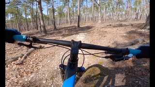
This trail isn't perfect, but it's hard to say anything bad about a 70 year old trail which has stood up this well to decades of use and abuse from hikers, bikers, ATVs, and equestrians.

The trail is a rocky 26 mile loop located in the heart of the Mark Twain National Forest. Designated as one of IMBA's epic rides, it traverses several Ozark hills and features long, sustained climbs and fast, rocky descents. The trail is customarily divided into 2 parts; the western 14 mile section between Berryman Campground trailhead and the Brazil Creek Campground trailhead, and the eastern 10 miles from Brazil Creek back to the Berryman Campground which completes the loop. The Courtois Section of the Ozark Trail makes use of the western part of the loop from where it joins it at Harmon Spring, to just west of the Berryman Campground. The Brazil Creek to Berryman Campground section has numerous climbs and descents, none of them really steep, which cross several valleys. This section is also quite rocky with many exposed roots. The western section, while longer, generally contains less climbing, but isn't necessarily easier. A complete gps track of the loop is available as a route.

The trail can be ridden in either direction and is open to bikers, hikers, and equestrians so be sure to give right-of-way. While many prefer to go in a clockwise direction it is just as fun to go the opposite and feels like a completely different trail.

A few sections are becoming eroded from illegal trail use and heavy rain, so take caution on the descents. The trail is resistant to light rain due to its rocky nature, however, please avoid this trail if it has rained significantly over the past 24 hours. Several lengthly stretches are mostly dirt and become mud bogs which are slow to dry. There are several small to medium water crossings so bring extra socks.

Logging is permitted in the Mark Twain National Forest so be aware of the trail direction and bring a map The trail crosses fireroads several times so there are many bailout options if you get tired or injured. Recently, some new "BT" markers have been put up at some of the more confusing intersections, so when in doubt, look for these. You are also encouraged to report any illegal motorized trail use to the Potosi Ranger station.

No drinking water is available on the trail, so be prepared and bring plenty of water. There is camping available at either campground on the loop - Brazil Creek or Berryman, the latter containing 8 camping spots, picnic tables and restrooms.

Access Info

I-44 to exit 218 Bourbon. South on N to W intersection. 5 miles to Brazil Creek Campground. From Potosi: take Hwy 8 west 16 miles; turn north onto County Road 207 (formerly FR2266). Go about 1.5 miles.

Trail Supporters

  • USFS
    Land Manager
Local Trail Association

Recent Activity on Trail

Past Week
  • 0 rides
  •  
6 Months
  • 1 rides
  • 27 miles avg distance
All
  • 71 rides
  • Last: Apr 25, 2026
c1c2c3c4
January
February
March
April
May
June
July
August
September
October
November
December
update trails status or condition

Berryman Trail Trail Reports

statusdatedescription
Oct 20, 2025 @ 12:25pm (America/Chicago)
Oct 20, 2025
well the rain on 10/18 pretty much erased the mtb race line so with the leaves falling it would be best to wait a bit before riding
Aug 26, 2023 @ 6:21am
Aug 26, 2023
6-7 trees down on the entire Berryman Loop.
Mar 27, 2021 @ 3:16pm
Mar 27, 2021
95 percent dry, only a couple low spots with seeps coming out of ground. Gtg
Jan 3, 2021 @ 9:00am
Jan 3, 2021
Trails still had leaves which were wet. Overall, wet trail but not muddy. Creeks had running water, but easily passable.
Sep 21, 2020 @ 4:48am
Sep 21, 2020
Feels like fall! Trail is in great condition. Only saw a couple horse riders today. Pretty empty for such an epic trail
more »
Status:
on Oct 20, 2025
Variable
Avg: 4.14 (8 votes)
Your vote: 0

view (783)
close
3D
Trail Conditions
  • Unknown
  • Snow Groomed
  • Snow Packed
  • Snow Covered
  • Snow Cover Partial
  • Freeze/thaw Cycle
  • Icy
  • Prevalent Mud
  • Wet
  • Variable
  • Ideal
  • Dry
  • Very Dry
Trail Flow (Ridden Direction)
Trailforks scans users ridelogs to determine the most popular direction each trail is ridden. A good flowing trail network will have most trails flowing in a single direction according to their intension.
The colour categories are based on what percentage of riders are riding a trail in its intended direction.
  • > 96%
  • > 90%
  • > 80%
  • > 70%
  • > 50%
  • < 50%
  • bi-directional trail
  • no data
Trail Last Ridden
Trailforks scans ridelogs to determine the last time a trail was ridden.
  • < 2 days
  • < 1 week
  • < 2 weeks
  • < 1 month
  • < 6 months
  • > 6 months
Trail Ridden Direction
The intended direction a trail should be ridden.
  • Downhill Only
  • Downhill Primary
  • Both Directions
  • Uphill Primary
  • Uphill Only
  • One Direction
Contribute Details
Colors indicate trail is missing specified detail.
  • Description
  • Photos
  • Description & Photos
  • Videos
Trail Popularity ?
Trailforks scans ridelogs to determine which trails are ridden the most in the last 9 months. Trails are compared with nearby trails in the same city region with a possible 25 colour shades. Think of this as a heatmap, more rides = more kinetic energy = warmer colors.
  • most popular
  • popular
  • less popular
  • not popular
ATV/ORV/OHV Filter
Max Vehicle Width
inches
US Cell Coverage
Legend
cell carrier legend

Radar Time
Activity Recordings
Trailforks uses anonymized public activity data. ?
Activity Recordings
Trailforks uses anonymized public activity data. ?
Personal Heatmap
Activity Types
all / none
Options
2
Date range month
Winter Trails
Warning A routing network for winter maps does not exist. Selecting trails using the winter trails layer has been disabled.
Missing Trails
Most Popular
Least Popular
Trails are colored based on popularity. The more popular a trail is, the more red. Less popular trails trend towards green.
Jump Magnitude Heatmap
Heatmap of where riders jump on trails. Zoom in to see individual jumps, click circles to view jump details.
BC Backroad Status

Service Road Atlas is a free to use, community-driven service for viewing and creating reports on the numerous back-country service roads around B.C. and Alberta.

map legend
Slope Aspect
Direction the slope faces
Flat N NE E SE S SW W NW
Trails Deemphasized
Trails are shown in grey.
disable
Only show trails with no bike usage.
Enable
Suggested Layers
Based on selected activity type

    Save the current map location and zoom level as your default home location whenever this page is loaded.

    Save
        Directions to berryman-trail trailhead (37.997650, -91.073300)

        Photos

        8 more »
        249 |
        Sep 21, 2020 @ 4:46am
        Sep 21, 2020
        221 |
        Sep 21, 2020 @ 4:46am
        Sep 21, 2020
        408 |
        Oct 20, 2017 @ 8:34pm
        Oct 20, 2017
        173 |
        Mar 27, 2021 @ 7:48pm
        Mar 27, 2021

        Videos

        1 more »
        Fast Singletrack | Mountain Biking the...
        14:58 | 157 | Mar 21, 2025 , Potosi

        Routes with this trail

        4.0 26 miles 2,442 ft 2 Loop
        This is the complete loop that makes up the . The section of Ozark Trail now uses 12 miles of the western...
        5.0 51 miles 5,261 ft 7 Race
        Current course for BT Epic held in October every year since 2008

        4 Reviews & Comments


        We hope you've been enjoying Trailforks!

        Create a FREE account to view trail comments and much more.

        • By pilznrTF Pro GORC & contributors
        • #36182 - 5,860 views

        Frequently Asked Questions About Berryman Trail

        Where is Berryman Trail located?
        Berryman Trail is located in Ozark Trail, Potosi, Missouri, United States. It is part of the Ozark Trail trail network. The trailhead is located at coordinates 37.99765, -91.0733.
        How hard is Berryman Trail?
        Berryman Trail is rated as Blue difficulty. The physical rating is Hard. The average grade is 0.142%. The climb difficulty is rated Blue.
        What is the elevation gain for Berryman Trail?
        Berryman Trail has 1,960 ft of elevation gain. The trail has 1,855 ft of elevation descent. The elevation ranges from 895 ft to 1,182 ft.
        Is Berryman Trail a point to point trail?
        Berryman Trail is not a point to point trail. The direction is Both Directions. The trail type is singletrack.

        Hit the Trail

        Open in App

        Get this trail on your phone instantly.
        open trail in app

        Download Trail

        Save to wishlist, Garmin & download.
        save the trail

        Find Related Routes

        Find routes and users activities that include this trail.
        find routes for this trail

        You must enter a description before submitting.