more stats
1.2 miles
Distance
625 ft
Climb
-25 ft
Descent
00:22:44
Avg time
599 ft
Altitude change
5,873 ft
Altitude min
6,477 ft
Altitude max
5,873 ft
Altitude start
6,473 ft
Altitude end
9.3%
Grade
-18.7%
Grade max
40.6%
Grade min
5,131 ft
Distance climb
482 ft
Distance down
804 ft
Distance flat
00:22:44
Avg time

Betasso Link Details

  • Activities
    • Mountain Bike
    • Hike
    • Trail Running
  • Riding Area
    Betasso Preserve
    Boulder, Colorado
  • Difficulty Rating
  • Voted Difficulty
    Black Diamond (2 votes)
  • Local Popularity
    90 in Mountain Biking [+]
    • 45 in Trail Running
    • 55 in Hiking
  • Global Ranking
    #29444 in Mountain Biking [+]
    • #98780 in Trail Running
    • #72646 in Hiking
  • Trail Type
    Singletrack
  • Bike Type
    AM, XC
  • Direction
    Both Directions
  • Climb Difficulty
    Black Diamond
  • Physical Rating
    Hard
  • Trail Visibility
    Always easy to follow
  • Dogs Allowed
    Yes
  • eBike Allowed
  • TTFs on Trail
    Roller Coaster
  • Land Owner

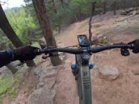
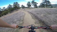
Betasso Link is a hard climb with very steep grades from the start on usually very dusty and loose rock. Pretty much all but the best are going to hike a bike for a little bit. The top mellow out in grade but still very flowy with some rocks. Down is a blast. Flowy up top and it gets rockier and steeper as you go. Definitely recommend hitting it up if near Boulder.

The Betasso Link trail s not closed to bikes on Wednesdays and Saturdays like the rest of Betasso Preserve. If you choose to ride on these days, please respect the trail closures on the rest of the system.

Access Info

Easy to access. Go into Boulder Canyon about 5 miles and the parking lot is on the right hand side, right before the tunnel. (This is coming from Boulder).

Local Trail Association
Traditionally Indigenous Territory

Recent Activity on Trail

Past Week
  • 5 rides
  • 19 miles average
6 Months
  • 94 rides
  • 15 miles avg distance
All
  • 516 rides
  • Last: Jun 19, 2026
c1c2c3c4
January
February
March
April
May
June
July
August
September
October
November
December
update trails status or condition

Betasso Link Trail Reports

Status:
on May 22, 2026
Ideal
Avg: 3.87 (17 votes)
Your vote: 0

view (8,148)
close
3D
Trail Conditions
  • Unknown
  • Snow Groomed
  • Snow Packed
  • Snow Covered
  • Snow Cover Partial
  • Freeze/thaw Cycle
  • Icy
  • Prevalent Mud
  • Wet
  • Variable
  • Ideal
  • Dry
  • Very Dry
Trail Flow (Ridden Direction)
Trailforks scans users ridelogs to determine the most popular direction each trail is ridden. A good flowing trail network will have most trails flowing in a single direction according to their intension.
The colour categories are based on what percentage of riders are riding a trail in its intended direction.
  • > 96%
  • > 90%
  • > 80%
  • > 70%
  • > 50%
  • < 50%
  • bi-directional trail
  • no data
Trail Last Ridden
Trailforks scans ridelogs to determine the last time a trail was ridden.
  • < 2 days
  • < 1 week
  • < 2 weeks
  • < 1 month
  • < 6 months
  • > 6 months
Trail Ridden Direction
The intended direction a trail should be ridden.
  • Downhill Only
  • Downhill Primary
  • Both Directions
  • Uphill Primary
  • Uphill Only
  • One Direction
Contribute Details
Colors indicate trail is missing specified detail.
  • Description
  • Photos
  • Description & Photos
  • Videos
Trail Popularity ?
Trailforks scans ridelogs to determine which trails are ridden the most in the last 9 months. Trails are compared with nearby trails in the same city region with a possible 25 colour shades. Think of this as a heatmap, more rides = more kinetic energy = warmer colors.
  • most popular
  • popular
  • less popular
  • not popular
ATV/ORV/OHV Filter
Max Vehicle Width
inches
US Cell Coverage
Legend
cell carrier legend

Radar Time
Activity Recordings
Trailforks uses anonymized public activity data. ?
Activity Recordings
Trailforks uses anonymized public activity data. ?
Personal Heatmap
Activity Types
all / none
Options
2
Date range month
Winter Trails
Warning A routing network for winter maps does not exist. Selecting trails using the winter trails layer has been disabled.
Missing Trails
Most Popular
Least Popular
Trails are colored based on popularity. The more popular a trail is, the more red. Less popular trails trend towards green.
Jump Magnitude Heatmap
Heatmap of where riders jump on trails. Zoom in to see individual jumps, click circles to view jump details.
BC Backroad Status

Service Road Atlas is a free to use, community-driven service for viewing and creating reports on the numerous back-country service roads around B.C. and Alberta.

map legend
Slope Aspect
Direction the slope faces
Flat N NE E SE S SW W NW
Trails Deemphasized
Trails are shown in grey.
disable
Only show trails with no bike usage.
Enable
Suggested Layers
Based on selected activity type

    Save the current map location and zoom level as your default home location whenever this page is loaded.

    Save
        Directions to betasso-link trailhead (40.007170, -105.333220)

        Photos

        15 more »
        165 |
        Jul 4, 2025 @ 5:18pm
        Jul 4, 2025
        128 |
        Jun 21, 2024 @ 9:39pm
        Jun 21, 2024
        123 |
        Jun 21, 2024 @ 9:39pm
        Jun 21, 2024
        157 |
        Jun 20, 2024 @ 10:07pm
        Jun 20, 2024

        Videos

        7 more »
        youtuber Riding Boulders in Boulder, CO | JF Rides Edition
        9:47 | 1077 | Jun 12, 2018 , Boulder
        Betasso Link
        121 | Jun 25, 2025 , Boulder
        Betasso Link - Boulder - Colorado
        7:01 | 645 | Jul 31, 2022 , Boulder
        Canyon Loop // Betasso Preserve
        3:45 | 243 | Apr 12, 2019 , Boulder

        Trail Lists

        Routes with this trail

        5.0 15 miles 1,506 ft 7 Loop
        This is the easiest way to ride Betasso from town. This route starts on the west side of the paved Boulder...
        Super Betasso Featured
        3.0 16 miles 2,128 ft 7 Loop
        In Boulder, a Super ride is one that starts from town, rather than at the trailhead. So start your Super...

        6 Reviews & Comments


        We hope you've been enjoying Trailforks!

        Create a FREE account to view trail comments and much more.

        • By toddTF Pro Trailforks & contributors
        • #13662 - 9,094 views

        Frequently Asked Questions About Betasso Link

        Where is Betasso Link located?
        Betasso Link is located in Betasso Preserve, Boulder, Colorado, United States. It is part of the Betasso Preserve trail network. The trailhead is located at coordinates 40.00717, -105.33322.
        How hard is Betasso Link?
        Betasso Link is rated as Black Diamond difficulty. The physical rating is Hard. The average grade is 9.3%. The climb difficulty is rated Black Diamond.
        What is the elevation gain for Betasso Link?
        Betasso Link has 190 m of elevation gain. The trail has 8 m of elevation descent. The elevation ranges from 1,790 m to 1,974 m.
        Is Betasso Link a point to point trail?
        Betasso Link is not a point to point trail. The direction is Both Directions. The trail type is singletrack.

        Hit the Trail

        Open in App

        Get this trail on your phone instantly.
        open trail in app

        Download Trail

        Save to wishlist, Garmin & download.
        save the trail

        Find Related Routes

        Find routes and users activities that include this trail.
        find routes for this trail

        You must enter a description before submitting.