more stats
4,997 ft
Distance
-676 ft
Descent
00:07:52
Avg time
-676 ft
Altitude change
1,344 ft
Altitude min
2,022 ft
Altitude max
2,020 ft
Altitude start
1,345 ft
Altitude end
-13.5%
Grade
-48.5%
Grade max
4.7%
Grade min
138 ft
Distance climb
4,724 ft
Distance down
131 ft
Distance flat
00:07:52
Avg time

Bifrost Trail Details

  • Activities
    • Mountain Bike
    • E-Bike
    • Hike
    • Trail Running
  • Riding Area
    Guardamonte Trail Area
    San Ponzo Semola
  • AKA
    Bifrost Short
  • Difficulty Rating
  • Local Popularity
    85 in Mountain Biking [+]
    • 95 in E-Biking
    • 5 in Trail Running
    • 5 in Hiking
  • Global Ranking
    #55271 in Mountain Biking [+]
    • #5930 in E-Biking
    • #130665 in Trail Running
    • #123770 in Hiking
  • Trail Exposure
    Normal
  • Trail Type
    Singletrack
  • Bike Type
    AM, XC
  • Climb Difficulty
    Green
  • Physical Rating
    Easy
  • Trail Visibility
    Always easy to follow
  • Season
    Da aprile e novembre, con fondo asciutto
  • eBike Allowed
    Yes up to Class 1
  • TTFs on Trail
    Berm, Jump
  • Year Opened
    2019
  • Land Owner
    Guardamonte Trail Area - GTA

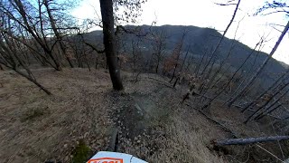
Nuovo trail in Val Curone, con accesso nei pressi del già noto Valhalla e arrivo lungo la strada asfaltata che va da San Sebastiano Curone a Musigliano. Sentiero per tutti, dai principianti ai biker più smaliziati.

Access Info

Strada asfaltata che da San Sebastiano Curone sale a Musigliano, appena prima di arrivare all'ingresso del Valhalla Trail si prende il primo tratto off-road di collegamento sino alla partenza del sentiero vero e proprio (a destra arrivando da Musigliano, a sinistra giungendo da San Sebastiano Curone).

Trail Supporters
Local Trail Association

Recent Activity on Trail

Past Week
  • 0 rides
  •  
6 Months
  • 7 rides
  • 15 miles avg distance
All
  • 35 rides
  • Last: Jun 14, 2026
c1c2c3c4
January
February
March
April
May
June
July
August
September
October
November
December
Status:
on Jun 13, 2026
Ideal
Avg: 4.15 (7 votes)
Your vote: 0

view (561)
close
3D
Trail Conditions
  • Unknown
  • Snow Groomed
  • Snow Packed
  • Snow Covered
  • Snow Cover Partial
  • Freeze/thaw Cycle
  • Icy
  • Prevalent Mud
  • Wet
  • Variable
  • Ideal
  • Dry
  • Very Dry
Trail Flow (Ridden Direction)
Trailforks scans users ridelogs to determine the most popular direction each trail is ridden. A good flowing trail network will have most trails flowing in a single direction according to their intension.
The colour categories are based on what percentage of riders are riding a trail in its intended direction.
  • > 96%
  • > 90%
  • > 80%
  • > 70%
  • > 50%
  • < 50%
  • bi-directional trail
  • no data
Trail Last Ridden
Trailforks scans ridelogs to determine the last time a trail was ridden.
  • < 2 days
  • < 1 week
  • < 2 weeks
  • < 1 month
  • < 6 months
  • > 6 months
Trail Ridden Direction
The intended direction a trail should be ridden.
  • Downhill Only
  • Downhill Primary
  • Both Directions
  • Uphill Primary
  • Uphill Only
  • One Direction
Contribute Details
Colors indicate trail is missing specified detail.
  • Description
  • Photos
  • Description & Photos
  • Videos
Trail Popularity ?
Trailforks scans ridelogs to determine which trails are ridden the most in the last 9 months. Trails are compared with nearby trails in the same city region with a possible 25 colour shades. Think of this as a heatmap, more rides = more kinetic energy = warmer colors.
  • most popular
  • popular
  • less popular
  • not popular
ATV/ORV/OHV Filter
Max Vehicle Width
inches
US Cell Coverage
Legend
cell carrier legend

Radar Time
Activity Recordings
Trailforks uses anonymized public activity data. ?
Activity Recordings
Trailforks uses anonymized public activity data. ?
Personal Heatmap
Activity Types
all / none
Options
2
Date range month
Winter Trails
Warning A routing network for winter maps does not exist. Selecting trails using the winter trails layer has been disabled.
Missing Trails
Most Popular
Least Popular
Trails are colored based on popularity. The more popular a trail is, the more red. Less popular trails trend towards green.
Jump Magnitude Heatmap
Heatmap of where riders jump on trails. Zoom in to see individual jumps, click circles to view jump details.
BC Backroad Status

Service Road Atlas is a free to use, community-driven service for viewing and creating reports on the numerous back-country service roads around B.C. and Alberta.

map legend
Slope Aspect
Direction the slope faces
Flat N NE E SE S SW W NW
Trails Deemphasized
Trails are shown in grey.
disable
Only show trails with no bike usage.
Enable
Suggested Layers
Based on selected activity type

    Save the current map location and zoom level as your default home location whenever this page is loaded.

    Save
        Directions to bifrost-trail trailhead (44.800370, 9.069400)

        Photos

        6 more »
        43 |
        Dec 26, 2023 @ 6:38am
        Dec 26, 2023
        56 |
        Feb 21, 2024 @ 1:21am
        Feb 21, 2024
        47 |
        Dec 26, 2023 @ 6:38am
        Dec 26, 2023
        36 |
        Dec 26, 2023 @ 6:38am
        Dec 26, 2023

        Videos

        1 more »
        Gremiasco / Val Curone - Bifrost trail - MTB POV
        4:24 | 298 | May 24, 2022 , San Ponzo Semola

        3 Reviews & Comments


        We hope you've been enjoying Trailforks!

        Create a FREE account to view trail comments and much more.

        • By roybattyTF Pro & contributors
        • #183291 - 1,904 views

        Frequently Asked Questions About Bifrost Trail

        Where is Bifrost Trail located?
        Bifrost Trail is located in Guardamonte Trail Area, San Ponzo Semola, Italy. It is part of the Guardamonte Trail Area trail network. The trailhead is located at coordinates 44.80037, 9.0694.
        How hard is Bifrost Trail?
        Bifrost Trail is rated as Blue difficulty. The physical rating is Easy. The average grade is 13.5%. The climb difficulty is rated Green.
        What is the elevation gain for Bifrost Trail?
        The trail has 676 ft of elevation descent. The elevation ranges from 1,344 ft to 2,022 ft.
        How long is Bifrost Trail?
        Bifrost Trail is 4,997 ft long. The trail type is singletrack.

        Hit the Trail

        Open in App

        Get this trail on your phone instantly.
        open trail in app

        Download Trail

        Save to wishlist, Garmin & download.
        save the trail

        Find Related Routes

        Find routes and users activities that include this trail.
        find routes for this trail

        You must enter a description before submitting.