more stats
3.6 miles
Distance
196 ft
Climb
-143 ft
Descent
00:46:51
Avg time
55 ft
Altitude change
5,926 ft
Altitude min
6,021 ft
Altitude max
5,949 ft
Altitude start
6,004 ft
Altitude end
0.3%
Grade
-9.8%
Grade max
12.2%
Grade min
2 miles
Distance climb
1 mile
Distance down
4,636 ft
Distance flat
00:46:51
Avg time

Big Chief Details

  • Activities
    • Mountain Bike
    • E-Bike
    • Adaptive Bike
    • Hike
    • Trail Running
  • Riding Area
    Dead Horse Point
    Moab, Utah
  • Difficulty Rating
  • Voted Difficulty
    Blue (1 vote)
  • Local Popularity
    90 in Mountain Biking [+]
    • 100 in E-Biking
    • 85 in Trail Running
    • 80 in Hiking
  • Global Ranking
    #22061 in Mountain Biking [+]
    • #2680 in E-Biking
    • #4511 in Trail Running
    • #23140 in Hiking
  • Trail Type
    Singletrack
  • Bike Type
    AM, XC, Adaptive MTB
  • Direction
    Both Directions
    Popular Direction Shown
  • Climb Difficulty
    Green
  • Physical Rating
    Moderate
  • eBike Allowed
    Yes up to Class 1
  • Land Owner
    Utah State Parks

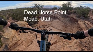
Barely intermediate, mostly easy riding, especially after you break off of the rim and make a 180 up to the mesa it really smooths out. Some fast fun sections give this trail some great flow.

Adaptive Bike Info
aMTB Blue Rating: Intermediate features and steeper terrain.

Best counter-clockwise. About a third of the way in there is a 2 foot or so drop which is moderately rollable, which may not be surmountable clockwise without a support rider or 3. Additionally, There are 2 or 3 semi off-camber spots that are questionable. Take a support rider the first time.

Trail Supporters
Local Trail Association
Traditionally Indigenous Territory

Recent Activity on Trail

Past Week
  • 2 rides
  • 12 miles average
6 Months
  • 149 rides
  • 13 miles avg distance
All
  • 1,385 rides
  • Last: Jun 21, 2026
c1c2c3c4
January
February
March
April
May
June
July
August
September
October
November
December
Status:
on Jun 3, 2026
Ideal
Avg: 4.25 (50 votes)
Your vote: 0

view (5,024)
close
3D
Trail Conditions
  • Unknown
  • Snow Groomed
  • Snow Packed
  • Snow Covered
  • Snow Cover Partial
  • Freeze/thaw Cycle
  • Icy
  • Prevalent Mud
  • Wet
  • Variable
  • Ideal
  • Dry
  • Very Dry
Trail Flow (Ridden Direction)
Trailforks scans users ridelogs to determine the most popular direction each trail is ridden. A good flowing trail network will have most trails flowing in a single direction according to their intension.
The colour categories are based on what percentage of riders are riding a trail in its intended direction.
  • > 96%
  • > 90%
  • > 80%
  • > 70%
  • > 50%
  • < 50%
  • bi-directional trail
  • no data
Trail Last Ridden
Trailforks scans ridelogs to determine the last time a trail was ridden.
  • < 2 days
  • < 1 week
  • < 2 weeks
  • < 1 month
  • < 6 months
  • > 6 months
Trail Ridden Direction
The intended direction a trail should be ridden.
  • Downhill Only
  • Downhill Primary
  • Both Directions
  • Uphill Primary
  • Uphill Only
  • One Direction
Contribute Details
Colors indicate trail is missing specified detail.
  • Description
  • Photos
  • Description & Photos
  • Videos
Trail Popularity ?
Trailforks scans ridelogs to determine which trails are ridden the most in the last 9 months. Trails are compared with nearby trails in the same city region with a possible 25 colour shades. Think of this as a heatmap, more rides = more kinetic energy = warmer colors.
  • most popular
  • popular
  • less popular
  • not popular
ATV/ORV/OHV Filter
Max Vehicle Width
inches
US Cell Coverage
Legend
cell carrier legend

Radar Time
Activity Recordings
Trailforks uses anonymized public activity data. ?
Activity Recordings
Trailforks uses anonymized public activity data. ?
Personal Heatmap
Activity Types
all / none
Options
2
Date range month
Winter Trails
Warning A routing network for winter maps does not exist. Selecting trails using the winter trails layer has been disabled.
Missing Trails
Most Popular
Least Popular
Trails are colored based on popularity. The more popular a trail is, the more red. Less popular trails trend towards green.
Jump Magnitude Heatmap
Heatmap of where riders jump on trails. Zoom in to see individual jumps, click circles to view jump details.
BC Backroad Status

Service Road Atlas is a free to use, community-driven service for viewing and creating reports on the numerous back-country service roads around B.C. and Alberta.

map legend
Slope Aspect
Direction the slope faces
Flat N NE E SE S SW W NW
Trails Deemphasized
Trails are shown in grey.
disable
Only show trails with no bike usage.
Enable
Suggested Layers
Based on selected activity type

    Save the current map location and zoom level as your default home location whenever this page is loaded.

    Save
        Directions to big-chief trailhead (38.504070, -109.714640)

        Photos

        42 more »
        32 |
        May 11, 2026 @ 4:04pm
        May 11, 2026
        99 |
        Apr 22, 2025 @ 12:29pm
        Apr 22, 2025
        95 |
        Apr 22, 2025 @ 12:29pm
        Apr 22, 2025
        92 |
        Apr 22, 2025 @ 12:29pm
        Apr 22, 2025

        Videos

        7 more »
        Scenic Views for Miles
        15:26 | 60 | Mar 7, 2026 , Moab
        Dead Horse Point Full Loop
        12:56 | 129 | Jun 30, 2025 , Moab
        Nice ride with an incredible view !!
        6:16 | 67 | May 12, 2025 , Moab
        youtuber Great Pyramid and Big Chief
        10:09 | 306 | Oct 27, 2023 , Moab

        Routes with this trail

        4.5 13 miles 675 ft 12 Loop
        > > > > > > > Back on to parking lot
        5.0 13 miles 690 ft 5 Loop
        A short ride in one of the most beautiful areas around Moab Utah! Great intermediate riding in Moab.
        3.5 12 miles 682 ft 8 Loop
        A short ride in one of the most beautiful areas around Moab Utah! Great intermediate riding in Moab.

        10 Reviews & Comments


        We hope you've been enjoying Trailforks!

        Create a FREE account to view trail comments and much more.

        • By toddTF Pro Trailforks & contributors
        • #8836 - 8,442 views

        Frequently Asked Questions About Big Chief

        Where is Big Chief located?
        Big Chief is located in Dead Horse Point, Moab, Utah, United States. It is part of the Dead Horse Point trail network. The trailhead is located at coordinates 38.50407, -109.71464.
        How hard is Big Chief?
        Big Chief is rated as Blue difficulty. The physical rating is Moderate. The average grade is 0.3%. The climb difficulty is rated Green.
        What is the elevation gain for Big Chief?
        Big Chief has 196 ft of elevation gain. The trail has 143 ft of elevation descent. The elevation ranges from 5,926 ft to 6,021 ft.
        Is Big Chief a point to point trail?
        Big Chief is not a point to point trail. The direction is Both Directions. The trail type is singletrack.

        Hit the Trail

        Open in App

        Get this trail on your phone instantly.
        open trail in app

        Download Trail

        Save to wishlist, Garmin & download.
        save the trail

        Find Related Routes

        Find routes and users activities that include this trail.
        find routes for this trail

        You must enter a description before submitting.