more stats
4,462 ft
Distance
5 ft
Climb
-611 ft
Descent
00:16:06
Avg time
-606 ft
Altitude change
1,168 ft
Altitude min
1,779 ft
Altitude max
1,774 ft
Altitude start
1,168 ft
Altitude end
-13.6%
Grade
-56.7%
Grade max
9.1%
Grade min
164 ft
Distance climb
4,298 ft
Distance down
00:16:06
Avg time

Bigguns Details

  • Activities
    • Mountain Bike
    • Hike
    • Trail Running
  • Riding Area
    Bear Mountain
    Mission, British Columbia
  • Difficulty Rating
  • Voted Difficulty
    Black Diamond (1 vote)
  • Local Popularity
    85 in Mountain Biking [+]
    • 70 in Trail Running
    • 75 in Hiking
  • Global Ranking
    #29550 in Mountain Biking [+]
    • #6402 in Trail Running
    • #7174 in Hiking
  • Trail Type
    Singletrack
  • Bike Type
    DH, AM
  • Direction
    Downhill Only
    Popular Direction Shown
  • Physical Rating
    Moderate
  • Season
    All season
  • Dogs Allowed
    Yes
  • eBike Allowed
  • TTFs on Trail
    Bridge, Rock Face, Skinny
  • Land Owner
  • OSM Way

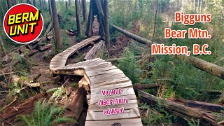
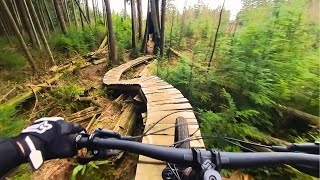
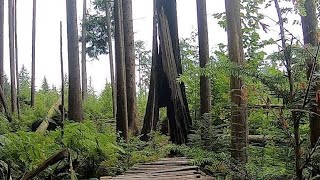
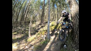
Completely natural trail with some pedaling in the middle. Flat start, steep sections, flat middle, steep sections, rolling flow, steep finish onto the road.

Access Info

To access Bigguns follow the logging road up to the old Backdoor trail. When you get near the top the road will fork with a steep climb up to the right. Follow that climb and the entrance will be found after you enter the cut block. Look for the stone piles on your right to mark the entrance.

This trail is unsanctioned.

Traditionally Indigenous Territory

Recent Activity on Trail

Past Week
  • 0 rides
  •  
6 Months
  • 18 rides
  • 9 miles avg distance
All
  • 297 rides
  • Last: Jun 27, 2026
c1c2c3c4
January
February
March
April
May
June
July
August
September
October
November
December
update trails status or condition

Bigguns Trail Reports

statusdatedescription
Jun 22, 2026 @ 3:34pm (America/Vancouver)
Jun 22, 2026
Getting a little overgrown in the middle section
Jan 21, 2026 @ 3:13pm (America/Vancouver)
Jan 21, 2026
these saws are awesome, took 5-10 min.
Nov 8, 2025 @ 1:55pm (America/Vancouver)
Nov 8, 2025
I cleared about 8 trees but one big tree in the last steep shoot, near the bottom will need a chainsaw.
Sep 21, 2025 @ 3:42pm (America/Vancouver)
Sep 21, 2025
reporter All trees cleared.
Aug 14, 2025 @ 7:07pm
Aug 14, 2025
reporter
more »
Status:
on Jun 22, 2026
Ideal
Avg: 3.7 (32 votes)
Your vote: 0

view (2,208)
close
3D
Trail Conditions
  • Unknown
  • Snow Groomed
  • Snow Packed
  • Snow Covered
  • Snow Cover Partial
  • Freeze/thaw Cycle
  • Icy
  • Prevalent Mud
  • Wet
  • Variable
  • Ideal
  • Dry
  • Very Dry
Trail Flow (Ridden Direction)
Trailforks scans users ridelogs to determine the most popular direction each trail is ridden. A good flowing trail network will have most trails flowing in a single direction according to their intension.
The colour categories are based on what percentage of riders are riding a trail in its intended direction.
  • > 96%
  • > 90%
  • > 80%
  • > 70%
  • > 50%
  • < 50%
  • bi-directional trail
  • no data
Trail Last Ridden
Trailforks scans ridelogs to determine the last time a trail was ridden.
  • < 2 days
  • < 1 week
  • < 2 weeks
  • < 1 month
  • < 6 months
  • > 6 months
Trail Ridden Direction
The intended direction a trail should be ridden.
  • Downhill Only
  • Downhill Primary
  • Both Directions
  • Uphill Primary
  • Uphill Only
  • One Direction
Contribute Details
Colors indicate trail is missing specified detail.
  • Description
  • Photos
  • Description & Photos
  • Videos
Trail Popularity ?
Trailforks scans ridelogs to determine which trails are ridden the most in the last 9 months. Trails are compared with nearby trails in the same city region with a possible 25 colour shades. Think of this as a heatmap, more rides = more kinetic energy = warmer colors.
  • most popular
  • popular
  • less popular
  • not popular
ATV/ORV/OHV Filter
Max Vehicle Width
inches
US Cell Coverage
Legend
cell carrier legend

Radar Time
Activity Recordings
Trailforks uses anonymized public activity data. ?
Activity Recordings
Trailforks uses anonymized public activity data. ?
Personal Heatmap
Activity Types
all / none
Options
2
Date range month
Winter Trails
Warning A routing network for winter maps does not exist. Selecting trails using the winter trails layer has been disabled.
Missing Trails
Most Popular
Least Popular
Trails are colored based on popularity. The more popular a trail is, the more red. Less popular trails trend towards green.
Jump Magnitude Heatmap
Heatmap of where riders jump on trails. Zoom in to see individual jumps, click circles to view jump details.
BC Backroad Status

Service Road Atlas is a free to use, community-driven service for viewing and creating reports on the numerous back-country service roads around B.C. and Alberta.

map legend
Slope Aspect
Direction the slope faces
Flat N NE E SE S SW W NW
Trails Deemphasized
Trails are shown in grey.
disable
Only show trails with no bike usage.
Enable
Suggested Layers
Based on selected activity type

    Save the current map location and zoom level as your default home location whenever this page is loaded.

    Save
        Directions to bigguns trailhead (49.193790, -122.296920)

        Photos

        91 more »
        82 |
        Jan 30, 2024 @ 1:45pm
        Jan 30, 2024
        86 |
        Jan 30, 2024 @ 1:44pm
        Jan 30, 2024
        91 |
        Jan 30, 2024 @ 1:41pm
        Jan 30, 2024
        83 |
        Jan 30, 2024 @ 1:37pm
        Jan 30, 2024

        Videos

        14 more »
        youtuber Bit By Bigguns! - *viewer discretion advised*...
        7:34 | 1172 | Apr 30, 2021 , Mission
        This Mountain Is A True PNW Gem
        22:47 | 174 | Aug 11, 2024 , Mission
        Welcome to the gun show
        22:18 | 417 | Sep 8, 2020 , Mission
        Bear Mountain Big Guns
        10:10 | 531 | Jul 29, 2020 , Mission

        Routes with this trail

        4.0 15 miles 3,260 ft 28 Loop
        Two Loops: one on Bear and one on Red. I rode Bear first, but you could do Red first as it is a little...
        9 miles 2,216 ft 13
        Fraser Valley Bear Classic Fraser Valley Relive Your Ride For other ride suggestions for this and other...
        12 miles 3,153 ft 14
        Fraser Valley Bear Epic Fraser Valley Relive Your Ride For other ride suggestions for this and other...

        Trail Products

        14 Reviews & Comments


        We hope you've been enjoying Trailforks!

        Create a FREE account to view trail comments and much more.

        Nearby Trails

        • #333 - 9,190 views

        Frequently Asked Questions About Bigguns

        Where is Bigguns located?
        Bigguns is located in Bear Mountain, Mission, British Columbia, Canada. It is part of the Bear Mountain trail network. The trailhead is located at coordinates 49.19379, -122.29692.
        How hard is Bigguns?
        Bigguns is rated as Black Diamond difficulty. The physical rating is Moderate. The average grade is 13.6%.
        What is the elevation gain for Bigguns?
        Bigguns has 5 ft of elevation gain. The trail has 611 ft of elevation descent. The elevation ranges from 1,168 ft to 1,779 ft.
        Is Bigguns a point to point trail?
        Yes, Bigguns is a point to point trail. The direction is Downhill Only. The trail type is singletrack.

        Hit the Trail

        Open in App

        Get this trail on your phone instantly.
        open trail in app

        Download Trail

        Save to wishlist, Garmin & download.
        save the trail

        Find Related Routes

        Find routes and users activities that include this trail.
        find routes for this trail

        You must enter a description before submitting.