more stats
3,940 ft
Distance
-696 ft
Descent
00:18:08
Avg time
-694 ft
Altitude change
4,982 ft
Altitude min
5,680 ft
Altitude max
5,680 ft
Altitude start
4,987 ft
Altitude end
-17.6%
Grade
-65.5%
Grade max
2.4%
Grade min
112 ft
Distance climb
3,780 ft
Distance down
46 ft
Distance flat
00:18:08
Avg time

Billy Dog Details

  • Activities
    • Mountain Bike
    • E-Bike
  • Riding Area
    Moose Mountain
    Bragg Creek, Alberta
  • Difficulty Rating
  • Voted Difficulty
    Black Diamond (1 vote)
  • Local Popularity
    85 in Mountain Biking [+]
    • 95 in E-Biking
  • Global Ranking
    #35009 in Mountain Biking [+]
    • #40358 in E-Biking
  • Trail Type
    Singletrack
  • Bike Type
    DH
  • Direction
    Downhill Only
    Popular Direction Shown
  • Physical Rating
    Hard
  • Dogs Allowed
    Yes
  • eBike Allowed
    Yes up to Class 1

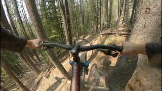
Billy Dog starts off on a steep pitch where a healthy dose of benching and berms will keep you in line and on track as a warm up for the steep, tight, and narrow portion that’s to come. TTF’s are not part of the first half of this trail and any manmade features come in the form of short bridges and benching to help sustain the line. Brake levers bent and shoulders bruised you’ll pop out into an opening that will give you a nice mountain view to enjoy while you bandage your knuckles from the abuse they’ve taken from those trees that just seem to pop out from nowhere. At this point the trail starts to ease into a more open and faster part of the forest. A few more somewhat tight turns through the forest and you’ll be able to open the throttle and catch some sweet air out of the trees and into the light of the cutline. Back into the trees the steeps are over and you’ll be able to step on the gas for a dozen or more TTF’s in the ending part of the trail. One more pitch requires respect as it is steep and a fall over the berm here will put you much too far away from your bike than you would like. One more switchback, a few more TTF’s, twists and turns, and you’re done. Cross Canyon Creek, hit the road and turn left

Watch for continued buffing and additional trail features on Billy Dog throughout 2009!

source: mmbts
Access Info

Drive or pedal to the crest of the hill just after the 4km mark on the Moose Mountain road. If driving, it will be safest to park on the branch road around the 4km mark as there is no decent pullout for vehicles at the crest of the hill. Be conscious to not block access to the Shell lease and of your hot exhaust in the deep grass Once you crest the hill, continue another 50-75 meters further up the road and watch for the trailhead on your left. Billy Dog ends at the Canyon Creek road, where you turn left towards the Ing’s mine parking lot to complete your loop or meet up with your vehicle. Billy Dog will take the average rider around 25-35 minutes complete from vehicle to vehicle if ridden straight through from top to bottom.

Local Trail Association

Recent Activity on Trail

Past Week
  • 4 rides
  • 34.8 km average
6 Months
  • 32 rides
  • 22.1 km avg distance
All
  • 345 rides
  • Last: Jun 14, 2026
c1c2c3c4
January
February
March
April
May
June
July
August
September
October
November
December
update trails status or condition

Billy Dog Trail Reports

Status:
on Jun 14, 2026
Ideal
Avg: 4.22 (17 votes)
Your vote: 0

view (2,268)
close
3D
Trail Conditions
  • Unknown
  • Snow Groomed
  • Snow Packed
  • Snow Covered
  • Snow Cover Partial
  • Freeze/thaw Cycle
  • Icy
  • Prevalent Mud
  • Wet
  • Variable
  • Ideal
  • Dry
  • Very Dry
Trail Flow (Ridden Direction)
Trailforks scans users ridelogs to determine the most popular direction each trail is ridden. A good flowing trail network will have most trails flowing in a single direction according to their intension.
The colour categories are based on what percentage of riders are riding a trail in its intended direction.
  • > 96%
  • > 90%
  • > 80%
  • > 70%
  • > 50%
  • < 50%
  • bi-directional trail
  • no data
Trail Last Ridden
Trailforks scans ridelogs to determine the last time a trail was ridden.
  • < 2 days
  • < 1 week
  • < 2 weeks
  • < 1 month
  • < 6 months
  • > 6 months
Trail Ridden Direction
The intended direction a trail should be ridden.
  • Downhill Only
  • Downhill Primary
  • Both Directions
  • Uphill Primary
  • Uphill Only
  • One Direction
Contribute Details
Colors indicate trail is missing specified detail.
  • Description
  • Photos
  • Description & Photos
  • Videos
Trail Popularity ?
Trailforks scans ridelogs to determine which trails are ridden the most in the last 9 months. Trails are compared with nearby trails in the same city region with a possible 25 colour shades. Think of this as a heatmap, more rides = more kinetic energy = warmer colors.
  • most popular
  • popular
  • less popular
  • not popular
ATV/ORV/OHV Filter
Max Vehicle Width
inches
US Cell Coverage
Legend
cell carrier legend

Radar Time
Activity Recordings
Trailforks uses anonymized public activity data. ?
Activity Recordings
Trailforks uses anonymized public activity data. ?
Personal Heatmap
Activity Types
all / none
Options
2
Date range month
Winter Trails
Warning A routing network for winter maps does not exist. Selecting trails using the winter trails layer has been disabled.
Missing Trails
Most Popular
Least Popular
Trails are colored based on popularity. The more popular a trail is, the more red. Less popular trails trend towards green.
Jump Magnitude Heatmap
Heatmap of where riders jump on trails. Zoom in to see individual jumps, click circles to view jump details.
BC Backroad Status

Service Road Atlas is a free to use, community-driven service for viewing and creating reports on the numerous back-country service roads around B.C. and Alberta.

map legend
Slope Aspect
Direction the slope faces
Flat N NE E SE S SW W NW
Trails Deemphasized
Trails are shown in grey.
disable
Only show trails with no bike usage.
Enable
Suggested Layers
Based on selected activity type

    Save the current map location and zoom level as your default home location whenever this page is loaded.

    Save
        Directions to billy-dog trailhead (50.897400, -114.751730)

        Photos

        44 more »
        221 |
        Oct 8, 2021 @ 9:46pm
        Oct 8, 2021
        294 |
        Jul 20, 2021 @ 7:51pm
        Jul 20, 2021
        241 |
        Jul 20, 2021 @ 7:51pm
        Jul 20, 2021
        263 |
        Jul 20, 2021 @ 7:51pm
        Jul 20, 2021

        Videos

        23 more »
        youtuber Full Top to Bottom Billy Dog POV Footage |...
        7:04 | 629 | Nov 1, 2023 , Bragg Creek
        Billy Dog | Moose Mountain MTB
        7:16 | 375 | Oct 8, 2023 , Bragg Creek
        Billy Dog (Moose Mountain)
        4:24 | 778 | Sep 6, 2022 , Bragg Creek
        Billy Dog Moose Mountain AB (All TTFS)
        4:46 | 819 | Aug 19, 2021 , Bragg Creek

        Routes with this trail

        12 miles 2,467 ft 4
        Stage from Ings, Out Up RoS in two stages Up RoH Down Back via Canyon Creek
        9 miles 1,644 ft 4
        A challenging loop includes two very different trails, the blue flow of 7-27 and the chunky tech of Billy Dog.
        4.0 11 miles 1,991 ft 17 Loop
        Moose mtn - 7-27 loop

        3 Reviews & Comments


        We hope you've been enjoying Trailforks!

        Create a FREE account to view trail comments and much more.

        Frequently Asked Questions About Billy Dog

        Where is Billy Dog located?
        Billy Dog is located in Moose Mountain, Bragg Creek, Alberta, Canada. It is part of the Moose Mountain trail network. The trailhead is located at coordinates 50.8974, -114.75173.
        How hard is Billy Dog?
        Billy Dog is rated as Black Diamond difficulty. The physical rating is Hard. The average grade is 17.6%.
        What is the elevation gain for Billy Dog?
        The trail has 212 m of elevation descent. The elevation ranges from 1,519 m to 1,731 m.
        Is Billy Dog a point to point trail?
        Yes, Billy Dog is a point to point trail. The direction is Downhill Only. The trail type is singletrack.

        Hit the Trail

        Open in App

        Get this trail on your phone instantly.
        open trail in app

        Download Trail

        Save to wishlist, Garmin & download.
        save the trail

        Find Related Routes

        Find routes and users activities that include this trail.
        find routes for this trail

        You must enter a description before submitting.