more stats
1.3 miles
Distance
58 ft
Climb
-1,478 ft
Descent
00:08:24
Avg time
-1,420 ft
Altitude change
951 ft
Altitude min
2,371 ft
Altitude max
2,371 ft
Altitude start
951 ft
Altitude end
-20.082%
Grade
-67.578%
Grade max
32.684%
Grade min
555 ft
Distance climb
1 mile
Distance down
164 ft
Distance flat
00:08:24
Avg time

Biondo Details

  • Activities
    • Mountain Bike
    • Hike
    • Trail Running
  • Riding Area
  • Difficulty Rating
  • Local Popularity
    75 in Mountain Biking [+]
    • 5 in Trail Running
    • 5 in Hiking
  • Global Ranking
    #47861 in Mountain Biking [+]
    • #127291 in Trail Running
    • #120494 in Hiking
  • Trail Type
    Singletrack
  • Bike Type
    DH, AM
  • Direction
    Downhill Primary
    Popular Direction Shown
  • Dogs Allowed
    Yes
  • TTFs on Trail
    Drop, Jump

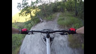
Singletrack su terra divertente e abbastanza scorrevole, un po piu impegnativa la prima parte dopo il tratto in contropendenza, qualche rampa e drop comunque evitabili.

Access Info

Una volta arrivati allo spiazzo da dove partono i trail seguendo la risalita monteduro si possono vedere i vari cartelli di indicazione, il biondo si trova di fronte, qualche metro avanti.

Recent Activity on Trail

Past Week
  • 0 rides
  •  
6 Months
  • 1 rides
  • 11 miles avg distance
All
  • 43 rides
  • Last: Jun 6, 2026
c1c2c3c4
January
February
March
April
May
June
July
August
September
October
November
December
update trails status or condition

Biondo Trail Reports

statusdatedescription
Nov 10, 2025 @ 8:51am (Europe/Rome)
Nov 9, 2025
Terreno molto buono per la stagione, più umido e un po' scivoloso in basso, nella parte finale. Negli ultimi anni si è scavata molto la parte...
Dec 27, 2023 @ 9:04am
Dec 27, 2023
Asciutto e pulito. Sempre più scavato dopo il ripido
Oct 15, 2023 @ 6:55am
Oct 15, 2023
Sep 22, 2023 @ 10:52pm
Sep 22, 2023
Tronco di pino rimosso
Aug 27, 2023 @ 5:03am
Aug 27, 2023
Tronco di pino caduto sulla carrai all'altezza del collegamento proveniente da Sassaia, appena prima di ributtarsi a dx nel bosco.
more »
Status:
on Nov 10, 2025
Variable
Avg: 4.26 (5 votes)
Your vote: 0

view (218)
close
3D
Trail Conditions
  • Unknown
  • Snow Groomed
  • Snow Packed
  • Snow Covered
  • Snow Cover Partial
  • Freeze/thaw Cycle
  • Icy
  • Prevalent Mud
  • Wet
  • Variable
  • Ideal
  • Dry
  • Very Dry
Trail Flow (Ridden Direction)
Trailforks scans users ridelogs to determine the most popular direction each trail is ridden. A good flowing trail network will have most trails flowing in a single direction according to their intension.
The colour categories are based on what percentage of riders are riding a trail in its intended direction.
  • > 96%
  • > 90%
  • > 80%
  • > 70%
  • > 50%
  • < 50%
  • bi-directional trail
  • no data
Trail Last Ridden
Trailforks scans ridelogs to determine the last time a trail was ridden.
  • < 2 days
  • < 1 week
  • < 2 weeks
  • < 1 month
  • < 6 months
  • > 6 months
Trail Ridden Direction
The intended direction a trail should be ridden.
  • Downhill Only
  • Downhill Primary
  • Both Directions
  • Uphill Primary
  • Uphill Only
  • One Direction
Contribute Details
Colors indicate trail is missing specified detail.
  • Description
  • Photos
  • Description & Photos
  • Videos
Trail Popularity ?
Trailforks scans ridelogs to determine which trails are ridden the most in the last 9 months. Trails are compared with nearby trails in the same city region with a possible 25 colour shades. Think of this as a heatmap, more rides = more kinetic energy = warmer colors.
  • most popular
  • popular
  • less popular
  • not popular
ATV/ORV/OHV Filter
Max Vehicle Width
inches
US Cell Coverage
Legend
cell carrier legend

Radar Time
Activity Recordings
Trailforks uses anonymized public activity data. ?
Activity Recordings
Trailforks uses anonymized public activity data. ?
Personal Heatmap
Activity Types
all / none
Options
2
Date range month
Winter Trails
Warning A routing network for winter maps does not exist. Selecting trails using the winter trails layer has been disabled.
Missing Trails
Most Popular
Least Popular
Trails are colored based on popularity. The more popular a trail is, the more red. Less popular trails trend towards green.
Jump Magnitude Heatmap
Heatmap of where riders jump on trails. Zoom in to see individual jumps, click circles to view jump details.
BC Backroad Status

Service Road Atlas is a free to use, community-driven service for viewing and creating reports on the numerous back-country service roads around B.C. and Alberta.

map legend
Slope Aspect
Direction the slope faces
Flat N NE E SE S SW W NW
Trails Deemphasized
Trails are shown in grey.
disable
Only show trails with no bike usage.
Enable
Suggested Layers
Based on selected activity type

    Save the current map location and zoom level as your default home location whenever this page is loaded.

    Save
        Directions to biondo-75416 trailhead (44.536510, 10.538780)

        Photos

        5 more »
        134 |
        Nov 15, 2016 @ 2:07pm
        Nov 15, 2016
        133 |
        Nov 15, 2016 @ 1:56pm
        Nov 15, 2016
        105 |
        Nov 15, 2016 @ 1:48pm
        Nov 15, 2016
        125 |
        Nov 15, 2016 @ 1:46pm
        Nov 15, 2016

        Videos

        1 more »
        Biondo - Front Enduro al MTB Monte Duro -...
        7:41 | 258 | Aug 1, 2022 , Viano

        6 Reviews & Comments


        We hope you've been enjoying Trailforks!

        Create a FREE account to view trail comments and much more.

        • By andreabraglia & contributors
        • #75416 - 3,040 views

        Frequently Asked Questions About Biondo

        Where is Biondo located?
        Biondo is located in Monteduro Freeride Paradise, Viano, Italy. It is part of the Monteduro Freeride Paradise trail network. The trailhead is located at coordinates 44.53651, 10.53878.
        How hard is Biondo?
        Biondo is rated as Blue difficulty. The average grade is 20.082%.
        What is the elevation gain for Biondo?
        Biondo has 18 m of elevation gain. The trail has 451 m of elevation descent. The elevation ranges from 290 m to 723 m.
        Is Biondo a point to point trail?
        Biondo is not a point to point trail. The direction is Downhill Primary. The trail type is singletrack.

        Hit the Trail

        Open in App

        Get this trail on your phone instantly.
        open trail in app

        Download Trail

        Save to wishlist, Garmin & download.
        save the trail

        Find Related Routes

        Find routes and users activities that include this trail.
        find routes for this trail

        You must enter a description before submitting.