more stats
9.6 miles
Distance
1,838 ft
Climb
-3,892 ft
Descent
02:29:37
Avg time
-2,054 ft
Altitude change
9,024 ft
Altitude min
12,837 ft
Altitude max
11,078 ft
Altitude start
9,022 ft
Altitude end
-4%
Grade
-80.9%
Grade max
58.4%
Grade min
3 miles
Distance climb
6 miles
Distance down
830 ft
Distance flat
02:29:37
Avg time

Black Bear Road Details

  • Activities
    • Mountain Bike
    • E-Bike
    • Gravel Bike
    • Hike
    • Trail Running
    • Dirtbike/Moto
    • ATV/ORV/OHV
  • Riding Area
    Telluride
    , Colorado
  • Ref Number
    #648
  • Difficulty Rating
  • Local Popularity
    40 in Mountain Biking [+]
    • 55 in E-Biking
    • 5 in Trail Running
    • 5 in Hiking
    • 95 in Dirtbiking
    • 5 in ATVing/Offroading
  • Global Ranking
    #64737 in Mountain Biking [+]
    • #71134 in Hiking
  • Trail Type
    Dirt/Gravel Road
  • Bike Type
    AM, XC, Gravel
  • Direction
    Both Directions
  • Climb Difficulty
    Black Diamond
  • Physical Rating
    Hard
  • Trail Visibility
    Always easy to follow
  • Dogs Allowed
    Yes
  • eBike Allowed
    Yes up to Class 1

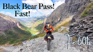
This OHV route offers a very technical trail that is not for inexperienced drivers or riders. While most of the road is moderate in difficulty. the mile-long stretch of steep switchbacks on the Telluride side above Bridal Veil Falls is rated as difficult. A high clearance, short wheel base, four wheel drive vehicle is strongly recommended for this section of the road. The road starts from State Highway 550 at Red Mountain Pass (signed as Forest Road #823) and climbs quickly to Black Bear Pass at 3.2 miles. There is ample room for parking at the Pass where there are views into Ingram Basin. The road then descends into Ingram Basin, past Ingram Lake and the Black Bear Mine. At approx. 5.6 miles the road begins descending the "Steps" which are comprised of a series of steep, technical rock steps. From this point down to the Bridal Veil Powerplant (approx 1 mile), the road is one-way only. Once down the "Steps", the road continues past Ingram Falls, making extremely tight, narrow switchbacks until it reaches the Bridal Veil Falls Powerplant. Driving, riding, or walking down this section of the road is not only a thrill; it also offers spectacular views of the Telluride Valley, Ingram Fall, and Bridal Veil Falls.

Local Trail Association
Traditionally Indigenous Territory

Recent Activity on Trail

Past Week
  • 0 rides
  •  
6 Months
  • 0 rides
  •  
All
  • 2 rides
  • Last: Sep 24, 2025
c1c2c3c4
January
February
March
April
May
June
July
August
September
October
November
December
update trails status or condition

Black Bear Road Trail Reports

statusdatedescription
Jun 13, 2022 @ 6:21am
Jun 13, 2022
Aug 3, 2019 @ 9:42pm
Aug 3, 2019
Closed until the 9th to all foot, bike and motor traffic while work is being done to repair damage from flooding, slides.
more »
Status:
on Jun 13, 2022
Variable
Avg: 4.11 (3 votes)
Your vote: 0

view (51)
close
3D
Trail Conditions
  • Unknown
  • Snow Groomed
  • Snow Packed
  • Snow Covered
  • Snow Cover Partial
  • Freeze/thaw Cycle
  • Icy
  • Prevalent Mud
  • Wet
  • Variable
  • Ideal
  • Dry
  • Very Dry
Trail Flow (Ridden Direction)
Trailforks scans users ridelogs to determine the most popular direction each trail is ridden. A good flowing trail network will have most trails flowing in a single direction according to their intension.
The colour categories are based on what percentage of riders are riding a trail in its intended direction.
  • > 96%
  • > 90%
  • > 80%
  • > 70%
  • > 50%
  • < 50%
  • bi-directional trail
  • no data
Trail Last Ridden
Trailforks scans ridelogs to determine the last time a trail was ridden.
  • < 2 days
  • < 1 week
  • < 2 weeks
  • < 1 month
  • < 6 months
  • > 6 months
Trail Ridden Direction
The intended direction a trail should be ridden.
  • Downhill Only
  • Downhill Primary
  • Both Directions
  • Uphill Primary
  • Uphill Only
  • One Direction
Contribute Details
Colors indicate trail is missing specified detail.
  • Description
  • Photos
  • Description & Photos
  • Videos
Trail Popularity ?
Trailforks scans ridelogs to determine which trails are ridden the most in the last 9 months. Trails are compared with nearby trails in the same city region with a possible 25 colour shades. Think of this as a heatmap, more rides = more kinetic energy = warmer colors.
  • most popular
  • popular
  • less popular
  • not popular
ATV/ORV/OHV Filter
Max Vehicle Width
inches
US Cell Coverage
Legend
cell carrier legend

Radar Time
Activity Recordings
Trailforks uses anonymized public activity data. ?
Activity Recordings
Trailforks uses anonymized public activity data. ?
Personal Heatmap
Activity Types
all / none
Options
2
Date range month
Winter Trails
Warning A routing network for winter maps does not exist. Selecting trails using the winter trails layer has been disabled.
Missing Trails
Most Popular
Least Popular
Trails are colored based on popularity. The more popular a trail is, the more red. Less popular trails trend towards green.
Jump Magnitude Heatmap
Heatmap of where riders jump on trails. Zoom in to see individual jumps, click circles to view jump details.
BC Backroad Status

Service Road Atlas is a free to use, community-driven service for viewing and creating reports on the numerous back-country service roads around B.C. and Alberta.

map legend
Slope Aspect
Direction the slope faces
Flat N NE E SE S SW W NW
Trails Deemphasized
Trails are shown in grey.
disable
Only show trails with no bike usage.
Enable
Suggested Layers
Based on selected activity type

    Save the current map location and zoom level as your default home location whenever this page is loaded.

    Save
        Directions to black-bear-road trailhead (37.896820, -107.713390)

        Photos

        2 more »
        60 |
        Aug 1, 2024 @ 12:08pm
        Aug 1, 2024
        48 |
        Aug 1, 2024 @ 9:13am
        Aug 1, 2024

        Videos

        2 more »
        Quick Rip Up and Over Black Bear Pass! Fe...
        28:53 | 42 | Oct 27, 2025 , Telluride
        The BEAR was still hibernating!
        7:11 | 327 | Jun 14, 2022 , Telluride

        Reviews / Comments

        No reviews yet, be the first to write a review or ask a question.
        Use trail reports to comment on trail conditions.


        We hope you've been enjoying Trailforks!

        Create a FREE account to view trail comments and much more.

        • By toddTF Pro Trailforks & contributors
        • #196843 - 3,344 views

        Frequently Asked Questions About Black Bear Road

        Where is Black Bear Road located?
        Black Bear Road is located in Telluride, Colorado, United States. It is part of the Telluride trail network. The trailhead is located at coordinates 37.89682, -107.71339.
        What is the elevation gain for Black Bear Road?
        Black Bear Road has 1,838 ft of elevation gain. The trail has 3,892 ft of elevation descent. The elevation ranges from 9,024 ft to 12,837 ft.
        Is Black Bear Road a point to point trail?
        Black Bear Road is not a point to point trail. The direction is Both Directions. The trail type is dirt/gravel road.
        How long is Black Bear Road?
        Black Bear Road is 9.6 miles long. The trail type is dirt/gravel road.

        Hit the Trail

        Open in App

        Get this trail on your phone instantly.
        open trail in app

        Download Trail

        Save to wishlist, Garmin & download.
        save the trail

        Find Related Routes

        Find routes and users activities that include this trail.
        find routes for this trail

        You must enter a description before submitting.