more stats
5.0 miles
Distance
237 ft
Climb
-2,732 ft
Descent
01:10:21
Avg time
-2,494 ft
Altitude change
6,489 ft
Altitude min
9,220 ft
Altitude max
8,997 ft
Altitude start
6,503 ft
Altitude end
-9.5%
Grade
-38%
Grade max
21.8%
Grade min
3,038 ft
Distance climb
4 miles
Distance down
853 ft
Distance flat
01:10:21
Avg time

Black Canyon Details

  • Activities
    • Mountain Bike
    • Hike
    • Trail Running
  • Riding Area
    Teton Pass
    Wilson, Wyoming
  • Difficulty Rating
  • Voted Difficulty
    Blue (3 votes)
  • Local Popularity
    65 in Mountain Biking [+]
    • 70 in Trail Running
    • 60 in Hiking
  • Global Ranking
    #37724 in Mountain Biking [+]
    • #60980 in Trail Running
    • #61854 in Hiking
  • Trail Type
    Singletrack
  • Bike Type
    AM, XC
  • Direction
    Downhill Primary
    Popular Direction Shown
  • Climb Difficulty
    Black Diamond
  • Physical Rating
    Hard
  • Trail Visibility
    Always easy to follow
  • Dogs Allowed
    Yes
  • eBike Allowed
  • Land Owner

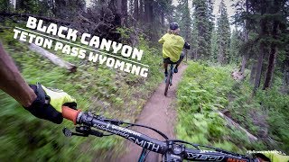
Fun single track with lots of high speed sections. Most people ride down this trail but it is multi use and gets uphill traffic as well. Keep an eye out for hikers and equestrians particularly near the bottom.

Access Info

This trail can be accessed from the Trail Creek or Teton Pass Trailheads.

Trail Supporters
Local Trail Association
Traditionally Indigenous Territory

Recent Activity on Trail

Past Week
  • 1 rides
  • 10 miles average
6 Months
  • 3 rides
  • 18 miles avg distance
All
  • 161 rides
  • Last: Jun 17, 2026
c1c2c3c4
January
February
March
April
May
June
July
August
September
October
November
December
update trails status or condition

Black Canyon Trail Reports

statusdatedescription
Apr 23, 2026 @ 9:41am (America/Denver)
Apr 23, 2026
Mar 20, 2026 @ 12:18pm (America/Denver)
Mar 20, 2026
Tread Lightly. Conditions will be updated throughout the spring.
Mar 20, 2026 @ 12:16pm (America/Denver)
Mar 20, 2026
Conditions will be updated throughout the spring.
Sep 8, 2025 @ 8:01am
Sep 8, 2025
Getting dusty and braking bumps at the top
Jun 21, 2025 @ 7:19pm
Jun 21, 2025
more »
Status:
on Apr 23, 2026
Snow Covered
Avg: 4.32 (23 votes)
Your vote: 0

view (908)
close
3D
Trail Conditions
  • Unknown
  • Snow Groomed
  • Snow Packed
  • Snow Covered
  • Snow Cover Partial
  • Freeze/thaw Cycle
  • Icy
  • Prevalent Mud
  • Wet
  • Variable
  • Ideal
  • Dry
  • Very Dry
Trail Flow (Ridden Direction)
Trailforks scans users ridelogs to determine the most popular direction each trail is ridden. A good flowing trail network will have most trails flowing in a single direction according to their intension.
The colour categories are based on what percentage of riders are riding a trail in its intended direction.
  • > 96%
  • > 90%
  • > 80%
  • > 70%
  • > 50%
  • < 50%
  • bi-directional trail
  • no data
Trail Last Ridden
Trailforks scans ridelogs to determine the last time a trail was ridden.
  • < 2 days
  • < 1 week
  • < 2 weeks
  • < 1 month
  • < 6 months
  • > 6 months
Trail Ridden Direction
The intended direction a trail should be ridden.
  • Downhill Only
  • Downhill Primary
  • Both Directions
  • Uphill Primary
  • Uphill Only
  • One Direction
Contribute Details
Colors indicate trail is missing specified detail.
  • Description
  • Photos
  • Description & Photos
  • Videos
Trail Popularity ?
Trailforks scans ridelogs to determine which trails are ridden the most in the last 9 months. Trails are compared with nearby trails in the same city region with a possible 25 colour shades. Think of this as a heatmap, more rides = more kinetic energy = warmer colors.
  • most popular
  • popular
  • less popular
  • not popular
ATV/ORV/OHV Filter
Max Vehicle Width
inches
US Cell Coverage
Legend
cell carrier legend

Radar Time
Activity Recordings
Trailforks uses anonymized public activity data. ?
Activity Recordings
Trailforks uses anonymized public activity data. ?
Personal Heatmap
Activity Types
all / none
Options
2
Date range month
Winter Trails
Warning A routing network for winter maps does not exist. Selecting trails using the winter trails layer has been disabled.
Missing Trails
Most Popular
Least Popular
Trails are colored based on popularity. The more popular a trail is, the more red. Less popular trails trend towards green.
Jump Magnitude Heatmap
Heatmap of where riders jump on trails. Zoom in to see individual jumps, click circles to view jump details.
BC Backroad Status

Service Road Atlas is a free to use, community-driven service for viewing and creating reports on the numerous back-country service roads around B.C. and Alberta.

map legend
Slope Aspect
Direction the slope faces
Flat N NE E SE S SW W NW
Trails Deemphasized
Trails are shown in grey.
disable
Only show trails with no bike usage.
Enable
Suggested Layers
Based on selected activity type

    Save the current map location and zoom level as your default home location whenever this page is loaded.

    Save
        Directions to black-canyon trailhead (43.482770, -110.955520)

        Photos

        57 more »
        282 |
        Jul 24, 2018 @ 9:33pm
        Jul 24, 2018
        230 |
        Jul 24, 2018 @ 9:12pm
        Jul 24, 2018
        93 |
        Aug 13, 2023 @ 6:14pm
        Aug 13, 2023
        79 |
        Aug 13, 2023 @ 6:13pm
        Aug 13, 2023

        Videos

        4 more »
        youtuber Turn Clinic on Black Canyon | Teton Pass, Wyoming
        5:25 | 1628 | Jan 26, 2018 , Wilson
        youtuber Black Canyon Trail at Teton Pass!
        16:10 | 462 | Aug 11, 2020 , Wilson
        Riding Black Canyon Trail near the Teton Pass
        15:48 | 588 | Aug 18, 2018 , Wilson
        Shredding on Black Canyon / Teton Pass
        0:00 | 209 | Jul 15, 2018 , Wilson

        Routes with this trail

        25 miles 3,632 ft 23 Shuttled
        Shuttle Ride Start at the top of Teton Pass head out on towards . Saddle up and get ready for , this is...
        33 miles 6,163 ft 23
        A variation from the existing Tour de Teton Pass, but all on dirt and no shuttle.

        8 Reviews & Comments


        We hope you've been enjoying Trailforks!

        Create a FREE account to view trail comments and much more.

        • By toddTF Pro Trailforks & contributors
        • #23872 - 11,322 views

        Frequently Asked Questions About Black Canyon

        Where is Black Canyon located?
        Black Canyon is located in Teton Pass, Wilson, Wyoming, United States. It is part of the Teton Pass trail network. The trailhead is located at coordinates 43.48277, -110.95552.
        How hard is Black Canyon?
        Black Canyon is rated as Blue difficulty. The physical rating is Hard. The average grade is 9.5%. The climb difficulty is rated Black Diamond.
        What is the elevation gain for Black Canyon?
        Black Canyon has 237 ft of elevation gain. The trail has 2,732 ft of elevation descent. The elevation ranges from 6,489 ft to 9,220 ft.
        Is Black Canyon a point to point trail?
        Black Canyon is not a point to point trail. The direction is Downhill Primary. The trail type is singletrack.

        Hit the Trail

        Open in App

        Get this trail on your phone instantly.
        open trail in app

        Download Trail

        Save to wishlist, Garmin & download.
        save the trail

        Find Related Routes

        Find routes and users activities that include this trail.
        find routes for this trail

        You must enter a description before submitting.