more stats
1,457 ft
Distance
-312 ft
Descent
00:03:05
Avg time
-312 ft
Altitude change
846 ft
Altitude min
1,158 ft
Altitude max
1,158 ft
Altitude start
846 ft
Altitude end
-21.4%
Grade
-57.4%
Grade max
-3%
Grade min
1,440 ft
Distance down
00:03:05
Avg time

Black Grouse Details

  • Activities
    • Mountain Bike
    • E-Bike
  • Riding Area
    Drumtochty
    Laurencekirk
  • Difficulty Rating
  • Local Popularity
    80 in Mountain Biking [+]
    • 85 in E-Biking
  • Global Ranking
    #80202 in Mountain Biking [+]
    • #33250 in E-Biking
  • Trail Type
    Singletrack
  • Bike Type
    AM
  • Direction
    One Direction
    Popular Direction Shown
  • Trail Visibility
    Always easy to follow
  • eBike Allowed
    Yes up to Class 1

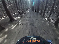
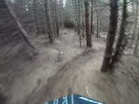
Start as per Spare Ribs or at the remains of Smart's Cairn with Rat Race.nnBoth start options lead on to an open clearing as the trail threads its way over a number of tricky root steps.nnAs the trail enters the thicker spruce forest, be wary of a large, polished, off camber root.nnThe trail traverses left for a short length before turning right and continuing down a long, straight, steep runnel, with some line choice.nnThis section ends at a terrace, where most riders continue straight down, via a small step to the fire road.

This trail is unsanctioned.

Recent Activity on Trail

Past Week
  • 0 rides
  •  
6 Months
  • 5 rides
  • 16 miles avg distance
All
  • 40 rides
  • Last: Jun 10, 2026
c1c2c3c4
January
February
March
April
May
June
July
August
September
October
November
December
update trails status or condition

Black Grouse Trail Reports

statusdatedescription
May 19, 2026 @ 6:28am (Europe/London)
May 18, 2026
A tree is progressively hanging over the start of the trail. Branches have been cut away to allow clear access to the trail.
May 17, 2026 @ 11:14am (Europe/London)
May 17, 2026
Fast and straight down - route 1.
May 10, 2025 @ 10:05am
May 10, 2025
Mar 17, 2025 @ 4:29pm
Mar 17, 2025
Ideal. Proper steep trail but running well.
Feb 8, 2025 @ 11:51pm
Feb 8, 2025
Another trees had come down across the start of the trail where it leaves the Spare Ribs access. Now removed.
more »
Status:
on May 19, 2026
Ideal
Avg: 3.86 (2 votes)
Your vote: 0

view (341)
close
3D
Trail Conditions
  • Unknown
  • Snow Groomed
  • Snow Packed
  • Snow Covered
  • Snow Cover Partial
  • Freeze/thaw Cycle
  • Icy
  • Prevalent Mud
  • Wet
  • Variable
  • Ideal
  • Dry
  • Very Dry
Trail Flow (Ridden Direction)
Trailforks scans users ridelogs to determine the most popular direction each trail is ridden. A good flowing trail network will have most trails flowing in a single direction according to their intension.
The colour categories are based on what percentage of riders are riding a trail in its intended direction.
  • > 96%
  • > 90%
  • > 80%
  • > 70%
  • > 50%
  • < 50%
  • bi-directional trail
  • no data
Trail Last Ridden
Trailforks scans ridelogs to determine the last time a trail was ridden.
  • < 2 days
  • < 1 week
  • < 2 weeks
  • < 1 month
  • < 6 months
  • > 6 months
Trail Ridden Direction
The intended direction a trail should be ridden.
  • Downhill Only
  • Downhill Primary
  • Both Directions
  • Uphill Primary
  • Uphill Only
  • One Direction
Contribute Details
Colors indicate trail is missing specified detail.
  • Description
  • Photos
  • Description & Photos
  • Videos
Trail Popularity ?
Trailforks scans ridelogs to determine which trails are ridden the most in the last 9 months. Trails are compared with nearby trails in the same city region with a possible 25 colour shades. Think of this as a heatmap, more rides = more kinetic energy = warmer colors.
  • most popular
  • popular
  • less popular
  • not popular
ATV/ORV/OHV Filter
Max Vehicle Width
inches
US Cell Coverage
Legend
cell carrier legend

Radar Time
Activity Recordings
Trailforks uses anonymized public activity data. ?
Activity Recordings
Trailforks uses anonymized public activity data. ?
Personal Heatmap
Activity Types
all / none
Options
2
Date range month
Winter Trails
Warning A routing network for winter maps does not exist. Selecting trails using the winter trails layer has been disabled.
Missing Trails
Most Popular
Least Popular
Trails are colored based on popularity. The more popular a trail is, the more red. Less popular trails trend towards green.
Jump Magnitude Heatmap
Heatmap of where riders jump on trails. Zoom in to see individual jumps, click circles to view jump details.
BC Backroad Status

Service Road Atlas is a free to use, community-driven service for viewing and creating reports on the numerous back-country service roads around B.C. and Alberta.

map legend
Slope Aspect
Direction the slope faces
Flat N NE E SE S SW W NW
Trails Deemphasized
Trails are shown in grey.
disable
Only show trails with no bike usage.
Enable
Suggested Layers
Based on selected activity type

    Save the current map location and zoom level as your default home location whenever this page is loaded.

    Save
        Directions to black-grouse trailhead (56.889800, -2.505160)

        Photos

        10 more »
        47 |
        Jan 9, 2023 @ 10:54am
        Jan 9, 2023
        36 |
        Jan 9, 2023 @ 10:53am
        Jan 9, 2023
        14 |
        May 18, 2026 @ 10:29pm
        May 18, 2026
        41 |
        Feb 13, 2025 @ 11:07am
        Feb 13, 2025

        Videos

        2 more »
        Black Grouse
        0:31 | 91 | Mar 11, 2024 , Laurencekirk
        Black Grouse
        0:25 | | Mar 4, 2023 , Laurencekirk

        Reviews / Comments

        No reviews yet, be the first to write a review or ask a question.
        Use trail reports to comment on trail conditions.


        We hope you've been enjoying Trailforks!

        Create a FREE account to view trail comments and much more.

        Nearby Trails

        • #312669 - 675 views

        Frequently Asked Questions About Black Grouse

        Where is Black Grouse located?
        Black Grouse is located in Drumtochty, Laurencekirk, United Kingdom. It is part of the Drumtochty trail network. The trailhead is located at coordinates 56.8898, -2.50516.
        How hard is Black Grouse?
        Black Grouse is rated as Red difficulty. The average grade is 21.4%.
        What is the elevation gain for Black Grouse?
        The trail has 95 m of elevation descent. The elevation ranges from 258 m to 353 m.
        Is Black Grouse a point to point trail?
        Yes, Black Grouse is a point to point trail. The direction is One Direction. The trail type is singletrack.

        Hit the Trail

        Open in App

        Get this trail on your phone instantly.
        open trail in app

        Download Trail

        Save to wishlist, Garmin & download.
        save the trail

        Find Related Routes

        Find routes and users activities that include this trail.
        find routes for this trail

        You must enter a description before submitting.