more stats
5,213 ft
Distance
-531 ft
Descent
00:07:31
Avg time
-539 ft
Altitude change
876 ft
Altitude min
1,415 ft
Altitude max
1,415 ft
Altitude start
876 ft
Altitude end
-10.3%
Grade
-42.4%
Grade max
5,089 ft
Distance down
125 ft
Distance flat
00:07:31
Avg time

Black Widow Details

  • Activities
    • Mountain Bike
    • E-Bike
    • Adaptive Bike
    • Hike
    • Trail Running
  • Riding Area
    Black Mountain
    San Diego, California
  • Difficulty Rating
  • Voted Difficulty
    Black Diamond (19 votes)
  • Local Popularity
    90 in Mountain Biking [+]
    • 95 in E-Biking
    • 70 in Trail Running
    • 85 in Hiking
  • Global Ranking
    #24511 in Mountain Biking [+]
    • #2222 in E-Biking
    • #35215 in Trail Running
    • #443 in Hiking
  • Hiking SAC Scale
    T2 Mountain Hiking
  • Trail Type
    Singletrack
  • Bike Type
    DH, AM, Adaptive MTB
  • Direction
    Downhill Primary
    Popular Direction Shown
  • Dogs Allowed
    Yes
  • eBike Allowed
    Yes up to Class 1
  • TTFs on Trail
    Berm, Drop, Jump, Rock Garden
  • Land Owner
    City of San Diego

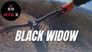
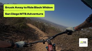
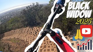
SDMBA worked with the city of San Diego to create a fun trail that is also more sustainable than the old scars that were there before. It has berm features with some with paver bricks added for erosion control. Also has some rock gardens and small rolly-jump features.

Trail is complete and ride-able. While not officially a downhill directional trail, be aware that most riders take the fire road up and descend on Black Widow. Ride with care in case anyone is coming uphill and avoid riding in wet conditions.

Access Info

Completed and open - June 2020.

Adaptive Bike Info
aMTB Blue Rating: Intermediate features and steeper terrain.

Suspension and clearance highly recommended. There is one rock garden and traversing sections that may require assistance.

Local Trail Association
Traditionally Indigenous Territory

Recent Activity on Trail

Past Week
  • 2 rides
  • 13 miles average
6 Months
  • 106 rides
  • 10 miles avg distance
All
  • 949 rides
  • Last: Jun 16, 2026
c1c2c3c4
January
February
March
April
May
June
July
August
September
October
November
December
update trails status or condition

Black Widow Trail Reports

Status:
on Mar 1, 2026
Ideal
Avg: 4.54 (31 votes)
Your vote: 0

view (7,909)
close
3D
Trail Conditions
  • Unknown
  • Snow Groomed
  • Snow Packed
  • Snow Covered
  • Snow Cover Partial
  • Freeze/thaw Cycle
  • Icy
  • Prevalent Mud
  • Wet
  • Variable
  • Ideal
  • Dry
  • Very Dry
Trail Flow (Ridden Direction)
Trailforks scans users ridelogs to determine the most popular direction each trail is ridden. A good flowing trail network will have most trails flowing in a single direction according to their intension.
The colour categories are based on what percentage of riders are riding a trail in its intended direction.
  • > 96%
  • > 90%
  • > 80%
  • > 70%
  • > 50%
  • < 50%
  • bi-directional trail
  • no data
Trail Last Ridden
Trailforks scans ridelogs to determine the last time a trail was ridden.
  • < 2 days
  • < 1 week
  • < 2 weeks
  • < 1 month
  • < 6 months
  • > 6 months
Trail Ridden Direction
The intended direction a trail should be ridden.
  • Downhill Only
  • Downhill Primary
  • Both Directions
  • Uphill Primary
  • Uphill Only
  • One Direction
Contribute Details
Colors indicate trail is missing specified detail.
  • Description
  • Photos
  • Description & Photos
  • Videos
Trail Popularity ?
Trailforks scans ridelogs to determine which trails are ridden the most in the last 9 months. Trails are compared with nearby trails in the same city region with a possible 25 colour shades. Think of this as a heatmap, more rides = more kinetic energy = warmer colors.
  • most popular
  • popular
  • less popular
  • not popular
ATV/ORV/OHV Filter
Max Vehicle Width
inches
US Cell Coverage
Legend
cell carrier legend

Radar Time
Activity Recordings
Trailforks uses anonymized public activity data. ?
Activity Recordings
Trailforks uses anonymized public activity data. ?
Personal Heatmap
Activity Types
all / none
Options
2
Date range month
Winter Trails
Warning A routing network for winter maps does not exist. Selecting trails using the winter trails layer has been disabled.
Missing Trails
Most Popular
Least Popular
Trails are colored based on popularity. The more popular a trail is, the more red. Less popular trails trend towards green.
Jump Magnitude Heatmap
Heatmap of where riders jump on trails. Zoom in to see individual jumps, click circles to view jump details.
BC Backroad Status

Service Road Atlas is a free to use, community-driven service for viewing and creating reports on the numerous back-country service roads around B.C. and Alberta.

map legend
Slope Aspect
Direction the slope faces
Flat N NE E SE S SW W NW
Trails Deemphasized
Trails are shown in grey.
disable
Only show trails with no bike usage.
Enable
Suggested Layers
Based on selected activity type

    Save the current map location and zoom level as your default home location whenever this page is loaded.

    Save
        Directions to black-widow trailhead (32.979790, -117.116490)

        Photos

        25 more »
        1,358 |
        Nov 23, 2019 @ 12:11pm
        Nov 23, 2019
        25 |
        May 30, 2026 @ 7:36pm
        May 30, 2026
        155 |
        Nov 17, 2023 @ 8:06am
        Nov 17, 2023
        275 |
        Nov 17, 2023 @ 8:06am
        Nov 17, 2023

        Videos

        23 more »
        youtuber Black Widow! A Black Mountain MTB Trail
        6:39 | 1074 | Mar 16, 2022 , San Diego
        Snuck Away to Ride Black Widow // San Diego...
        5:42 | 128 | Sep 4, 2025 , San Diego
        Black Widow
        16:35 | 193 | Mar 22, 2025 , San Diego
        Sunrise Ride to Beat the Heat at Black Mountain
        4:53 | 110 | Mar 12, 2025 , San Diego

        Routes with this trail

        5.0 15 miles 2,313 ft 19 Loop
        No, this isn't the . However, you might wonder if perhaps you've made a wrong turn and stumbled into one...
        4.5 9 miles 1,400 ft 29 Loop
        A black mountain route that includes fun trails like , downhill and trails. Extend the ride with and east...
        5.0 14 miles 1,996 ft 36 Loop
        MountainBikeBill's favorite long route at at Black Mountain. There is plenty of climbing for the distance...

        17 Reviews & Comments


        We hope you've been enjoying Trailforks!

        Create a FREE account to view trail comments and much more.

        • By The-dirt-farmerTF Pro & contributors
        • #62562 - 18,257 views

        Frequently Asked Questions About Black Widow

        Where is Black Widow located?
        Black Widow is located in Black Mountain, San Diego, California, United States. It is part of the Black Mountain trail network. The trailhead is located at coordinates 32.97979, -117.11649.
        How hard is Black Widow?
        Black Widow is rated as Black Diamond difficulty. The average grade is 10.3%.
        What is the elevation gain for Black Widow?
        The trail has 531 ft of elevation descent. The elevation ranges from 876 ft to 1,415 ft.
        Is Black Widow a point to point trail?
        Black Widow is not a point to point trail. The direction is Downhill Primary. The trail type is singletrack.

        Hit the Trail

        Open in App

        Get this trail on your phone instantly.
        open trail in app

        Download Trail

        Save to wishlist, Garmin & download.
        save the trail

        Find Related Routes

        Find routes and users activities that include this trail.
        find routes for this trail

        You must enter a description before submitting.