more stats
1.0 mile
Distance
-1,357 ft
Descent
00:12:07
Avg time
-1,359 ft
Altitude change
818 ft
Altitude min
2,177 ft
Altitude max
2,177 ft
Altitude start
817 ft
Altitude end
-24.8%
Grade
-78.3%
Grade max
-1.6%
Grade min
1 mile
Distance down
00:12:07
Avg time

Blackhawk Down Details

  • Activities
    • Mountain Bike
    • E-Bike
    • Hike
    • Trail Running
  • Riding Area
    Vedder Mountain
    Chilliwack, British Columbia
  • AKA
    Black Forest HAM
  • Difficulty Rating
  • Voted Difficulty
    Black Diamond (5 votes)
  • Local Popularity
    95 in Mountain Biking [+]
    • 95 in E-Biking
    • 50 in Trail Running
    • 5 in Hiking
  • Global Ranking
    #11285 in Mountain Biking [+]
    • #2636 in E-Biking
    • #91651 in Trail Running
    • #121412 in Hiking
  • Trail Type
    Singletrack
  • Bike Type
    DH, AM
  • Direction
    Downhill Only
    Popular Direction Shown
  • Physical Rating
    Hard
  • Dogs Allowed
    Yes
  • eBike Allowed
    Yes up to Class 1
  • TTFs on Trail
    Berm, Bridge, Drop, Jump, Gap Jump, Ladder Bridge
  • Year Opened
    2016
  • Land Owner
    RSTBC

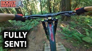
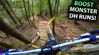
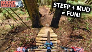
Loose, natural and steep. A few small drops, 2-3 feet, all of them have roll downs on though. Extremely loose in the wet. 5 minutes to get down at a fast pace. Lots of features/interesting bits of trail to session if you like that sort of thing,or just blast the whole thing Not for those who love their back brake a bit too much, it won't help you here! The whole trail can be done in about 4 pedal strokes.

Trail Supporters
  • past supporters

Local Trail Association
Traditionally Indigenous Territory

Recent Activity on Trail

Past Week
  • 1 rides
  • 12 miles average
6 Months
  • 44 rides
  • 10 miles avg distance
All
  • 384 rides
  • Last: Jun 14, 2026
c1c2c3c4
January
February
March
April
May
June
July
August
September
October
November
December
update trails status or condition

Blackhawk Down Trail Reports

statusdatedescription
Jun 11, 2026 @ 10:20am (America/Vancouver)
Jun 11, 2026
A little greasy throughout!
May 23, 2026 @ 4:22pm (America/Vancouver)
May 23, 2026
Big mess of trees down near the bottom, pretty difficult to even get around. Small-ish tree (6-7”) lots of branches
Apr 25, 2026 @ 10:42am (America/Vancouver)
Apr 25, 2026
Getting a little dry’ish but overall running good
Apr 9, 2026 @ 4:20pm (America/Vancouver)
Apr 9, 2026
Apr 6, 2026 @ 11:15am (America/Vancouver)
Apr 6, 2026
more »
Status:
on Jun 11, 2026
Variable
Avg: 4.66 (47 votes)
Your vote: 0

view (2,847)
close
3D
Trail Conditions
  • Unknown
  • Snow Groomed
  • Snow Packed
  • Snow Covered
  • Snow Cover Partial
  • Freeze/thaw Cycle
  • Icy
  • Prevalent Mud
  • Wet
  • Variable
  • Ideal
  • Dry
  • Very Dry
Trail Flow (Ridden Direction)
Trailforks scans users ridelogs to determine the most popular direction each trail is ridden. A good flowing trail network will have most trails flowing in a single direction according to their intension.
The colour categories are based on what percentage of riders are riding a trail in its intended direction.
  • > 96%
  • > 90%
  • > 80%
  • > 70%
  • > 50%
  • < 50%
  • bi-directional trail
  • no data
Trail Last Ridden
Trailforks scans ridelogs to determine the last time a trail was ridden.
  • < 2 days
  • < 1 week
  • < 2 weeks
  • < 1 month
  • < 6 months
  • > 6 months
Trail Ridden Direction
The intended direction a trail should be ridden.
  • Downhill Only
  • Downhill Primary
  • Both Directions
  • Uphill Primary
  • Uphill Only
  • One Direction
Contribute Details
Colors indicate trail is missing specified detail.
  • Description
  • Photos
  • Description & Photos
  • Videos
Trail Popularity ?
Trailforks scans ridelogs to determine which trails are ridden the most in the last 9 months. Trails are compared with nearby trails in the same city region with a possible 25 colour shades. Think of this as a heatmap, more rides = more kinetic energy = warmer colors.
  • most popular
  • popular
  • less popular
  • not popular
ATV/ORV/OHV Filter
Max Vehicle Width
inches
US Cell Coverage
Legend
cell carrier legend

Radar Time
Activity Recordings
Trailforks uses anonymized public activity data. ?
Activity Recordings
Trailforks uses anonymized public activity data. ?
Personal Heatmap
Activity Types
all / none
Options
2
Date range month
Winter Trails
Warning A routing network for winter maps does not exist. Selecting trails using the winter trails layer has been disabled.
Missing Trails
Most Popular
Least Popular
Trails are colored based on popularity. The more popular a trail is, the more red. Less popular trails trend towards green.
Jump Magnitude Heatmap
Heatmap of where riders jump on trails. Zoom in to see individual jumps, click circles to view jump details.
BC Backroad Status

Service Road Atlas is a free to use, community-driven service for viewing and creating reports on the numerous back-country service roads around B.C. and Alberta.

map legend
Slope Aspect
Direction the slope faces
Flat N NE E SE S SW W NW
Trails Deemphasized
Trails are shown in grey.
disable
Only show trails with no bike usage.
Enable
Suggested Layers
Based on selected activity type

    Save the current map location and zoom level as your default home location whenever this page is loaded.

    Save
        Directions to blackhawk-down trailhead (49.072540, -122.009430)

        Photos

        103 more »
        1,345 |
        May 8, 2017 @ 11:41am
        May 8, 2017
        2,207 |
        Jun 21, 2016 @ 6:05am
        Jun 21, 2016
        98 |
        Jul 4, 2023 @ 2:22pm
        Jul 4, 2023
        66 |
        Oct 27, 2022 @ 1:13pm
        Oct 27, 2022

        Videos

        21 more »
        youtuber I’VE NEVER GONE SO FAST On These AMAZING DH...
        27:52 | 1462 | Oct 9, 2019 , Chilliwack
        youtuber TESTING MY 300mm 'BOOSTMONSTER' ON FAST DH TRAILS!
        24:03 | 834 | May 12, 2022 , Chilliwack
        youtuber Seeing if I have Improved at the steeps! -...
        16:59 | 981 | Mar 11, 2020 , Chilliwack
        youtuber Summer's End
        3:57 | 945 | Jan 17, 2019 , Chilliwack

        Trail Lists

        Routes with this trail

        11 miles 3,504 ft 14
        Fraser Valley Vedder Shuttle Epic Relive Your Rides For other ride suggestions for this and other areas....
        17 miles 5,416 ft 24 Point to Point Race
        SHORT COURSE = Stages 1,2,3 More information can be found in the 'Event Guide + Race Book' on our website
        2.0 16 miles 4,100 ft 32
        Bro Trip Vedder Lap! Can cut short if needed.

        7 Reviews & Comments


        We hope you've been enjoying Trailforks!

        Create a FREE account to view trail comments and much more.

        • By eklieverTF Pro VMTA & contributors
        • #55499 - 16,775 views

        Frequently Asked Questions About Blackhawk Down

        Where is Blackhawk Down located?
        Blackhawk Down is located in Vedder Mountain, Chilliwack, British Columbia, Canada. It is part of the Vedder Mountain trail network. The trailhead is located at coordinates 49.07254, -122.00943.
        How hard is Blackhawk Down?
        Blackhawk Down is rated as Black Diamond difficulty. The physical rating is Hard. The average grade is 24.8%.
        What is the elevation gain for Blackhawk Down?
        The trail has 414 m of elevation descent. The elevation ranges from 249 m to 664 m.
        Is Blackhawk Down a point to point trail?
        Yes, Blackhawk Down is a point to point trail. The direction is Downhill Only. The trail type is singletrack.

        Hit the Trail

        Open in App

        Get this trail on your phone instantly.
        open trail in app

        Download Trail

        Save to wishlist, Garmin & download.
        save the trail

        Find Related Routes

        Find routes and users activities that include this trail.
        find routes for this trail

        You must enter a description before submitting.