more stats
1.2 miles
Distance
37 ft
Climb
-527 ft
Descent
00:05:32
Avg time
-492 ft
Altitude change
833 ft
Altitude min
1,325 ft
Altitude max
1,325 ft
Altitude start
833 ft
Altitude end
-7.8%
Grade
-30.3%
Grade max
14.4%
Grade min
377 ft
Distance climb
1 mile
Distance down
466 ft
Distance flat
00:05:32
Avg time

Blind Snake Details

  • Activities
    • Mountain Bike
    • E-Bike
  • Riding Area
  • Difficulty Rating
  • Local Popularity
    80 in Mountain Biking
  • Global Ranking
    #1654 in Mountain Biking
  • Trail Type
    Singletrack
  • Bike Type
    AM
  • Direction
    Downhill Only[+]
    Popular Direction Shown
    • Downhill Only for E-Biking
  • Physical Rating
    Moderate
  • Trail Visibility
    Always easy to follow
  • eBike Allowed
    Yes up to Class 1
  • TTFs on Trail
    Berm, Jump, Rock Garden
  • Year Opened
    2022

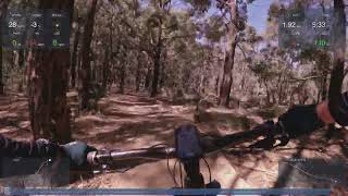
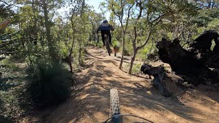
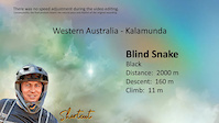
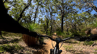
Fast "difficult" (black) descent from summit to Gungin base. Rocky features and drops followed by large step down and table tops. Grade mellows .. rock gardens and rollers.

Local Trail Association
Traditionally Indigenous Territory

Recent Activity on Trail

Past Week
  • 3 rides
  • 12 miles average
6 Months
  • 37 rides
  • 12 miles avg distance
All
  • 173 rides
  • Last: Jun 27, 2026
c1c2c3c4
January
February
March
April
May
June
July
August
September
October
November
December
update trails status or condition

Blind Snake Trail Reports

statusdatedescription
Jun 21, 2026 @ 8:46am (Australia/Perth)
Jun 20, 2026
Dec 19, 2025 @ 2:09am (Australia/Perth)
Dec 18, 2025
Large trees down across trail, blocking trail. Section just after the last table top jump and the fast pumping rollers.
Jun 28, 2025 @ 11:30pm
Jun 28, 2025
Minor erosion (trail braiding, small ruts developing, brake bumps)
Jun 14, 2025 @ 3:12am
Jun 14, 2025
Minor erosion (trail braiding, small ruts developing, brake bumps)before powerlines
May 31, 2025 @ 10:08pm
May 31, 2025
Minor erosion before powerlines(trail braiding, small ruts developing, brake bumps)
more »
Status:
on Jun 21, 2026
Ideal
Avg: 4.39 (4 votes)
Your vote: 0

view (2,073)
close
3D
Trail Conditions
  • Unknown
  • Snow Groomed
  • Snow Packed
  • Snow Covered
  • Snow Cover Partial
  • Freeze/thaw Cycle
  • Icy
  • Prevalent Mud
  • Wet
  • Variable
  • Ideal
  • Dry
  • Very Dry
Trail Flow (Ridden Direction)
Trailforks scans users ridelogs to determine the most popular direction each trail is ridden. A good flowing trail network will have most trails flowing in a single direction according to their intension.
The colour categories are based on what percentage of riders are riding a trail in its intended direction.
  • > 96%
  • > 90%
  • > 80%
  • > 70%
  • > 50%
  • < 50%
  • bi-directional trail
  • no data
Trail Last Ridden
Trailforks scans ridelogs to determine the last time a trail was ridden.
  • < 2 days
  • < 1 week
  • < 2 weeks
  • < 1 month
  • < 6 months
  • > 6 months
Trail Ridden Direction
The intended direction a trail should be ridden.
  • Downhill Only
  • Downhill Primary
  • Both Directions
  • Uphill Primary
  • Uphill Only
  • One Direction
Contribute Details
Colors indicate trail is missing specified detail.
  • Description
  • Photos
  • Description & Photos
  • Videos
Trail Popularity ?
Trailforks scans ridelogs to determine which trails are ridden the most in the last 9 months. Trails are compared with nearby trails in the same city region with a possible 25 colour shades. Think of this as a heatmap, more rides = more kinetic energy = warmer colors.
  • most popular
  • popular
  • less popular
  • not popular
ATV/ORV/OHV Filter
Max Vehicle Width
inches
US Cell Coverage
Legend
cell carrier legend

Radar Time
Activity Recordings
Trailforks uses anonymized public activity data. ?
Activity Recordings
Trailforks uses anonymized public activity data. ?
Personal Heatmap
Activity Types
all / none
Options
2
Date range month
Winter Trails
Warning A routing network for winter maps does not exist. Selecting trails using the winter trails layer has been disabled.
Missing Trails
Most Popular
Least Popular
Trails are colored based on popularity. The more popular a trail is, the more red. Less popular trails trend towards green.
Jump Magnitude Heatmap
Heatmap of where riders jump on trails. Zoom in to see individual jumps, click circles to view jump details.
BC Backroad Status

Service Road Atlas is a free to use, community-driven service for viewing and creating reports on the numerous back-country service roads around B.C. and Alberta.

map legend
Slope Aspect
Direction the slope faces
Flat N NE E SE S SW W NW
Trails Deemphasized
Trails are shown in grey.
disable
Only show trails with no bike usage.
Enable
Suggested Layers
Based on selected activity type

    Save the current map location and zoom level as your default home location whenever this page is loaded.

    Save
        Directions to blind-snake trailhead (-31.988840, 116.130620)

        Photos

        No photos have been added for Blind Snake yet, add a photo.

        Videos

        4 more »
        Blind Snake ♦︎ 21 March 2026
        5:53 | 91 | Mar 24, 2026 , Kalamunda
        Tight & fast Blind Snake @ Kalamunda full...
        4:11 | 411 | Jun 24, 2024 , Kalamunda
        MTB Kalamunda Blind Snake
        4:56 | 60 | Dec 25, 2024 , Kalamunda
        Blind snake & rider
        0:20 | 129 | Nov 28, 2023 , Kalamunda

        Reviews / Comments

        No reviews yet, be the first to write a review or ask a question.
        Use trail reports to comment on trail conditions.


        We hope you've been enjoying Trailforks!

        Create a FREE account to view trail comments and much more.

        • By sweatytechieTF Pro MTBWA & contributors
        • #569487 - 1,759 views

        Frequently Asked Questions About Blind Snake

        Where is Blind Snake located?
        Blind Snake is located in Kalamunda Trail Network, Kalamunda, Australia. It is part of the Kalamunda Trail Network trail network. The trailhead is located at coordinates -31.98884, 116.13062.
        How hard is Blind Snake?
        Blind Snake is rated as Black Diamond difficulty. The physical rating is Moderate. The average grade is 7.8%.
        What is the elevation gain for Blind Snake?
        Blind Snake has 11 m of elevation gain. The trail has 161 m of elevation descent. The elevation ranges from 254 m to 404 m.
        Is Blind Snake a point to point trail?
        Yes, Blind Snake is a point to point trail. The direction is Downhill Only. The trail type is singletrack.

        Hit the Trail

        Open in App

        Get this trail on your phone instantly.
        open trail in app

        Download Trail

        Save to wishlist, Garmin & download.
        save the trail

        Find Related Routes

        Find routes and users activities that include this trail.
        find routes for this trail

        You must enter a description before submitting.