more stats
3,278 ft
Distance
20 ft
Climb
-386 ft
Descent
00:04:53
Avg time
-367 ft
Altitude change
2,559 ft
Altitude min
2,926 ft
Altitude max
2,926 ft
Altitude start
2,559 ft
Altitude end
-11.2%
Grade
-44.9%
Grade max
34.4%
Grade min
256 ft
Distance climb
2,671 ft
Distance down
351 ft
Distance flat
00:04:53
Avg time

B-Line - Lower Details

  • Activities
    • Mountain Bike
    • Adaptive Bike
  • Riding Area
    Whistler Mountain Bike Park
    Whistler, British Columbia
  • Difficulty Rating
  • Voted Difficulty
    Blue (1 vote)
  • Local Popularity
    75 in Mountain Biking
  • Global Ranking
    #691 in Mountain Biking
  • Trail Type
    Machine Groomed
  • Bike Type
    DH, AM, Adaptive MTB
  • Direction
    Downhill Only
    Popular Direction Shown
  • Trail Visibility
    Always easy to follow
  • Family Friendly
    Yes
  • TTFs on Trail
    Berm, Jump
  • Land Owner

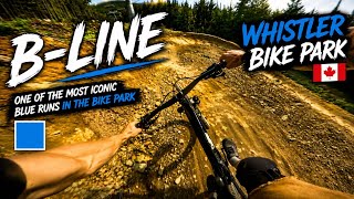
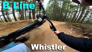
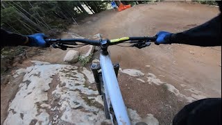
B-Line is an intermediate groomed jump trail that will prepare you for some of the more advanced trails at Whistler. You'll find some great berms to practice your cornering, jumps, and a few rock sections. The trail provides access to several blue tech trails as well. There are no gaps, only tables so beginners can get the hang of things.

Bike Park

Recent Activity on Trail

Past Week
  • 44 rides
  • 19 miles average
6 Months
  • 266 rides
  • 21 miles avg distance
All
  • 3,644 rides
  • Last: Jun 27, 2026
c1c2c3c4
January
February
March
April
May
June
July
August
September
October
November
December
Status:
on Jun 21, 2026
Very Dry
Avg: 4.01 (110 votes)
Your vote: 0

view (21,432)
close
3D
Trail Conditions
  • Unknown
  • Snow Groomed
  • Snow Packed
  • Snow Covered
  • Snow Cover Partial
  • Freeze/thaw Cycle
  • Icy
  • Prevalent Mud
  • Wet
  • Variable
  • Ideal
  • Dry
  • Very Dry
Trail Flow (Ridden Direction)
Trailforks scans users ridelogs to determine the most popular direction each trail is ridden. A good flowing trail network will have most trails flowing in a single direction according to their intension.
The colour categories are based on what percentage of riders are riding a trail in its intended direction.
  • > 96%
  • > 90%
  • > 80%
  • > 70%
  • > 50%
  • < 50%
  • bi-directional trail
  • no data
Trail Last Ridden
Trailforks scans ridelogs to determine the last time a trail was ridden.
  • < 2 days
  • < 1 week
  • < 2 weeks
  • < 1 month
  • < 6 months
  • > 6 months
Trail Ridden Direction
The intended direction a trail should be ridden.
  • Downhill Only
  • Downhill Primary
  • Both Directions
  • Uphill Primary
  • Uphill Only
  • One Direction
Contribute Details
Colors indicate trail is missing specified detail.
  • Description
  • Photos
  • Description & Photos
  • Videos
Trail Popularity ?
Trailforks scans ridelogs to determine which trails are ridden the most in the last 9 months. Trails are compared with nearby trails in the same city region with a possible 25 colour shades. Think of this as a heatmap, more rides = more kinetic energy = warmer colors.
  • most popular
  • popular
  • less popular
  • not popular
ATV/ORV/OHV Filter
Max Vehicle Width
inches
US Cell Coverage
Legend
cell carrier legend

Radar Time
Activity Recordings
Trailforks uses anonymized public activity data. ?
Activity Recordings
Trailforks uses anonymized public activity data. ?
Personal Heatmap
Activity Types
all / none
Options
2
Date range month
Winter Trails
Warning A routing network for winter maps does not exist. Selecting trails using the winter trails layer has been disabled.
Missing Trails
Most Popular
Least Popular
Trails are colored based on popularity. The more popular a trail is, the more red. Less popular trails trend towards green.
Jump Magnitude Heatmap
Heatmap of where riders jump on trails. Zoom in to see individual jumps, click circles to view jump details.
BC Backroad Status

Service Road Atlas is a free to use, community-driven service for viewing and creating reports on the numerous back-country service roads around B.C. and Alberta.

map legend
Slope Aspect
Direction the slope faces
Flat N NE E SE S SW W NW
Trails Deemphasized
Trails are shown in grey.
disable
Only show trails with no bike usage.
Enable
Suggested Layers
Based on selected activity type

    Save the current map location and zoom level as your default home location whenever this page is loaded.

    Save
        Directions to bline-lower trailhead (50.104300, -122.954590)

        Photos

        53 more »
        194 |
        Jul 22, 2017 @ 1:23pm
        Jul 22, 2017
        444 |
        Aug 11, 2015 @ 7:52am
        Aug 11, 2015
        132 |
        Mar 27, 2023 @ 4:57pm
        Mar 27, 2023
        111 |
        Aug 29, 2022 @ 3:47am
        Aug 29, 2022

        Videos

        19 more »
        youtuber B-LINE | Blue trail | WHISTLER Bike Park
        3:58 | 19 | Jun 18, 2026 , Whistler
        B Line - Whistler
        5:16 | 49 | Nov 4, 2025 , Whistler
        B-LINE | Blue trail | Whistler Bikepark
        3:11 | 201 | Nov 27, 2023 , Whistler
        Whistler Bike Park 2023 - B-Line [4K] POV Trail
        6:37 | 295 | Jun 24, 2023 , Whistler

        Routes with this trail

        5 miles 1,249 ft 26
        Bike park Ride!! Start - Yellow gate at access road. Access Road UP Singing Pass UP to Crank it up...
        4 miles 807 ft 22 Race
        Start at bottom of Whistler Bike Park Up main road to connect to Easy Does It. Turn to B-Line up all the...
        2 miles 10 ft 12 Race
        Kidsworx @ Crankworx Stage 3 of 3 - Enduro race. August 10th 2018

        Reviews / Comments

        No reviews yet, be the first to write a review or ask a question.
        Use trail reports to comment on trail conditions.


        We hope you've been enjoying Trailforks!

        Create a FREE account to view trail comments and much more.

        • By Tekmisfit & contributors
        • #2473 - 11,493 views

        Frequently Asked Questions About B-Line - Lower

        Where is B-Line - Lower located?
        B-Line - Lower is located in Whistler Mountain Bike Park, Whistler, British Columbia, Canada. It is part of the Whistler Mountain Bike Park trail network. The trailhead is located at coordinates 50.1043, -122.95459.
        How hard is B-Line - Lower?
        B-Line - Lower is rated as Blue difficulty. The average grade is 11.2%.
        What is the elevation gain for B-Line - Lower?
        B-Line - Lower has 20 ft of elevation gain. The trail has 386 ft of elevation descent. The elevation ranges from 2,559 ft to 2,926 ft.
        Is B-Line - Lower a point to point trail?
        Yes, B-Line - Lower is a point to point trail. The direction is Downhill Only. The trail type is machine groomed.

        Hit the Trail

        Open in App

        Get this trail on your phone instantly.
        open trail in app

        Download Trail

        Save to wishlist, Garmin & download.
        save the trail

        Find Related Routes

        Find routes and users activities that include this trail.
        find routes for this trail

        You must enter a description before submitting.