more stats
7.5 miles
Distance
550 ft
Climb
-538 ft
Descent
00:48:36
Avg time
11 ft
Altitude change
687 ft
Altitude min
794 ft
Altitude max
782 ft
Altitude start
794 ft
Altitude end
-21.6%
Grade max
32.4%
Grade min
2 miles
Distance climb
2 miles
Distance down
4 miles
Distance flat
00:48:36
Avg time

Bloomer Trail Details

  • Activities
    • Mountain Bike
    • Hike
    • Trail Running
  • Riding Area
    Bloomer Park
    Rochester, Michigan
  • Difficulty Rating
  • Voted Difficulty
    Black Diamond (2 votes)
  • Local Popularity
    75 in Mountain Biking [+]
    • 5 in Trail Running
    • 60 in Hiking
  • Global Ranking
    #7291 in Mountain Biking [+]
    • #127434 in Trail Running
    • #66682 in Hiking
  • Trail Type
    Singletrack
  • Bike Type
    AM, XC
  • Direction
    Downhill Primary
    Popular Direction Shown
  • Dogs Allowed
    Yes
  • eBike Allowed

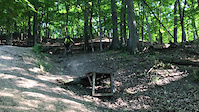
This is a great trail for experienced riders in southeast Michigan. It offers some big drops and decent descents. If you come from out of state/somewhere that has harder trails this might be a easier ride. Locals might find this trail hard though, mainly because of the lack of hard trails in southeast Michigan. Locals will benefit from experience while riding this trail.

Local Trail Association

Recent Activity on Trail

Past Week
  • 0 rides
  •  
6 Months
  • 14 rides
  • 11 miles avg distance
All
  • 192 rides
  • Last: Jun 13, 2026
c1c2c3c4
January
February
March
April
May
June
July
August
September
October
November
December
Status:
on Apr 12, 2026
Variable
Avg: 4.19 (4 votes)
Your vote: 0

view (1,798)
close
3D
Trail Conditions
  • Unknown
  • Snow Groomed
  • Snow Packed
  • Snow Covered
  • Snow Cover Partial
  • Freeze/thaw Cycle
  • Icy
  • Prevalent Mud
  • Wet
  • Variable
  • Ideal
  • Dry
  • Very Dry
Trail Flow (Ridden Direction)
Trailforks scans users ridelogs to determine the most popular direction each trail is ridden. A good flowing trail network will have most trails flowing in a single direction according to their intension.
The colour categories are based on what percentage of riders are riding a trail in its intended direction.
  • > 96%
  • > 90%
  • > 80%
  • > 70%
  • > 50%
  • < 50%
  • bi-directional trail
  • no data
Trail Last Ridden
Trailforks scans ridelogs to determine the last time a trail was ridden.
  • < 2 days
  • < 1 week
  • < 2 weeks
  • < 1 month
  • < 6 months
  • > 6 months
Trail Ridden Direction
The intended direction a trail should be ridden.
  • Downhill Only
  • Downhill Primary
  • Both Directions
  • Uphill Primary
  • Uphill Only
  • One Direction
Contribute Details
Colors indicate trail is missing specified detail.
  • Description
  • Photos
  • Description & Photos
  • Videos
Trail Popularity ?
Trailforks scans ridelogs to determine which trails are ridden the most in the last 9 months. Trails are compared with nearby trails in the same city region with a possible 25 colour shades. Think of this as a heatmap, more rides = more kinetic energy = warmer colors.
  • most popular
  • popular
  • less popular
  • not popular
ATV/ORV/OHV Filter
Max Vehicle Width
inches
US Cell Coverage
Legend
cell carrier legend

Radar Time
Activity Recordings
Trailforks uses anonymized public activity data. ?
Activity Recordings
Trailforks uses anonymized public activity data. ?
Personal Heatmap
Activity Types
all / none
Options
2
Date range month
Winter Trails
Warning A routing network for winter maps does not exist. Selecting trails using the winter trails layer has been disabled.
Missing Trails
Most Popular
Least Popular
Trails are colored based on popularity. The more popular a trail is, the more red. Less popular trails trend towards green.
Jump Magnitude Heatmap
Heatmap of where riders jump on trails. Zoom in to see individual jumps, click circles to view jump details.
BC Backroad Status

Service Road Atlas is a free to use, community-driven service for viewing and creating reports on the numerous back-country service roads around B.C. and Alberta.

map legend
Slope Aspect
Direction the slope faces
Flat N NE E SE S SW W NW
Trails Deemphasized
Trails are shown in grey.
disable
Only show trails with no bike usage.
Enable
Suggested Layers
Based on selected activity type

    Save the current map location and zoom level as your default home location whenever this page is loaded.

    Save
        Directions to bloomer-trail trailhead (42.679060, -83.108830)

        Photos

        21 more »
        27 |
        Apr 27, 2026 @ 1:41pm
        Apr 27, 2026
        30 |
        Apr 27, 2026 @ 1:41pm
        Apr 27, 2026
        28 |
        Apr 27, 2026 @ 1:41pm
        Apr 27, 2026
        36 |
        Apr 27, 2026 @ 1:41pm
        Apr 27, 2026

        Videos

        3 more »
        youtuber Searching for Gnar at Bloomer Park •...
        10:51 | 1406 | Oct 29, 2018 , Rochester
        submission to friday fails
        0:07 | 372 | Dec 7, 2020 , Rochester
        Friday Fails submission
        0:11 | 484 | Nov 10, 2019 , Rochester

        Routes with this trail

        7 miles 489 ft 1 Loop
        This is one of my favorite local XC trails to ride. It consist of 7 miles of single-track with a lot of...

        8 Reviews & Comments


        We hope you've been enjoying Trailforks!

        Create a FREE account to view trail comments and much more.

        Frequently Asked Questions About Bloomer Trail

        Where is Bloomer Trail located?
        Bloomer Trail is located in Bloomer Park, Rochester, Michigan, United States. It is part of the Bloomer Park trail network. The trailhead is located at coordinates 42.67906, -83.10883.
        How hard is Bloomer Trail?
        Bloomer Trail is rated as Black Diamond difficulty.
        What is the elevation gain for Bloomer Trail?
        Bloomer Trail has 550 ft of elevation gain. The trail has 538 ft of elevation descent. The elevation ranges from 687 ft to 794 ft.
        Is Bloomer Trail a point to point trail?
        Bloomer Trail is not a point to point trail. The direction is Downhill Primary. The trail type is singletrack.

        Hit the Trail

        Open in App

        Get this trail on your phone instantly.
        open trail in app

        Download Trail

        Save to wishlist, Garmin & download.
        save the trail

        Find Related Routes

        Find routes and users activities that include this trail.
        find routes for this trail

        You must enter a description before submitting.