more stats
1,437 ft
Distance
-144 ft
Descent
00:01:23
Avg time
-144 ft
Altitude change
7,460 ft
Altitude min
7,604 ft
Altitude max
7,604 ft
Altitude start
7,461 ft
Altitude end
-10%
Grade
-25.5%
Grade max
-1.4%
Grade min
1,385 ft
Distance down
49 ft
Distance flat
00:01:23
Avg time

BLT Jump Details

  • Activities
    • Mountain Bike
    • E-Bike
    • Hike
    • Trail Running
  • Riding Area
    West Avon Preserve
    Avon, Colorado
  • Difficulty Rating
  • Voted Difficulty
    Blue (2 votes)
  • Local Popularity
    100 in Mountain Biking [+]
    • 80 in E-Biking
    • 50 in Trail Running
    • 55 in Hiking
  • Global Ranking
    #40225 in Mountain Biking [+]
    • #115286 in Trail Running
    • #300455 in Hiking
  • Trail Type
    Singletrack
  • Bike Type
    DH, AM, DJ
  • Physical Rating
    Moderate
  • Trail Visibility
    Always easy to follow
  • eBike Allowed
    Yes up to Class 1
  • TTFs on Trail
    Berm, Jump

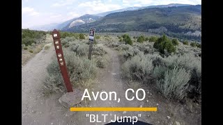
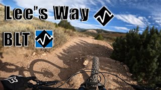
BLT Jump is a shorter flow trail that starts with a series of bermed corners before a couple of tabletop jumps and then more berms and tabletops. It basically is the proper finish to Lee's Way Down with smaller features. It can be sessioned by riding Avon Singletree Connector back to the start. A great trail for building confidence and skill and a great finish to Lee's Way Down.

All of the trails in the West Avon Preserve with the exception of Our Backyard, PB&J, & Beaver Creek Point are seasonally closed to protect Elk/Deer habitat from December 15th - April 15th each year reopening on April 16th.

Trail Supporters

  • USFS
    Land Manager
Local Trail Association
Traditionally Indigenous Territory

Recent Activity on Trail

Past Week
  • 6 rides
  • 9 miles average
6 Months
  • 25 rides
  • 10 miles avg distance
All
  • 448 rides
  • Last: Jun 6, 2026
c1c2c3c4
January
February
March
April
May
June
July
August
September
October
November
December
update trails status or condition

BLT Jump Trail Reports

statusdatedescription
May 19, 2026 @ 11:23am (America/Denver)
May 19, 2026
reporter
Apr 16, 2026 @ 12:03am (America/Los_Angeles)
Apr 16, 2026
Dec 15, 2025 @ 1:00am (America/Denver)
Dec 15, 2025
reporter This trail is closed seasonally to all users from 12/15 thru 4/15 to protect deer and elk habitat.
Aug 3, 2025 @ 4:58pm
Aug 3, 2025
Aug 3, 2025 @ 4:58pm
Aug 3, 2025
more »
Status:
on May 19, 2026
Dry
Avg: 4.08 (5 votes)
Your vote: 0

view (6,574)
close
3D
Trail Conditions
  • Unknown
  • Snow Groomed
  • Snow Packed
  • Snow Covered
  • Snow Cover Partial
  • Freeze/thaw Cycle
  • Icy
  • Prevalent Mud
  • Wet
  • Variable
  • Ideal
  • Dry
  • Very Dry
Trail Flow (Ridden Direction)
Trailforks scans users ridelogs to determine the most popular direction each trail is ridden. A good flowing trail network will have most trails flowing in a single direction according to their intension.
The colour categories are based on what percentage of riders are riding a trail in its intended direction.
  • > 96%
  • > 90%
  • > 80%
  • > 70%
  • > 50%
  • < 50%
  • bi-directional trail
  • no data
Trail Last Ridden
Trailforks scans ridelogs to determine the last time a trail was ridden.
  • < 2 days
  • < 1 week
  • < 2 weeks
  • < 1 month
  • < 6 months
  • > 6 months
Trail Ridden Direction
The intended direction a trail should be ridden.
  • Downhill Only
  • Downhill Primary
  • Both Directions
  • Uphill Primary
  • Uphill Only
  • One Direction
Contribute Details
Colors indicate trail is missing specified detail.
  • Description
  • Photos
  • Description & Photos
  • Videos
Trail Popularity ?
Trailforks scans ridelogs to determine which trails are ridden the most in the last 9 months. Trails are compared with nearby trails in the same city region with a possible 25 colour shades. Think of this as a heatmap, more rides = more kinetic energy = warmer colors.
  • most popular
  • popular
  • less popular
  • not popular
ATV/ORV/OHV Filter
Max Vehicle Width
inches
US Cell Coverage
Legend
cell carrier legend

Radar Time
Activity Recordings
Trailforks uses anonymized public activity data. ?
Activity Recordings
Trailforks uses anonymized public activity data. ?
Personal Heatmap
Activity Types
all / none
Options
2
Date range month
Winter Trails
Warning A routing network for winter maps does not exist. Selecting trails using the winter trails layer has been disabled.
Missing Trails
Most Popular
Least Popular
Trails are colored based on popularity. The more popular a trail is, the more red. Less popular trails trend towards green.
Jump Magnitude Heatmap
Heatmap of where riders jump on trails. Zoom in to see individual jumps, click circles to view jump details.
BC Backroad Status

Service Road Atlas is a free to use, community-driven service for viewing and creating reports on the numerous back-country service roads around B.C. and Alberta.

map legend
Slope Aspect
Direction the slope faces
Flat N NE E SE S SW W NW
Trails Deemphasized
Trails are shown in grey.
disable
Only show trails with no bike usage.
Enable
Suggested Layers
Based on selected activity type

    Save the current map location and zoom level as your default home location whenever this page is loaded.

    Save
        Directions to blt-jump trailhead (39.641200, -106.545200)

        Photos

        5 more »
        24 |
        Aug 4, 2025 @ 5:29pm
        Aug 4, 2025
        21 |
        Aug 4, 2025 @ 5:29pm
        Aug 4, 2025
        29 |
        Aug 4, 2025 @ 5:29pm
        Aug 4, 2025
        27 |
        Aug 4, 2025 @ 5:29pm
        Aug 4, 2025

        Videos

        2 more »
        West Avon Preserve MTB trail - 'BLT Jump'
        0:18 | 43 | Aug 4, 2025 , Avon
        2 Flowy Trails in Avon Colorado: Lee’s Way...
        5:09 | 166 | Jun 2, 2024 , Avon

        Routes with this trail

        5 miles 929 ft 9 Loop
        Start off at the small parking lot at the end of the road. Either park or ride from Avon town center....

        Reviews / Comments

        No reviews yet, be the first to write a review or ask a question.
        Use trail reports to comment on trail conditions.


        We hope you've been enjoying Trailforks!

        Create a FREE account to view trail comments and much more.

        • By toddTF Pro Trailforks & contributors
        • #39585 - 1,912 views

        Frequently Asked Questions About BLT Jump

        Where is BLT Jump located?
        BLT Jump is located in West Avon Preserve, Avon, Colorado, United States. It is part of the West Avon Preserve trail network. The trailhead is located at coordinates 39.6412, -106.5452.
        How hard is BLT Jump?
        BLT Jump is rated as Blue difficulty. The physical rating is Moderate. The average grade is 10%.
        What is the elevation gain for BLT Jump?
        The trail has 144 ft of elevation descent. The elevation ranges from 7,460 ft to 7,604 ft.
        How long is BLT Jump?
        BLT Jump is 1,437 ft long. The trail type is singletrack.

        Hit the Trail

        Open in App

        Get this trail on your phone instantly.
        open trail in app

        Download Trail

        Save to wishlist, Garmin & download.
        save the trail

        Find Related Routes

        Find routes and users activities that include this trail.
        find routes for this trail

        You must enter a description before submitting.