more stats
4,905 ft
Distance
8 ft
Climb
-3 ft
Descent
00:12:17
Avg time
6 ft
Altitude change
1,202 ft
Altitude min
1,209 ft
Altitude max
1,203 ft
Altitude start
1,211 ft
Altitude end
0.1%
Grade
-1.8%
Grade max
3.8%
Grade min
518 ft
Distance climb
174 ft
Distance down
4,144 ft
Distance flat
00:12:17
Avg time

Blue Highway to Lollipop Details

  • Activities
    • Mountain Bike
    • E-Bike
    • Gravel Bike
    • Winter Fat Bike
    • Hike
    • Trail Running
    • Snowshoe
  • Riding Area
    McGillivray Falls / Caddy Lake
    West Hawk Lake, Manitoba
  • Difficulty Rating
  • Local Popularity
    95 in Mountain Biking [+]
    • 85 in E-Biking
    • 65 in Trail Running
    • 80 in Hiking
    • 5 in Snowshoeing
  • Global Ranking
    #40367 in Mountain Biking [+]
    • #40097 in E-Biking
    • #98540 in Trail Running
    • #123107 in Hiking
  • Blaze Color
  • Trail Type
    Singletrack
  • Snow Grooming
    Backcountry
  • Bike Type
    AM, XC, Fat, Gravel
  • Direction
    Both Directions[+]
    • Both Directions for Gravel Biking
  • Climb Difficulty
    Blue
  • Physical Rating
    Moderate
  • Trail Visibility
    Always easy to follow
  • Family Friendly
    Yes
  • Dogs Allowed
    Yes
  • eBike Allowed
    Yes up to Class 1
  • TTFs on Trail
    Bridge, Drop, Jump, Ladder Bridge, Rock Face, Rock Garden

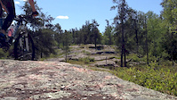
Blue Highway is an out-and-back along the same trail with a "lollipop" loop at the end to turn you around. Most of the trail is on open rock face with some dirt single track connectors between open rock area. You have to climb a few minutes through single track dirt trail to get to the rock. Access to the main Blue Highway loop is via Centennial Trail, also open rock face. Centennial is mixed used, and Blue Highway was designed for mountain biking, but is also open to hikers. You'll find mostly mountain bikers on Blue Highway.

Riders comment mostly on how well the trail flows, with lot's of options to drop or roll 1 - 3 foot drops. The connector from Caddy Lake is worth the extra 5-10 minutes as you're treated to a wood wall ride, and lots of flowing open rock face on your way to the McGillivray Falls parking lot, which feeds to the main access point to the Blue Highway trail. The trail is well signed.

Throughout the trail system there are a few challenging "A line" drops, each of which have ride arounds. This is definitely one of the most fun trails in the area

Access Info

There are two optional trail head starting places. One is at McGillivray Falls, the other, just a few minutes by bike/ car away, is Caddy Lake Resort camp ground. Both have ample parking. The trail head is about 160 km East from the city of Winnipeg, taking either Highway #15 and #44 or highway #1 and #44 (West Hawk turn off), and about 11km west of West Hawk Lake MB on Hwy 44. If you're coming from Falcon Trails Resort it's about 35km with two options, Hwy #1 and #44, or Hwy 301 (a rural Hwy).

The trail head at Caddy Lake is on the south side of Hwy 44, at the junction of Hwy 44 and Fireroad C 2 (which is the road into the camp ground - resort. There are signs at both trail heads designating Blue Highway, and directional signs to guide you through the entire trail.

Disclaimer

Please wear helmet. Riders assume all risks.

Local Trail Association

Recent Activity on Trail

Past Week
  • 1 rides
  • 6 miles average
6 Months
  • 12 rides
  • 11 miles avg distance
All
  • 319 rides
  • Last: Jun 18, 2026
c1c2c3c4
January
February
March
April
May
June
July
August
September
October
November
December
Status:
on May 16, 2026
Snow Groomed
Avg: 4.44 (5 votes)
Your vote: 0

view (3,267)
close
3D
Trail Conditions
  • Unknown
  • Snow Groomed
  • Snow Packed
  • Snow Covered
  • Snow Cover Partial
  • Freeze/thaw Cycle
  • Icy
  • Prevalent Mud
  • Wet
  • Variable
  • Ideal
  • Dry
  • Very Dry
Trail Flow (Ridden Direction)
Trailforks scans users ridelogs to determine the most popular direction each trail is ridden. A good flowing trail network will have most trails flowing in a single direction according to their intension.
The colour categories are based on what percentage of riders are riding a trail in its intended direction.
  • > 96%
  • > 90%
  • > 80%
  • > 70%
  • > 50%
  • < 50%
  • bi-directional trail
  • no data
Trail Last Ridden
Trailforks scans ridelogs to determine the last time a trail was ridden.
  • < 2 days
  • < 1 week
  • < 2 weeks
  • < 1 month
  • < 6 months
  • > 6 months
Trail Ridden Direction
The intended direction a trail should be ridden.
  • Downhill Only
  • Downhill Primary
  • Both Directions
  • Uphill Primary
  • Uphill Only
  • One Direction
Contribute Details
Colors indicate trail is missing specified detail.
  • Description
  • Photos
  • Description & Photos
  • Videos
Trail Popularity ?
Trailforks scans ridelogs to determine which trails are ridden the most in the last 9 months. Trails are compared with nearby trails in the same city region with a possible 25 colour shades. Think of this as a heatmap, more rides = more kinetic energy = warmer colors.
  • most popular
  • popular
  • less popular
  • not popular
ATV/ORV/OHV Filter
Max Vehicle Width
inches
US Cell Coverage
Legend
cell carrier legend

Radar Time
Activity Recordings
Trailforks uses anonymized public activity data. ?
Activity Recordings
Trailforks uses anonymized public activity data. ?
Personal Heatmap
Activity Types
all / none
Options
2
Date range month
Winter Trails
Warning A routing network for winter maps does not exist. Selecting trails using the winter trails layer has been disabled.
Missing Trails
Most Popular
Least Popular
Trails are colored based on popularity. The more popular a trail is, the more red. Less popular trails trend towards green.
Jump Magnitude Heatmap
Heatmap of where riders jump on trails. Zoom in to see individual jumps, click circles to view jump details.
BC Backroad Status

Service Road Atlas is a free to use, community-driven service for viewing and creating reports on the numerous back-country service roads around B.C. and Alberta.

map legend
Slope Aspect
Direction the slope faces
Flat N NE E SE S SW W NW
Trails Deemphasized
Trails are shown in grey.
disable
Only show trails with no bike usage.
Enable
Suggested Layers
Based on selected activity type

    Save the current map location and zoom level as your default home location whenever this page is loaded.

    Save
        Directions to blue-highway-to-lollipop trailhead (49.813430, -95.259350)

        Photos

        55 more »
        43 |
        Sep 27, 2025 @ 3:34pm
        Sep 27, 2025
        47 |
        Sep 27, 2025 @ 3:30pm
        Sep 27, 2025
        49 |
        Sep 5, 2024 @ 8:15am
        Sep 5, 2024
        55 |
        Sep 5, 2024 @ 8:11am
        Sep 5, 2024

        Videos

        3 more »
        youtuber MTB Riding | Gary Takes Me on a Blue Highway...
        24:28 | 246 | Jul 21, 2022 , West Hawk Lake
        youtuber MTB Riding The Blue Highway in Whiteshell...
        25:12 | 237 | Jul 12, 2022 , West Hawk Lake
        Blue Highway, Whiteshell Manitoba
        0:39 | 1101 | May 31, 2016 , West Hawk Lake

        Trail Lists

        Routes with this trail

        Blue Highway Featured
        5.0 9 miles 499 ft 26 Out & Back
        Our Canadian slick rock! Predominantly open rock face with drops that can be rolled or dropped, wood...
        8 miles 481 ft 27 Out & Back
        This is the winter version for the Blue Highway. Check grooming reports before you go as it is a challenge...
        3,947 ft 40 ft 4 Loop
        Short loop to add variety to the ride.

        Reviews / Comments

        No reviews yet, be the first to write a review or ask a question.
        Use trail reports to comment on trail conditions.


        We hope you've been enjoying Trailforks!

        Create a FREE account to view trail comments and much more.

        • By crislabossiereTF Pro SWTA MTB MB & contributors
        • #57954 - 25,392 views

        Frequently Asked Questions About Blue Highway to Lollipop

        Where is Blue Highway to Lollipop located?
        Blue Highway to Lollipop is located in McGillivray Falls / Caddy Lake, West Hawk Lake, Manitoba, Canada. It is part of the McGillivray Falls / Caddy Lake trail network. The trailhead is located at coordinates 49.81343, -95.25935.
        How hard is Blue Highway to Lollipop?
        Blue Highway to Lollipop is rated as Blue difficulty. The physical rating is Moderate. The average grade is 0.1%. The climb difficulty is rated Blue.
        What is the elevation gain for Blue Highway to Lollipop?
        Blue Highway to Lollipop has 8 ft of elevation gain. The trail has 3 ft of elevation descent. The elevation ranges from 1,202 ft to 1,209 ft.
        Is Blue Highway to Lollipop a point to point trail?
        Blue Highway to Lollipop is not a point to point trail. The direction is Both Directions. The trail type is singletrack.

        Hit the Trail

        Open in App

        Get this trail on your phone instantly.
        open trail in app

        Download Trail

        Save to wishlist, Garmin & download.
        save the trail

        Find Related Routes

        Find routes and users activities that include this trail.
        find routes for this trail

        You must enter a description before submitting.