more stats
6.9 miles
Distance
1,610 ft
Climb
-1,594 ft
Descent
01:27:26
Avg time
15 ft
Altitude change
9,662 ft
Altitude min
11,152 ft
Altitude max
9,662 ft
Altitude start
9,678 ft
Altitude end
-59.3%
Grade max
34.5%
Grade min
4 miles
Distance climb
3 miles
Distance down
787 ft
Distance flat
01:27:26
Avg time

Blue Lake Details

  • Activities
    • Mountain Bike
    • Horse
    • Hike
    • Trail Running
  • Riding Area
    Tushar Peaks
    Beaver, Utah
  • Ref Number
    #172
  • Difficulty Rating
  • Local Popularity
    80 in Mountain Biking [+]
    • 5 in Trail Running
    • 85 in Hiking
    • 5 in Horseback
  • Global Ranking
    #76537 in Mountain Biking [+]
    • #233547 in Trail Running
    • #46116 in Hiking
    • #2108 in Horseback
  • Hiking SAC Scale
    T2 Mountain Hiking
  • Trail Type
    Singletrack
  • Bike Type
    AM
  • Direction
    Downhill Primary
  • Dogs Allowed
    Yes
  • Land Owner

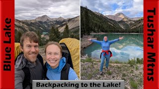
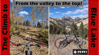
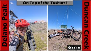
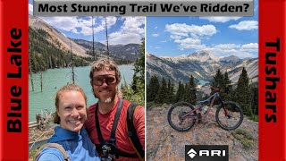
Thin air, rocky alpine trail, ridiculous views. You don't get to ride in many places like this outside of Colorado. Lower parts are in the forest on loose and soft tread with kind of a lot of pretty rideable log crossings. The climbing is technical but not crazy. Rideable, until it's not, and then rideable again. Mostly depends on your oxygen situation. The descending is technical and fun, if not all that fast. The satisfaction is in the location and the technicality. Be comfortable threading rocky side-hill moves. Or walk them. Exposure is not much of an issue but you don't want to throw caution to the wind. And the views are A-Mazing.

Trail Supporters

  • USFS
    Land Manager

Recent Activity on Trail

Past Week
  • 0 rides
  •  
6 Months
  • 0 rides
  •  
All
  • 2 rides
  • Last: Aug 2, 2025
c1c2c3c4
January
February
March
April
May
June
July
August
September
October
November
December
update trails status or condition

Blue Lake Trail Reports

statusdatedescription
Dec 10, 2021 @ 9:52pm
Dec 10, 2021
Rode Blue Lake Tr from S to N on 8/17/21. On the climb up there are lots of trees that have been down for a while you can ride over, and a few...
more »
Status:
on Dec 10, 2021
Avg: 4.1 (3 votes)
Your vote: 0

view (25)
close
3D
Trail Conditions
  • Unknown
  • Snow Groomed
  • Snow Packed
  • Snow Covered
  • Snow Cover Partial
  • Freeze/thaw Cycle
  • Icy
  • Prevalent Mud
  • Wet
  • Variable
  • Ideal
  • Dry
  • Very Dry
Trail Flow (Ridden Direction)
Trailforks scans users ridelogs to determine the most popular direction each trail is ridden. A good flowing trail network will have most trails flowing in a single direction according to their intension.
The colour categories are based on what percentage of riders are riding a trail in its intended direction.
  • > 96%
  • > 90%
  • > 80%
  • > 70%
  • > 50%
  • < 50%
  • bi-directional trail
  • no data
Trail Last Ridden
Trailforks scans ridelogs to determine the last time a trail was ridden.
  • < 2 days
  • < 1 week
  • < 2 weeks
  • < 1 month
  • < 6 months
  • > 6 months
Trail Ridden Direction
The intended direction a trail should be ridden.
  • Downhill Only
  • Downhill Primary
  • Both Directions
  • Uphill Primary
  • Uphill Only
  • One Direction
Contribute Details
Colors indicate trail is missing specified detail.
  • Description
  • Photos
  • Description & Photos
  • Videos
Trail Popularity ?
Trailforks scans ridelogs to determine which trails are ridden the most in the last 9 months. Trails are compared with nearby trails in the same city region with a possible 25 colour shades. Think of this as a heatmap, more rides = more kinetic energy = warmer colors.
  • most popular
  • popular
  • less popular
  • not popular
ATV/ORV/OHV Filter
Max Vehicle Width
inches
US Cell Coverage
Legend
cell carrier legend

Radar Time
Activity Recordings
Trailforks uses anonymized public activity data. ?
Activity Recordings
Trailforks uses anonymized public activity data. ?
Personal Heatmap
Activity Types
all / none
Options
2
Date range month
Winter Trails
Warning A routing network for winter maps does not exist. Selecting trails using the winter trails layer has been disabled.
Missing Trails
Most Popular
Least Popular
Trails are colored based on popularity. The more popular a trail is, the more red. Less popular trails trend towards green.
Jump Magnitude Heatmap
Heatmap of where riders jump on trails. Zoom in to see individual jumps, click circles to view jump details.
BC Backroad Status

Service Road Atlas is a free to use, community-driven service for viewing and creating reports on the numerous back-country service roads around B.C. and Alberta.

map legend
Slope Aspect
Direction the slope faces
Flat N NE E SE S SW W NW
Trails Deemphasized
Trails are shown in grey.
disable
Only show trails with no bike usage.
Enable
Suggested Layers
Based on selected activity type

    Save the current map location and zoom level as your default home location whenever this page is loaded.

    Save
        Directions to blue-lake trailhead (38.346800, -112.416190)

        Photos

        26 more »
        67 |
        Jul 1, 2024 @ 5:00pm
        Jul 1, 2024
        68 |
        Jul 1, 2024 @ 5:00pm
        Jul 1, 2024
        47 |
        Jul 1, 2024 @ 5:00pm
        Jul 1, 2024
        51 |
        Jul 1, 2024 @ 5:00pm
        Jul 1, 2024

        Videos

        5 more »
        youtuber Backpacking to the beautiful Blue Lake! |...
        31:55 | 73 | Jul 14, 2025 , Beaver
        youtuber North Creek Adventure (Part 1) - The Climb to...
        48:19 | 102 | Oct 25, 2024 , Beaver
        youtuber Epic Descent off Delano Peak to Duncan Creek!...
        41:06 | 87 | Aug 9, 2024 , Beaver
        youtuber Riding to the STUNNING Blue Lake! | Mountain...
        49:14 | 154 | Jul 15, 2024 , Beaver

        Routes with this trail

        62 miles 17,717 ft 12
        Tushars Mountain Run 100K course

        Reviews / Comments

        No reviews yet, be the first to write a review or ask a question.
        Use trail reports to comment on trail conditions.


        We hope you've been enjoying Trailforks!

        Create a FREE account to view trail comments and much more.

        • By Zach-Nielsen & contributors
        • #99455 - 4,072 views

        Frequently Asked Questions About Blue Lake

        Where is Blue Lake located?
        Blue Lake is located in Tushar Peaks, Beaver, Utah, United States. It is part of the Tushar Peaks trail network. The trailhead is located at coordinates 38.3468, -112.41619.
        How hard is Blue Lake?
        Blue Lake is rated as Black Diamond difficulty.
        What is the elevation gain for Blue Lake?
        Blue Lake has 1,610 ft of elevation gain. The trail has 1,594 ft of elevation descent. The elevation ranges from 9,662 ft to 11,152 ft.
        Is Blue Lake a point to point trail?
        Blue Lake is not a point to point trail. The direction is Downhill Primary. The trail type is singletrack.

        Hit the Trail

        Open in App

        Get this trail on your phone instantly.
        open trail in app

        Download Trail

        Save to wishlist, Garmin & download.
        save the trail

        Find Related Routes

        Find routes and users activities that include this trail.
        find routes for this trail

        You must enter a description before submitting.