more stats
1.1 miles
Distance
94 ft
Climb
-98 ft
Descent
00:10:07
Avg time
-3 ft
Altitude change
237 ft
Altitude min
308 ft
Altitude max
308 ft
Altitude start
305 ft
Altitude end
-0.1%
Grade
-13.9%
Grade max
19.6%
Grade min
2,320 ft
Distance climb
2,277 ft
Distance down
1,122 ft
Distance flat
00:10:07
Avg time

Blue Nuit Details

  • Activities
    • Mountain Bike
    • Winter Fat Bike
  • Riding Area
    Brookvale Mountain Bike Park
    Brookvale, Prince Edward Island
  • Difficulty Rating
  • Voted Difficulty
    Blue (2 votes)
  • Local Popularity
    100 in Mountain Biking
  • Global Ranking
    #32059 in Mountain Biking
  • Trail Type
    Machine Groomed
  • Bike Type
    AM, XC, DJ
  • Direction
    Downhill Only
  • Climb Difficulty
    Blue
  • Physical Rating
    Moderate
  • Trail Visibility
    Always easy to follow
  • Season
    3 season
  • Family Friendly
    Yes
  • eBike Allowed
  • TTFs on Trail
    Berm, Drop, Jump
  • Year Opened
    2017
  • Land Owner
    Parks PEI

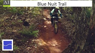
First opened in 2017, Bleu Nuit continues to develop each year. Packed with berms, rollers and jumps carved into PEI's famous red dirt, this trail is what Island riding is all about.

Access Info

Follow green loop then turn right to follow blue arrows

Trail Supporters

  • Joe downham

    since 2016
    Builder
  • John Mullins
    since 2016
    Builder
Traditionally Indigenous Territory

Recent Activity on Trail

Past Week
  • 4 rides
  • 12 miles average
6 Months
  • 21 rides
  • 9 miles avg distance
All
  • 652 rides
  • Last: Jun 17, 2026
c1c2c3c4
January
February
March
April
May
June
July
August
September
October
November
December
update trails status or condition

Blue Nuit Trail Reports

statusdatedescription
May 19, 2026 @ 12:34pm (America/Halifax)
May 19, 2026
Open for the season!
Dec 11, 2025 @ 10:34am (America/Halifax)
Dec 11, 2025
CLOSED FOR THE SEASON 24/11/2025
Sep 6, 2025 @ 10:48am
Sep 6, 2025
Jul 26, 2025 @ 5:11pm
Jul 26, 2025
Running awesome !
May 1, 2025 @ 8:33am
May 1, 2025
Open for the 2025 season. Watch out for updates!
more »
Status:
on May 19, 2026
Ideal
Avg: 4.59 (16 votes)
Your vote: 0

view (7,318)
close
3D
Trail Conditions
  • Unknown
  • Snow Groomed
  • Snow Packed
  • Snow Covered
  • Snow Cover Partial
  • Freeze/thaw Cycle
  • Icy
  • Prevalent Mud
  • Wet
  • Variable
  • Ideal
  • Dry
  • Very Dry
Trail Flow (Ridden Direction)
Trailforks scans users ridelogs to determine the most popular direction each trail is ridden. A good flowing trail network will have most trails flowing in a single direction according to their intension.
The colour categories are based on what percentage of riders are riding a trail in its intended direction.
  • > 96%
  • > 90%
  • > 80%
  • > 70%
  • > 50%
  • < 50%
  • bi-directional trail
  • no data
Trail Last Ridden
Trailforks scans ridelogs to determine the last time a trail was ridden.
  • < 2 days
  • < 1 week
  • < 2 weeks
  • < 1 month
  • < 6 months
  • > 6 months
Trail Ridden Direction
The intended direction a trail should be ridden.
  • Downhill Only
  • Downhill Primary
  • Both Directions
  • Uphill Primary
  • Uphill Only
  • One Direction
Contribute Details
Colors indicate trail is missing specified detail.
  • Description
  • Photos
  • Description & Photos
  • Videos
Trail Popularity ?
Trailforks scans ridelogs to determine which trails are ridden the most in the last 9 months. Trails are compared with nearby trails in the same city region with a possible 25 colour shades. Think of this as a heatmap, more rides = more kinetic energy = warmer colors.
  • most popular
  • popular
  • less popular
  • not popular
ATV/ORV/OHV Filter
Max Vehicle Width
inches
US Cell Coverage
Legend
cell carrier legend

Radar Time
Activity Recordings
Trailforks uses anonymized public activity data. ?
Activity Recordings
Trailforks uses anonymized public activity data. ?
Personal Heatmap
Activity Types
all / none
Options
2
Date range month
Winter Trails
Warning A routing network for winter maps does not exist. Selecting trails using the winter trails layer has been disabled.
Missing Trails
Most Popular
Least Popular
Trails are colored based on popularity. The more popular a trail is, the more red. Less popular trails trend towards green.
Jump Magnitude Heatmap
Heatmap of where riders jump on trails. Zoom in to see individual jumps, click circles to view jump details.
BC Backroad Status

Service Road Atlas is a free to use, community-driven service for viewing and creating reports on the numerous back-country service roads around B.C. and Alberta.

map legend
Slope Aspect
Direction the slope faces
Flat N NE E SE S SW W NW
Trails Deemphasized
Trails are shown in grey.
disable
Only show trails with no bike usage.
Enable
Suggested Layers
Based on selected activity type

    Save the current map location and zoom level as your default home location whenever this page is loaded.

    Save
        Directions to blue-nuit trailhead (46.270180, -63.425670)

        Photos

        8 more »
        106 |
        May 14, 2024 @ 4:46pm
        May 14, 2024
        99 |
        May 14, 2024 @ 4:46pm
        May 14, 2024
        87 |
        May 14, 2024 @ 4:45pm
        May 14, 2024
        84 |
        May 14, 2024 @ 4:45pm
        May 14, 2024

        Videos

        6 more »
        Blue Nuit - Brookvale Prince Edward Island
        2:18 | 198 | Aug 9, 2024 , Brookvale
        Blue Nuit Trail  Moderate @ Brookvale PEI
        2:17 | 666 | Mar 31, 2020 , Brookvale
        Brookvale PEI Blue Loop POV
        3:48 | 579 | Oct 6, 2019 , Brookvale
        Bleu Nuit 2018 - Brookvale PEI
        0:45 | 781 | Jan 4, 2019 , Brookvale

        Routes with this trail

        52 miles 4,710 ft 65
        start is at DAY PARK in Bonshaw -ROUND TRIP , St Kitz to Strath, to Bonshaw, to Appin east then west, CTO...

        5 Reviews & Comments


        We hope you've been enjoying Trailforks!

        Create a FREE account to view trail comments and much more.

        • By jdownhamTF Pro PARKSPEI & contributors
        • #95733 - 4,421 views

        Frequently Asked Questions About Blue Nuit

        Where is Blue Nuit located?
        Blue Nuit is located in Brookvale Mountain Bike Park, Brookvale, Prince Edward Island, Canada. It is part of the Brookvale Mountain Bike Park trail network. The trailhead is located at coordinates 46.27018, -63.42567.
        How hard is Blue Nuit?
        Blue Nuit is rated as Blue difficulty. The physical rating is Moderate. The average grade is 0.1%. The climb difficulty is rated Blue.
        What is the elevation gain for Blue Nuit?
        Blue Nuit has 94 ft of elevation gain. The trail has 98 ft of elevation descent. The elevation ranges from 237 ft to 308 ft.
        Is Blue Nuit a point to point trail?
        Yes, Blue Nuit is a point to point trail. The direction is Downhill Only. The trail type is machine groomed.

        Hit the Trail

        Open in App

        Get this trail on your phone instantly.
        open trail in app

        Download Trail

        Save to wishlist, Garmin & download.
        save the trail

        Find Related Routes

        Find routes and users activities that include this trail.
        find routes for this trail

        You must enter a description before submitting.