more stats
4,738 ft
Distance
-327 ft
Descent
00:02:46
Avg time
-327 ft
Altitude change
1,190 ft
Altitude min
1,518 ft
Altitude max
1,517 ft
Altitude start
1,191 ft
Altitude end
-6.9%
Grade
-27.8%
Grade max
1.4%
Grade min
66 ft
Distance climb
3,753 ft
Distance down
892 ft
Distance flat
00:02:46
Avg time

Blue Pulaski Details

  • Activities
    • Mountain Bike
  • Riding Area
    Thunder Mountain Bike Park
    Charlemont, Massachusetts
  • Difficulty Rating
  • Voted Difficulty
    Blue (2 votes)
  • Local Popularity
    75 in Mountain Biking
  • Global Ranking
    #1936 in Mountain Biking
  • Trail Type
    Singletrack
  • Bike Type
    DH, AM
  • eBike Allowed
  • Land Owner
    Jon Schaefer

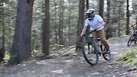
Great flow trail with big wide flowing berms. May be in between easy and intermediate. some of the berms have some embedded rocks. Nice little air out spots between the turns. With the ride speed a bit of hangtime is possible. It gets a bit chunky as you near the big intersection

Bike Park

Local Trail Association
Traditionally Indigenous Territory

Recent Activity on Trail

Past Week
  • 11 rides
  • 24 miles average
6 Months
  • 59 rides
  • 29 miles avg distance
All
  • 1,818 rides
  • Last: Jun 18, 2026
c1c2c3c4
January
February
March
April
May
June
July
August
September
October
November
December
Status:
on Jun 7, 2026
Ideal
Avg: 4 (10 votes)
Your vote: 0

view (19,837)
close
3D
Trail Conditions
  • Unknown
  • Snow Groomed
  • Snow Packed
  • Snow Covered
  • Snow Cover Partial
  • Freeze/thaw Cycle
  • Icy
  • Prevalent Mud
  • Wet
  • Variable
  • Ideal
  • Dry
  • Very Dry
Trail Flow (Ridden Direction)
Trailforks scans users ridelogs to determine the most popular direction each trail is ridden. A good flowing trail network will have most trails flowing in a single direction according to their intension.
The colour categories are based on what percentage of riders are riding a trail in its intended direction.
  • > 96%
  • > 90%
  • > 80%
  • > 70%
  • > 50%
  • < 50%
  • bi-directional trail
  • no data
Trail Last Ridden
Trailforks scans ridelogs to determine the last time a trail was ridden.
  • < 2 days
  • < 1 week
  • < 2 weeks
  • < 1 month
  • < 6 months
  • > 6 months
Trail Ridden Direction
The intended direction a trail should be ridden.
  • Downhill Only
  • Downhill Primary
  • Both Directions
  • Uphill Primary
  • Uphill Only
  • One Direction
Contribute Details
Colors indicate trail is missing specified detail.
  • Description
  • Photos
  • Description & Photos
  • Videos
Trail Popularity ?
Trailforks scans ridelogs to determine which trails are ridden the most in the last 9 months. Trails are compared with nearby trails in the same city region with a possible 25 colour shades. Think of this as a heatmap, more rides = more kinetic energy = warmer colors.
  • most popular
  • popular
  • less popular
  • not popular
ATV/ORV/OHV Filter
Max Vehicle Width
inches
US Cell Coverage
Legend
cell carrier legend

Radar Time
Activity Recordings
Trailforks uses anonymized public activity data. ?
Activity Recordings
Trailforks uses anonymized public activity data. ?
Personal Heatmap
Activity Types
all / none
Options
2
Date range month
Winter Trails
Warning A routing network for winter maps does not exist. Selecting trails using the winter trails layer has been disabled.
Missing Trails
Most Popular
Least Popular
Trails are colored based on popularity. The more popular a trail is, the more red. Less popular trails trend towards green.
Jump Magnitude Heatmap
Heatmap of where riders jump on trails. Zoom in to see individual jumps, click circles to view jump details.
BC Backroad Status

Service Road Atlas is a free to use, community-driven service for viewing and creating reports on the numerous back-country service roads around B.C. and Alberta.

map legend
Slope Aspect
Direction the slope faces
Flat N NE E SE S SW W NW
Trails Deemphasized
Trails are shown in grey.
disable
Only show trails with no bike usage.
Enable
Suggested Layers
Based on selected activity type

    Save the current map location and zoom level as your default home location whenever this page is loaded.

    Save
        Directions to blue-pulaski trailhead (42.614020, -72.869810)

        Photos

        1 more »
        303 |
        May 30, 2016 @ 1:13pm
        May 30, 2016

        Videos

        4 more »
        Back of the Shack to Blue Pulaski
        3:18 | 549 | Jul 29, 2019 , Charlemont
        Thunder Mountain Pre Season
        0:39 | | May 20, 2024 , Charlemont
        Blue Pulaski to Hawleywood at Thunder Mountain...
        6:15 | 162 | Jun 17, 2016 , Charlemont
        Thunder
        7:40 | 84 | Sep 26, 2015 , Charlemont

        1 Review & Comments


        We hope you've been enjoying Trailforks!

        Create a FREE account to view trail comments and much more.

        • By Jdam149 & contributors
        • #34046 - 3,035 views

        Frequently Asked Questions About Blue Pulaski

        Where is Blue Pulaski located?
        Blue Pulaski is located in Thunder Mountain Bike Park, Charlemont, Massachusetts, United States. It is part of the Thunder Mountain Bike Park trail network. The trailhead is located at coordinates 42.61402, -72.86981.
        How hard is Blue Pulaski?
        Blue Pulaski is rated as Blue difficulty. The average grade is 6.9%.
        What is the elevation gain for Blue Pulaski?
        The trail has 327 ft of elevation descent. The elevation ranges from 1,190 ft to 1,518 ft.
        How long is Blue Pulaski?
        Blue Pulaski is 4,738 ft long. The trail type is singletrack.

        Hit the Trail

        Open in App

        Get this trail on your phone instantly.
        open trail in app

        Download Trail

        Save to wishlist, Garmin & download.
        save the trail

        Find Related Routes

        Find routes and users activities that include this trail.
        find routes for this trail

        You must enter a description before submitting.