more stats
807 ft
Distance
-118 ft
Descent
00:01:36
Avg time
-119 ft
Altitude change
2,859 ft
Altitude min
2,978 ft
Altitude max
2,978 ft
Altitude start
2,858 ft
Altitude end
-14.8%
Grade
-24.3%
Grade max
-3.6%
Grade min
13 ft
Distance climb
692 ft
Distance down
102 ft
Distance flat
00:01:36
Avg time

Blueseum Details

  • Activities
    • Mountain Bike
  • Riding Area
    Whistler Mountain Bike Park
    Whistler, British Columbia
  • Difficulty Rating
  • Local Popularity
    85 in Mountain Biking
  • Global Ranking
    #834 in Mountain Biking
  • Trail Type
    Singletrack
  • Bike Type
    DH, AM
  • Direction
    Downhill Only
    Popular Direction Shown
  • Physical Rating
    Moderate
  • Season
    May - Oct
  • TTFs on Trail
    Bridge, Rock Face
  • Land Owner

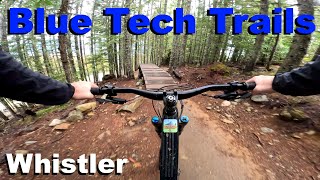
Technical singletrack with bridges and a rock roll (with optional ride around).

Access Info

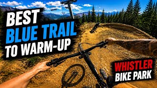
Lower Whistler Bike Park. Accessible from Smoke and Mirrors or cutting through the second big right berm on B-Line.

Bike Park

Recent Activity on Trail

Past Week
  • 67 rides
  • 22 miles average
6 Months
  • 329 rides
  • 21 miles avg distance
All
  • 4,594 rides
  • Last: Jun 19, 2026
c1c2c3c4
January
February
March
April
May
June
July
August
September
October
November
December
Status:
on Jun 14, 2026
Ideal
Avg: 4.41 (62 votes)
Your vote: 0

view (29,103)
close
3D
Trail Conditions
  • Unknown
  • Snow Groomed
  • Snow Packed
  • Snow Covered
  • Snow Cover Partial
  • Freeze/thaw Cycle
  • Icy
  • Prevalent Mud
  • Wet
  • Variable
  • Ideal
  • Dry
  • Very Dry
Trail Flow (Ridden Direction)
Trailforks scans users ridelogs to determine the most popular direction each trail is ridden. A good flowing trail network will have most trails flowing in a single direction according to their intension.
The colour categories are based on what percentage of riders are riding a trail in its intended direction.
  • > 96%
  • > 90%
  • > 80%
  • > 70%
  • > 50%
  • < 50%
  • bi-directional trail
  • no data
Trail Last Ridden
Trailforks scans ridelogs to determine the last time a trail was ridden.
  • < 2 days
  • < 1 week
  • < 2 weeks
  • < 1 month
  • < 6 months
  • > 6 months
Trail Ridden Direction
The intended direction a trail should be ridden.
  • Downhill Only
  • Downhill Primary
  • Both Directions
  • Uphill Primary
  • Uphill Only
  • One Direction
Contribute Details
Colors indicate trail is missing specified detail.
  • Description
  • Photos
  • Description & Photos
  • Videos
Trail Popularity ?
Trailforks scans ridelogs to determine which trails are ridden the most in the last 9 months. Trails are compared with nearby trails in the same city region with a possible 25 colour shades. Think of this as a heatmap, more rides = more kinetic energy = warmer colors.
  • most popular
  • popular
  • less popular
  • not popular
ATV/ORV/OHV Filter
Max Vehicle Width
inches
US Cell Coverage
Legend
cell carrier legend

Radar Time
Activity Recordings
Trailforks uses anonymized public activity data. ?
Activity Recordings
Trailforks uses anonymized public activity data. ?
Personal Heatmap
Activity Types
all / none
Options
2
Date range month
Winter Trails
Warning A routing network for winter maps does not exist. Selecting trails using the winter trails layer has been disabled.
Missing Trails
Most Popular
Least Popular
Trails are colored based on popularity. The more popular a trail is, the more red. Less popular trails trend towards green.
Jump Magnitude Heatmap
Heatmap of where riders jump on trails. Zoom in to see individual jumps, click circles to view jump details.
BC Backroad Status

Service Road Atlas is a free to use, community-driven service for viewing and creating reports on the numerous back-country service roads around B.C. and Alberta.

map legend
Slope Aspect
Direction the slope faces
Flat N NE E SE S SW W NW
Trails Deemphasized
Trails are shown in grey.
disable
Only show trails with no bike usage.
Enable
Suggested Layers
Based on selected activity type

    Save the current map location and zoom level as your default home location whenever this page is loaded.

    Save
        Directions to blueseum trailhead (50.103520, -122.955770)

        Photos

        35 more »
        247 |
        Jul 15, 2017 @ 4:11pm
        Jul 15, 2017
        280 |
        Nov 15, 2016 @ 7:20am
        Nov 15, 2016
        367 |
        Dec 4, 2016 @ 12:45pm
        Dec 4, 2016
        1,020 |
        Jun 18, 2015 @ 8:35am
        Jun 18, 2015

        Videos

        26 more »
        youtuber Best Blue Trails to Warm Up at Whistler Bike Park
        12:24 | 45 | May 22, 2026 , Whistler
        Blue Tech Trails - Whistler 2025
        7:50 | 94 | Oct 26, 2025 , Whistler
        youtuber 3 Best Blue Routes Down The Whistler Bike...
        31:44 | 76 | Oct 7, 2025 , Whistler
        Whistler June 2022 - Blueseum (4K!!!!!!!!!)
        0:04 | 315 | Aug 11, 2022 , Whistler

        Trail Lists

        Routes with this trail

        2 miles 28 ft 6
        Brake Test Lap
        5 miles 1,249 ft 26
        Bike park Ride!! Start - Yellow gate at access road. Access Road UP Singing Pass UP to Crank it up...
        1 mile 14 ft 5

        1 Review & Comments


        We hope you've been enjoying Trailforks!

        Create a FREE account to view trail comments and much more.

        • By mabes1 & contributors
        • #5109 - 8,519 views

        Frequently Asked Questions About Blueseum

        Where is Blueseum located?
        Blueseum is located in Whistler Mountain Bike Park, Whistler, British Columbia, Canada. It is part of the Whistler Mountain Bike Park trail network. The trailhead is located at coordinates 50.10352, -122.95577.
        How hard is Blueseum?
        Blueseum is rated as Blue difficulty. The physical rating is Moderate. The average grade is 14.8%.
        What is the elevation gain for Blueseum?
        The trail has 118 ft of elevation descent. The elevation ranges from 2,859 ft to 2,978 ft.
        Is Blueseum a point to point trail?
        Yes, Blueseum is a point to point trail. The direction is Downhill Only. The trail type is singletrack.

        Hit the Trail

        Open in App

        Get this trail on your phone instantly.
        open trail in app

        Download Trail

        Save to wishlist, Garmin & download.
        save the trail

        Find Related Routes

        Find routes and users activities that include this trail.
        find routes for this trail

        You must enter a description before submitting.