more stats
2.1 miles
Distance
276 ft
Climb
-59 ft
Descent
00:22:19
Avg time
219 ft
Altitude change
432 ft
Altitude min
655 ft
Altitude max
435 ft
Altitude start
653 ft
Altitude end
2%
Grade
-11.1%
Grade max
18.9%
Grade min
1 mile
Distance climb
2,687 ft
Distance down
1,637 ft
Distance flat
00:22:19
Avg time

Bluff View Details

  • Activities
    • Mountain Bike
    • Hike
    • Trail Running
  • Riding Area
    Rock Hollow
    Wildwood, Missouri
  • Difficulty Rating
  • Local Popularity
    50 in Mountain Biking [+]
    • 95 in Trail Running
    • 55 in Hiking
  • Global Ranking
    #12355 in Mountain Biking [+]
    • #27227 in Trail Running
    • #52559 in Hiking
  • Trail Type
    Singletrack
  • Bike Type
    XC
  • Direction
    Both Directions
  • Climb Difficulty
    Blue
  • Physical Rating
    Moderate
  • Dogs Allowed
    Yes
  • Year Opened
    2012
  • Land Owner

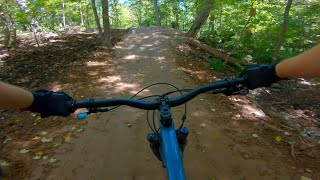
Bluff View is the newest addition to the St. Louis county network of trails. This 5 mile round-trip singletrack trail was built in 2012 by GORC and Americorps volunteers. The Bluff View trail features some rocky outcroppings, sustained climbs and descents and beautiful terrain. The trail's namesake will make you stop in your tracks to take in the expansive view of the Meramec river and Crescent Valley. If you know where to look you can pick out hints of the Chubb trail hillsides and a section of the Al Foster.

Access Info

Access to Bluff View Park is via Old State Road. The entrance is 6/10ths of a mile east of the intersection of Highway 109 and Old State Road (1900 Old State Road).

Trail Supporters
Local Trail Association

Recent Activity on Trail

Past Week
  • 1 rides
  • 28 miles average
6 Months
  • 24 rides
  • 20 miles avg distance
All
  • 334 rides
  • Last: Jun 15, 2026
c1c2c3c4
January
February
March
April
May
June
July
August
September
October
November
December
update trails status or condition

Bluff View Trail Reports

statusdatedescription
Mar 24, 2025 @ 10:54am
Mar 24, 2025
so far only about halfway through but it's pretty muddy, especially down at the bottom, tires are caked. I wish I knew where to go to get trail...
Feb 3, 2024 @ 7:06pm
Feb 3, 2024
trail is in decent shape but there is a massive tree down at about the 1/2 mile mark from the bottom.
Feb 5, 2023 @ 3:55pm
Feb 5, 2023
a solute muddy mess. stay far away.
Jan 1, 2023 @ 6:20pm
Jan 1, 2023
some damp spots but overall very good shape for this time of year.
Dec 25, 2022 @ 12:52pm
Dec 25, 2022
great shape, snow covered but dry and good to go. only one icy spot.
more »
Status:
on Mar 24, 2025
Wet
Avg: 4.26 (9 votes)
Your vote: 0

view (2,861)
close
3D
Trail Conditions
  • Unknown
  • Snow Groomed
  • Snow Packed
  • Snow Covered
  • Snow Cover Partial
  • Freeze/thaw Cycle
  • Icy
  • Prevalent Mud
  • Wet
  • Variable
  • Ideal
  • Dry
  • Very Dry
Trail Flow (Ridden Direction)
Trailforks scans users ridelogs to determine the most popular direction each trail is ridden. A good flowing trail network will have most trails flowing in a single direction according to their intension.
The colour categories are based on what percentage of riders are riding a trail in its intended direction.
  • > 96%
  • > 90%
  • > 80%
  • > 70%
  • > 50%
  • < 50%
  • bi-directional trail
  • no data
Trail Last Ridden
Trailforks scans ridelogs to determine the last time a trail was ridden.
  • < 2 days
  • < 1 week
  • < 2 weeks
  • < 1 month
  • < 6 months
  • > 6 months
Trail Ridden Direction
The intended direction a trail should be ridden.
  • Downhill Only
  • Downhill Primary
  • Both Directions
  • Uphill Primary
  • Uphill Only
  • One Direction
Contribute Details
Colors indicate trail is missing specified detail.
  • Description
  • Photos
  • Description & Photos
  • Videos
Trail Popularity ?
Trailforks scans ridelogs to determine which trails are ridden the most in the last 9 months. Trails are compared with nearby trails in the same city region with a possible 25 colour shades. Think of this as a heatmap, more rides = more kinetic energy = warmer colors.
  • most popular
  • popular
  • less popular
  • not popular
ATV/ORV/OHV Filter
Max Vehicle Width
inches
US Cell Coverage
Legend
cell carrier legend

Radar Time
Activity Recordings
Trailforks uses anonymized public activity data. ?
Activity Recordings
Trailforks uses anonymized public activity data. ?
Personal Heatmap
Activity Types
all / none
Options
2
Date range month
Winter Trails
Warning A routing network for winter maps does not exist. Selecting trails using the winter trails layer has been disabled.
Missing Trails
Most Popular
Least Popular
Trails are colored based on popularity. The more popular a trail is, the more red. Less popular trails trend towards green.
Jump Magnitude Heatmap
Heatmap of where riders jump on trails. Zoom in to see individual jumps, click circles to view jump details.
BC Backroad Status

Service Road Atlas is a free to use, community-driven service for viewing and creating reports on the numerous back-country service roads around B.C. and Alberta.

map legend
Slope Aspect
Direction the slope faces
Flat N NE E SE S SW W NW
Trails Deemphasized
Trails are shown in grey.
disable
Only show trails with no bike usage.
Enable
Suggested Layers
Based on selected activity type

    Save the current map location and zoom level as your default home location whenever this page is loaded.

    Save
        Directions to bluff-view trailhead (38.542920, -90.618670)

        Photos

        23 more »
        21 |
        Apr 14, 2026 @ 5:11pm
        Apr 14, 2026
        37 |
        Oct 23, 2024 @ 4:40pm
        Oct 23, 2024
        110 |
        Sep 9, 2021 @ 1:55pm
        Sep 9, 2021
        105 |
        Mar 1, 2021 @ 12:10am
        Mar 1, 2021

        Videos

        4 more »
        Best Flow Trail in STL - Bluff View Downhill Trail
        3:43 | 588 | Oct 2, 2021 , Wildwood
        Bluff View DH
        4:14 | 450 | Nov 4, 2020 , Wildwood
        Bluff View Trail, Wildwood, MO
        14:01 | 835 | Oct 22, 2019 , Wildwood
        Back Home
        0:24 | 247 | Sep 22, 2015 , Wildwood

        Routes with this trail

        4.0 13 miles 1,031 ft 9
        parking lot to the zombies back thru bluff to parking lot
        14 miles 1,075 ft 4 Out & Back
        Starting at Glencoe Great Rivers Greenway parking lot and going to Sherman Beach it uses Al Foster & paved...
        52 miles 3,706 ft 14
        Rock Hollow to Castlewood and Back

        Trail Events

        2 Reviews & Comments


        We hope you've been enjoying Trailforks!

        Create a FREE account to view trail comments and much more.

        • By pilznrTF Pro GORC & contributors
        • #35155 - 7,452 views

        Frequently Asked Questions About Bluff View

        Where is Bluff View located?
        Bluff View is located in Rock Hollow, Wildwood, Missouri, United States. It is part of the Rock Hollow trail network. The trailhead is located at coordinates 38.54292, -90.61867.
        How hard is Bluff View?
        Bluff View is rated as Blue difficulty. The physical rating is Moderate. The average grade is 2%. The climb difficulty is rated Blue.
        What is the elevation gain for Bluff View?
        Bluff View has 276 ft of elevation gain. The trail has 59 ft of elevation descent. The elevation ranges from 432 ft to 655 ft.
        Is Bluff View a point to point trail?
        Bluff View is not a point to point trail. The direction is Both Directions. The trail type is singletrack.

        Hit the Trail

        Open in App

        Get this trail on your phone instantly.
        open trail in app

        Download Trail

        Save to wishlist, Garmin & download.
        save the trail

        Find Related Routes

        Find routes and users activities that include this trail.
        find routes for this trail

        You must enter a description before submitting.