more stats
2.5 miles
Distance
1,022 ft
Climb
-131 ft
Descent
00:39:27
Avg time
891 ft
Altitude change
4,698 ft
Altitude min
5,590 ft
Altitude max
4,698 ft
Altitude start
5,591 ft
Altitude end
6.6%
Grade
-25.2%
Grade max
56.9%
Grade min
2 miles
Distance climb
1,844 ft
Distance down
459 ft
Distance flat
00:39:27
Avg time

Bobcat Details

  • Activities
    • Mountain Bike
    • E-Bike
    • Winter Fat Bike
    • Horse
    • Hike
    • Trail Running
    • Snowshoe
  • Riding Area
    West Bragg Creek
    Bragg Creek, Alberta
  • AKA
    Bob Cat
  • Difficulty Rating
  • Voted Difficulty
    Blue (2 votes)
  • Local Popularity
    90 in Mountain Biking [+]
    • 100 in E-Biking
    • 90 in Trail Running
    • 50 in Hiking
    • 5 in Horseback
  • Global Ranking
    #534 in Mountain Biking [+]
    • #5862 in E-Biking
    • #5125 in Trail Running
    • #107900 in Hiking
    • #1032 in Horseback
  • Hiking SAC Scale
    T1 Hiking
  • Trail Type
    Singletrack
  • Snow Grooming
    Backcountry
  • Bike Type
    AM, XC, Fat
  • Direction
    Both Directions[+]
    • Both Directions for Snowshoeing
    • Both Directions for Winter Fat Biking
  • Climb Difficulty
    Blue
  • Physical Rating
    Moderate
  • Trail Visibility
    Sometimes hard to follow
  • Dogs Allowed
    Yes
  • eBike Allowed
    Yes up to Class 1
  • TTFs on Trail
    Berm, Bridge, Jump
  • Lighting
    No
  • Year Opened
    2013
  • Land Owner
    Alberta Forestry and Parks

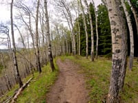
This has become an extremely popular climbing trail for people accessing West Bragg trails from Station Flats / Allen Bill, and riders looping back to West Bragg after descending Ridgeback 3. The trail is fairly smooth, with few roots and loose rocks except at the very bottom and top of the trail. However, it is also an incredibly fun descent...

From Ranger Summit, drop down Bobcat through a rooty, fast and tight trail in old growth and past the Sugar Mama intersection. Continue down through more old growth, before popping out into an aspen rimmed meadow and the Fullerton Loop/Bobcat intersection. This section of the trail provides some of the best views of West Bragg, with the meadow opening up and looking over the entire Elbow Valley. Enjoy a fast paced rip across the bottom of the meadow and start into the rollers that descend the ridge line. The trail switches into a Berm Barista, serving up corner after corner until it climaxes in the bipolar toilet bowl, alternating between clockwise and counter clockwise flushes. Enjoy a final fast paced exit through Moo-Moo Meadows [watch for cows and their deposits] and over some bridges before getting spit out at the junction with Ridgeback. From here you have several options to return to West Bragg Parking, or continue through to Station Flats Parking, or link to some of the Moose Mountain Trails.

Access Info

From the bottom, access is a signed junction between Ridgeback 2 and Ridgeback 3.
From the top: take Ranger Summit or Strange Brew to the Bobcat intersection, just west of Baruch's Corner summit lounge.

Local Trail Association

Recent Activity on Trail

Past Week
  • 17 rides
  • 20 miles average
6 Months
  • 75 rides
  • 15 miles avg distance
All
  • 1,719 rides
  • Last: Jun 25, 2026
c1c2c3c4
January
February
March
April
May
June
July
August
September
October
November
December
update trails status or condition

Bobcat Trail Reports

statusdatedescription
Jun 14, 2026 @ 12:08pm (America/Creston)
Jun 14, 2026
Jun 13, 2026 @ 9:59am (America/Creston)
Jun 13, 2026
A few muddy sections but overall pretty good.
Jun 9, 2026 @ 11:10am (America/Edmonton)
Jun 9, 2026
Rode June 7, good to go. Couple of muddy spots before the small bridges where the trail wends its way riders’ left up the first meadow (via the...
Jun 7, 2026 @ 12:04pm (America/Edmonton)
Jun 7, 2026
May 6, 2026 @ 1:35pm (America/Edmonton)
May 6, 2026
more »
Status:
on Jun 14, 2026
Variable
Avg: 4.36 (39 votes)
Your vote: 0

view (10,755)
close
3D
Trail Conditions
  • Unknown
  • Snow Groomed
  • Snow Packed
  • Snow Covered
  • Snow Cover Partial
  • Freeze/thaw Cycle
  • Icy
  • Prevalent Mud
  • Wet
  • Variable
  • Ideal
  • Dry
  • Very Dry
Trail Flow (Ridden Direction)
Trailforks scans users ridelogs to determine the most popular direction each trail is ridden. A good flowing trail network will have most trails flowing in a single direction according to their intension.
The colour categories are based on what percentage of riders are riding a trail in its intended direction.
  • > 96%
  • > 90%
  • > 80%
  • > 70%
  • > 50%
  • < 50%
  • bi-directional trail
  • no data
Trail Last Ridden
Trailforks scans ridelogs to determine the last time a trail was ridden.
  • < 2 days
  • < 1 week
  • < 2 weeks
  • < 1 month
  • < 6 months
  • > 6 months
Trail Ridden Direction
The intended direction a trail should be ridden.
  • Downhill Only
  • Downhill Primary
  • Both Directions
  • Uphill Primary
  • Uphill Only
  • One Direction
Contribute Details
Colors indicate trail is missing specified detail.
  • Description
  • Photos
  • Description & Photos
  • Videos
Trail Popularity ?
Trailforks scans ridelogs to determine which trails are ridden the most in the last 9 months. Trails are compared with nearby trails in the same city region with a possible 25 colour shades. Think of this as a heatmap, more rides = more kinetic energy = warmer colors.
  • most popular
  • popular
  • less popular
  • not popular
ATV/ORV/OHV Filter
Max Vehicle Width
inches
US Cell Coverage
Legend
cell carrier legend

Radar Time
Activity Recordings
Trailforks uses anonymized public activity data. ?
Activity Recordings
Trailforks uses anonymized public activity data. ?
Personal Heatmap
Activity Types
all / none
Options
2
Date range month
Winter Trails
Warning A routing network for winter maps does not exist. Selecting trails using the winter trails layer has been disabled.
Missing Trails
Most Popular
Least Popular
Trails are colored based on popularity. The more popular a trail is, the more red. Less popular trails trend towards green.
Jump Magnitude Heatmap
Heatmap of where riders jump on trails. Zoom in to see individual jumps, click circles to view jump details.
BC Backroad Status

Service Road Atlas is a free to use, community-driven service for viewing and creating reports on the numerous back-country service roads around B.C. and Alberta.

map legend
Slope Aspect
Direction the slope faces
Flat N NE E SE S SW W NW
Trails Deemphasized
Trails are shown in grey.
disable
Only show trails with no bike usage.
Enable
Suggested Layers
Based on selected activity type

    Save the current map location and zoom level as your default home location whenever this page is loaded.

    Save
        Directions to bobcat trailhead (50.910720, -114.708160)

        Photos

        32 more »
        308 |
        Apr 18, 2021 @ 12:28pm
        Apr 18, 2021
        1,187 |
        Jun 15, 2015 @ 11:49am
        Jun 15, 2015
        74 |
        Jun 24, 2023 @ 9:00pm
        Jun 24, 2023
        281 |
        Apr 18, 2021 @ 12:28pm
        Apr 18, 2021

        Videos

        3 more »
        Mountain Biking Bragg Creek,  Alberta, South...
        21:35 | 87 | May 26, 2025 , Bragg Creek
        Bobcat trail West Bragg
        2084 | Jun 11, 2016 , Bragg Creek
        West Bragg Creek | Self Shot GoPro | Apr 26, 2016
        971 | Apr 30, 2016 , Bragg Creek

        Routes with this trail

        4.8 13 miles 2,246 ft 7 Loop
        A fun easy loop. I recommend riding counter clockwise. This is also the route for the 2016 Provincial XC...
        4.0 13 miles 2,322 ft 14 Loop
        A loop to do Snakes and Ladders from WBC parking lot.
        5.0 11 miles 1,919 ft 8 Out & Back
        Up , out and back on then down A nice short way to do

        3 Reviews & Comments


        We hope you've been enjoying Trailforks!

        Create a FREE account to view trail comments and much more.

        Frequently Asked Questions About Bobcat

        Where is Bobcat located?
        Bobcat is located in West Bragg Creek, Bragg Creek, Alberta, Canada. It is part of the West Bragg Creek trail network. The trailhead is located at coordinates 50.91072, -114.70816.
        How hard is Bobcat?
        Bobcat is rated as Blue difficulty. The physical rating is Moderate. The average grade is 6.6%. The climb difficulty is rated Blue.
        What is the elevation gain for Bobcat?
        Bobcat has 1,022 ft of elevation gain. The trail has 131 ft of elevation descent. The elevation ranges from 4,698 ft to 5,590 ft.
        Is Bobcat a point to point trail?
        Bobcat is not a point to point trail. The direction is Both Directions. The trail type is singletrack.

        Hit the Trail

        Open in App

        Get this trail on your phone instantly.
        open trail in app

        Download Trail

        Save to wishlist, Garmin & download.
        save the trail

        Find Related Routes

        Find routes and users activities that include this trail.
        find routes for this trail

        You must enter a description before submitting.