more stats
2.2 miles
Distance
271 ft
Climb
-358 ft
Descent
00:26:49
Avg time
-87 ft
Altitude change
732 ft
Altitude min
1,021 ft
Altitude max
1,021 ft
Altitude start
935 ft
Altitude end
-0.7%
Grade
-26.3%
Grade max
23.6%
Grade min
4,938 ft
Distance climb
4,849 ft
Distance down
1,936 ft
Distance flat
00:26:49
Avg time

BOBCAT Details

  • Activities
    • Mountain Bike
    • E-Bike
    • Winter Fat Bike
    • Hike
    • Trail Running
  • Riding Area
    Brown County State Park
    Nashville, Indiana
  • Ref Number
    (J)
  • AKA
    Bobcat Bowl
  • Difficulty Rating
  • Voted Difficulty
    Black Diamond (1 vote)
  • Local Popularity
    90 in Mountain Biking [+]
    • 75 in E-Biking
    • 5 in Trail Running
    • 5 in Hiking
  • Global Ranking
    #43410 in Mountain Biking [+]
    • #24537 in E-Biking
    • #128315 in Trail Running
    • #121398 in Hiking
  • Trail Exposure
    High Risk
  • Blaze Color
  • Trail Type
    Singletrack
  • Bike Type
    DH, AM, XC, Fat
  • Climb Difficulty
    Black Diamond
  • Physical Rating
    Hard
  • Trail Visibility
    Always easy to follow
  • Dogs Allowed
    Yes
  • eBike Allowed
    Yes up to Class 1
  • TTFs on Trail
    Bridge, Rock Garden, Skinny, Other
  • Land Owner
    Brown County

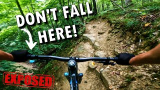
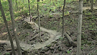
Bobcat is an expert level trail that features narrow singletrack, rocks, narrow bridges, and a long climb/descent. Starting near Weedpatch Hill (the highest point in Brown County State Park) and dropping deep into Fern Valley below, the trail features 250 feet of elevation change.

While the entrance near Weedpatch is a show case piece machine-built by Spectrum Trail D, the rest of the trail has been hand built to ensure a rugged old school vibe.

Disclaimer

Steep climbs with some exposure.

Trail Supporters
  • Sponsor
Local Trail Association

Recent Activity on Trail

Past Week
  • 4 rides
  • 15 miles average
6 Months
  • 56 rides
  • 21 miles avg distance
All
  • 308 rides
  • Last: Jun 14, 2026
c1c2c3c4
January
February
March
April
May
June
July
August
September
October
November
December
Status:
on Jun 17, 2026
Variable
Avg: 4.12 (12 votes)
Your vote: 0

view (2,094)
close
3D
Trail Conditions
  • Unknown
  • Snow Groomed
  • Snow Packed
  • Snow Covered
  • Snow Cover Partial
  • Freeze/thaw Cycle
  • Icy
  • Prevalent Mud
  • Wet
  • Variable
  • Ideal
  • Dry
  • Very Dry
Trail Flow (Ridden Direction)
Trailforks scans users ridelogs to determine the most popular direction each trail is ridden. A good flowing trail network will have most trails flowing in a single direction according to their intension.
The colour categories are based on what percentage of riders are riding a trail in its intended direction.
  • > 96%
  • > 90%
  • > 80%
  • > 70%
  • > 50%
  • < 50%
  • bi-directional trail
  • no data
Trail Last Ridden
Trailforks scans ridelogs to determine the last time a trail was ridden.
  • < 2 days
  • < 1 week
  • < 2 weeks
  • < 1 month
  • < 6 months
  • > 6 months
Trail Ridden Direction
The intended direction a trail should be ridden.
  • Downhill Only
  • Downhill Primary
  • Both Directions
  • Uphill Primary
  • Uphill Only
  • One Direction
Contribute Details
Colors indicate trail is missing specified detail.
  • Description
  • Photos
  • Description & Photos
  • Videos
Trail Popularity ?
Trailforks scans ridelogs to determine which trails are ridden the most in the last 9 months. Trails are compared with nearby trails in the same city region with a possible 25 colour shades. Think of this as a heatmap, more rides = more kinetic energy = warmer colors.
  • most popular
  • popular
  • less popular
  • not popular
ATV/ORV/OHV Filter
Max Vehicle Width
inches
US Cell Coverage
Legend
cell carrier legend

Radar Time
Activity Recordings
Trailforks uses anonymized public activity data. ?
Activity Recordings
Trailforks uses anonymized public activity data. ?
Personal Heatmap
Activity Types
all / none
Options
2
Date range month
Winter Trails
Warning A routing network for winter maps does not exist. Selecting trails using the winter trails layer has been disabled.
Missing Trails
Most Popular
Least Popular
Trails are colored based on popularity. The more popular a trail is, the more red. Less popular trails trend towards green.
Jump Magnitude Heatmap
Heatmap of where riders jump on trails. Zoom in to see individual jumps, click circles to view jump details.
BC Backroad Status

Service Road Atlas is a free to use, community-driven service for viewing and creating reports on the numerous back-country service roads around B.C. and Alberta.

map legend
Slope Aspect
Direction the slope faces
Flat N NE E SE S SW W NW
Trails Deemphasized
Trails are shown in grey.
disable
Only show trails with no bike usage.
Enable
Suggested Layers
Based on selected activity type

    Save the current map location and zoom level as your default home location whenever this page is loaded.

    Save
        Directions to bobcat-68944 trailhead (39.170090, -86.222620)

        Photos

        13 more »
        14 |
        Jun 8, 2026 @ 3:34pm
        Jun 8, 2026
        84 |
        May 28, 2025 @ 8:02am
        May 28, 2025
        101 |
        Jul 27, 2024 @ 7:19pm
        Jul 27, 2024
        203 |
        Apr 27, 2023 @ 4:10pm
        Apr 27, 2023

        Videos

        2 more »
        Skinny ✅ Exposed ✅ Off-camber ✅...
        5:19 | 434 | Sep 14, 2022 , Nashville
        Bobcat bites back
        0:08 | | Dec 6, 2024 , Nashville

        Routes with this trail

        5.0 46 miles 4,677 ft 21 Loop
        Brown County Mountain Biking Featured Route #7 Route not marked Limekiln is directional depending on day...
        5.0 46 miles 4,685 ft 21 Loop
        Brown County Mountain Biking Featured Route #7 Route not marked Limekiln is directional depending on day...
        5.0 7 miles 708 ft 7 Loop
        Brown County Mountain Biking Featured Route #2 Marked on trail signs with PINK stickers

        11 Reviews & Comments


        We hope you've been enjoying Trailforks!

        Create a FREE account to view trail comments and much more.

        • By B-Rizzo & contributors
        • #68944 - 5,102 views

        Frequently Asked Questions About BOBCAT

        Where is BOBCAT located?
        BOBCAT is located in Brown County State Park, Nashville, Indiana, United States. It is part of the Brown County State Park trail network. The trailhead is located at coordinates 39.17009, -86.22262.
        How hard is BOBCAT?
        BOBCAT is rated as Black Diamond difficulty. The physical rating is Hard. The average grade is 0.7%. The climb difficulty is rated Black Diamond.
        What is the elevation gain for BOBCAT?
        BOBCAT has 271 ft of elevation gain. The trail has 358 ft of elevation descent. The elevation ranges from 732 ft to 1,021 ft.
        How long is BOBCAT?
        BOBCAT is 2.2 miles long. The trail type is singletrack.

        Hit the Trail

        Open in App

        Get this trail on your phone instantly.
        open trail in app

        Download Trail

        Save to wishlist, Garmin & download.
        save the trail

        Find Related Routes

        Find routes and users activities that include this trail.
        find routes for this trail

        You must enter a description before submitting.