more stats
2.5 miles
Distance
309 ft
Climb
-1,086 ft
Descent
00:42:33
Avg time
-777 ft
Altitude change
1,147 ft
Altitude min
2,016 ft
Altitude max
1,924 ft
Altitude start
1,148 ft
Altitude end
-6%
Grade
-73.4%
Grade max
34%
Grade min
4,075 ft
Distance climb
2 miles
Distance down
692 ft
Distance flat
00:42:33
Avg time

Boca do Risco Details

  • Activities
    • Mountain Bike
    • E-Bike
    • Hike
    • Trail Running
  • Riding Area
    Machico
    Funchal
  • AKA
    Jaw Line
  • Difficulty Rating
  • Local Popularity
    75 in Mountain Biking [+]
    • 45 in E-Biking
    • 95 in Trail Running
    • 90 in Hiking
  • Global Ranking
    #29240 in Mountain Biking [+]
    • #69094 in E-Biking
    • #2296 in Trail Running
    • #1901 in Hiking
  • Hiking SAC Scale
    T2 Mountain Hiking
  • Trail Type
    Singletrack
  • Bike Type
    DH, AM
  • Direction
    Downhill Only
    Popular Direction Shown
  • Climb Difficulty
    Black Diamond
  • Physical Rating
    Hard
  • Trail Visibility
    Always easy to follow
  • Dogs Allowed
    Yes
  • eBike Allowed
    Yes up to Class 1
  • TTFs on Trail
    Drop, Rock Face, Rock Garden

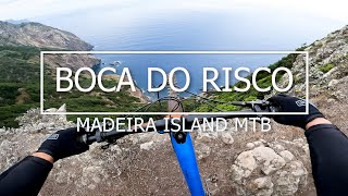
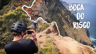
Dos trilhos mais belos do Mundo.
Trilho inicialmente feito por antepassados para se deslocarem da zona norte para o sul, onde a pé era difícil circular.

Em 2013, 2014 e 2015 foi sendo alvo de algumas intervenções a nível do solo para que as bicicletas de Enduro pudessem ali circular em segurança e menos perto do precipício.

Depois mais tarde e já em 2017 com a vinda do Enduro World Series - Madeira a organização resolveu fazer uma nova intervenção de fundo e melhoraram o trajecto para que fizesse parte do EWS na penúltima etapa, SS8.

Tem um declive muito acentuado no inicio com passagem arrepiaste sempre a beira do Rochedo, com precipícios de arrepiar impróprio para quem tem vertigens, já na sua metade mais seguro com muita rocha descendo a meio de um vale grande até chegar a Cidade de Machico.

Este trilho é muito famoso pela sua incidencia com a natureza vendo o mar a sua esquerda de quem desce e não é por nada que em 2017 foi nomeado como um dos melhores trilhos do Mundo para a prática do Enduro. Muitas revistas e Filmakers gostam de se deslocar a este sitio para captação de imagem como forma de divulgar os seus produtos, tal como fez a Absolut Black (patrocinador oficial do EWS Madeira 2017) que filmou com os Fundadores da FREERiDE MADEiRA o seu video de divulgação da marca para os seus pratos ovais.

Trail Supporters

  • 2017 - 2018
    Maintainer
Local Trail Association

Recent Activity on Trail

Past Week
  • 0 rides
  •  
6 Months
  • 26 rides
  • 26 miles avg distance
All
  • 146 rides
  • Last: Jun 13, 2026
c1c2c3c4
January
February
March
April
May
June
July
August
September
October
November
December
Status:
on May 1, 2026
Ideal
Avg: 4.55 (12 votes)
Your vote: 0

view (1,312)
close
3D
Trail Conditions
  • Unknown
  • Snow Groomed
  • Snow Packed
  • Snow Covered
  • Snow Cover Partial
  • Freeze/thaw Cycle
  • Icy
  • Prevalent Mud
  • Wet
  • Variable
  • Ideal
  • Dry
  • Very Dry
Trail Flow (Ridden Direction)
Trailforks scans users ridelogs to determine the most popular direction each trail is ridden. A good flowing trail network will have most trails flowing in a single direction according to their intension.
The colour categories are based on what percentage of riders are riding a trail in its intended direction.
  • > 96%
  • > 90%
  • > 80%
  • > 70%
  • > 50%
  • < 50%
  • bi-directional trail
  • no data
Trail Last Ridden
Trailforks scans ridelogs to determine the last time a trail was ridden.
  • < 2 days
  • < 1 week
  • < 2 weeks
  • < 1 month
  • < 6 months
  • > 6 months
Trail Ridden Direction
The intended direction a trail should be ridden.
  • Downhill Only
  • Downhill Primary
  • Both Directions
  • Uphill Primary
  • Uphill Only
  • One Direction
Contribute Details
Colors indicate trail is missing specified detail.
  • Description
  • Photos
  • Description & Photos
  • Videos
Trail Popularity ?
Trailforks scans ridelogs to determine which trails are ridden the most in the last 9 months. Trails are compared with nearby trails in the same city region with a possible 25 colour shades. Think of this as a heatmap, more rides = more kinetic energy = warmer colors.
  • most popular
  • popular
  • less popular
  • not popular
ATV/ORV/OHV Filter
Max Vehicle Width
inches
US Cell Coverage
Legend
cell carrier legend

Radar Time
Activity Recordings
Trailforks uses anonymized public activity data. ?
Activity Recordings
Trailforks uses anonymized public activity data. ?
Personal Heatmap
Activity Types
all / none
Options
2
Date range month
Winter Trails
Warning A routing network for winter maps does not exist. Selecting trails using the winter trails layer has been disabled.
Missing Trails
Most Popular
Least Popular
Trails are colored based on popularity. The more popular a trail is, the more red. Less popular trails trend towards green.
Jump Magnitude Heatmap
Heatmap of where riders jump on trails. Zoom in to see individual jumps, click circles to view jump details.
BC Backroad Status

Service Road Atlas is a free to use, community-driven service for viewing and creating reports on the numerous back-country service roads around B.C. and Alberta.

map legend
Slope Aspect
Direction the slope faces
Flat N NE E SE S SW W NW
Trails Deemphasized
Trails are shown in grey.
disable
Only show trails with no bike usage.
Enable
Suggested Layers
Based on selected activity type

    Save the current map location and zoom level as your default home location whenever this page is loaded.

    Save
        Directions to boca-do-risco trailhead (32.748560, -16.795360)

        Photos

        76 more »
        44 |
        Oct 21, 2025 @ 12:54pm
        Oct 21, 2025
        63 |
        Jun 24, 2025 @ 4:51am
        Jun 24, 2025
        67 |
        Jun 24, 2025 @ 4:51am
        Jun 24, 2025
        42 |
        May 15, 2025 @ 10:57pm
        May 15, 2025

        Videos

        7 more »
        youtuber Madeira Island MTB 'BOCA DO RISCO'
        8:40 | 928 | Feb 25, 2023 , Funchal
        youtuber Changement de décor: défis techniques et...
        24:05 | 184 | Jun 15, 2024 , Funchal
        youtuber Ride de rêve à Madère : loam, crêtes et...
        18:37 | 175 | May 24, 2024 , Funchal
        youtuber Une aventure de vélo de montagne...
        22:06 | 280 | May 17, 2024 , Funchal

        Routes with this trail

        5.0 20 miles 2,142 ft 11 Point to Point
        Muito puxado fisicamente, muita descida, muito pedal em plano e pouca subida, vários níveis técnicos ao...
        26 miles 4,609 ft 3 Point to Point Race
        41 miles 8,603 ft 9 Race
        TransMadeira 2023: day 1

        1 Review & Comments


        We hope you've been enjoying Trailforks!

        Create a FREE account to view trail comments and much more.

        • By cliogtt & contributors
        • #30638 - 7,279 views

        Frequently Asked Questions About Boca do Risco

        Where is Boca do Risco located?
        Boca do Risco is located in Machico, Funchal, Portugal. It is part of the Machico trail network. The trailhead is located at coordinates 32.74856, -16.79536.
        How hard is Boca do Risco?
        Boca do Risco is rated as Red difficulty. The physical rating is Hard. The average grade is 6%. The climb difficulty is rated Black Diamond.
        What is the elevation gain for Boca do Risco?
        Boca do Risco has 94 m of elevation gain. The trail has 331 m of elevation descent. The elevation ranges from 350 m to 615 m.
        Is Boca do Risco a point to point trail?
        Yes, Boca do Risco is a point to point trail. The direction is Downhill Only. The trail type is singletrack.

        Hit the Trail

        Open in App

        Get this trail on your phone instantly.
        open trail in app

        Download Trail

        Save to wishlist, Garmin & download.
        save the trail

        Find Related Routes

        Find routes and users activities that include this trail.
        find routes for this trail

        You must enter a description before submitting.