
Open in App
Get this trail on your phone instantly.

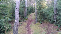
EN: Natural trail from the ridge all the way down to the village of Vallcebre. Steeper at the start and fun all the way down. At the start it's clear where to go but about mid-way down you have to keep a check on the GPS-track.
Generally it's single trail but you have about a bit of gravel road to connect to the last trail.
ES: La bajada empieza empinado y muy rápido, luego va cambiando estilo. Al principio es evidente donde ir pero a partir de la mitad hay que estar atento al GPS. En general es sendero pero hay un tramo de pista para conectar al ultimo trosito de sendero.
| c1 | c2 | c3 | c4 |
|---|---|---|---|
January | February | March | April |
May | June | July | August |
September | October | November | December |

Service Road Atlas is a free to use, community-driven service for viewing and creating reports on the numerous back-country service roads around B.C. and Alberta.
Save the current map location and zoom level as your default home location whenever this page is loaded.
SaveWe hope you've been enjoying Trailforks!
Create a FREE account to view trail comments and much more.
You must enter a description before submitting.

