more stats
4.9 miles
Distance
376 ft
Climb
-1,026 ft
Descent
00:49:02
Avg time
-651 ft
Altitude change
711 ft
Altitude min
1,631 ft
Altitude max
1,631 ft
Altitude start
981 ft
Altitude end
-2.5%
Grade
-28.1%
Grade max
31%
Grade min
1 mile
Distance climb
3 miles
Distance down
1,437 ft
Distance flat
00:49:02
Avg time

Bomb Dog Details

  • Activities
    • Mountain Bike
    • E-Bike
    • Hike
    • Trail Running
  • Riding Area
    Coldwater Mountain
    Anniston, Alabama
  • Difficulty Rating
  • Voted Difficulty
    Blue (1 vote)
  • Local Popularity
    75 in Mountain Biking [+]
    • 85 in E-Biking
    • 60 in Trail Running
    • 5 in Hiking
  • Global Ranking
    #3478 in Mountain Biking [+]
    • #83841 in Hiking
  • Trail Type
    Singletrack
  • Bike Type
    DH, AM
  • Direction
    One Direction
    Popular Direction Shown
  • Physical Rating
    Moderate
  • Trail Visibility
    Always easy to follow
  • Dogs Allowed
    Yes
  • eBike Allowed
  • TTFs on Trail
    Berm, Jump

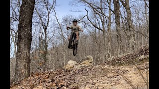
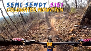
Bomb Dog is a very fast descent that is almost 4 miles in length. The trail begins at the end of Cassidy. Before you get into the descent stop and have a visit with Floyd, Anniston/Calhoun County's first bomb sniffing police canine. His headstone is just on the left of the trail. From here get ready for one of the newest and best flow-style descents available anywhere. It's about two miles long and features plenty of rollers, camel and table-top jumps. This section of trail is very progressive and is super fun for riders of all abilities. Getting air is up to you After the big descent you'll keep the smile as you contour, climb and have another short descent. The final climb brings you back to Baby Bear and the trailhead.

Traditionally Indigenous Territory

Recent Activity on Trail

Past Week
  • 1 rides
  • 18 miles average
6 Months
  • 40 rides
  • 18 miles avg distance
All
  • 430 rides
  • Last: Jun 17, 2026
c1c2c3c4
January
February
March
April
May
June
July
August
September
October
November
December
update trails status or condition

Bomb Dog Trail Reports

statusdatedescription
Mar 6, 2026 @ 9:22am (America/Kentucky/Monticello)
Mar 6, 2026
Not as much fun as I was hoping. Wish I had gone back and did Hare again.
Nov 27, 2025 @ 1:49pm (America/Kentucky/Monticello)
Nov 27, 2025
Oct 13, 2025 @ 9:11am (America/Kentucky/Monticello)
Oct 13, 2025
Jun 8, 2025 @ 2:14pm
Jun 8, 2025
May 4, 2025 @ 4:47am
May 4, 2025
Upper bomb dog is closed for a couple more weeks. We are reworking it. Please do not cross the caution tape!
more »
Status:
on Mar 6, 2026
Variable
Avg: 4.72 (27 votes)
Your vote: 0

view (2,444)
close
3D
Trail Conditions
  • Unknown
  • Snow Groomed
  • Snow Packed
  • Snow Covered
  • Snow Cover Partial
  • Freeze/thaw Cycle
  • Icy
  • Prevalent Mud
  • Wet
  • Variable
  • Ideal
  • Dry
  • Very Dry
Trail Flow (Ridden Direction)
Trailforks scans users ridelogs to determine the most popular direction each trail is ridden. A good flowing trail network will have most trails flowing in a single direction according to their intension.
The colour categories are based on what percentage of riders are riding a trail in its intended direction.
  • > 96%
  • > 90%
  • > 80%
  • > 70%
  • > 50%
  • < 50%
  • bi-directional trail
  • no data
Trail Last Ridden
Trailforks scans ridelogs to determine the last time a trail was ridden.
  • < 2 days
  • < 1 week
  • < 2 weeks
  • < 1 month
  • < 6 months
  • > 6 months
Trail Ridden Direction
The intended direction a trail should be ridden.
  • Downhill Only
  • Downhill Primary
  • Both Directions
  • Uphill Primary
  • Uphill Only
  • One Direction
Contribute Details
Colors indicate trail is missing specified detail.
  • Description
  • Photos
  • Description & Photos
  • Videos
Trail Popularity ?
Trailforks scans ridelogs to determine which trails are ridden the most in the last 9 months. Trails are compared with nearby trails in the same city region with a possible 25 colour shades. Think of this as a heatmap, more rides = more kinetic energy = warmer colors.
  • most popular
  • popular
  • less popular
  • not popular
ATV/ORV/OHV Filter
Max Vehicle Width
inches
US Cell Coverage
Legend
cell carrier legend

Radar Time
Activity Recordings
Trailforks uses anonymized public activity data. ?
Activity Recordings
Trailforks uses anonymized public activity data. ?
Personal Heatmap
Activity Types
all / none
Options
2
Date range month
Winter Trails
Warning A routing network for winter maps does not exist. Selecting trails using the winter trails layer has been disabled.
Missing Trails
Most Popular
Least Popular
Trails are colored based on popularity. The more popular a trail is, the more red. Less popular trails trend towards green.
Jump Magnitude Heatmap
Heatmap of where riders jump on trails. Zoom in to see individual jumps, click circles to view jump details.
BC Backroad Status

Service Road Atlas is a free to use, community-driven service for viewing and creating reports on the numerous back-country service roads around B.C. and Alberta.

map legend
Slope Aspect
Direction the slope faces
Flat N NE E SE S SW W NW
Trails Deemphasized
Trails are shown in grey.
disable
Only show trails with no bike usage.
Enable
Suggested Layers
Based on selected activity type

    Save the current map location and zoom level as your default home location whenever this page is loaded.

    Save
        Directions to bomb-dog trailhead (33.619790, -85.886320)

        Photos

        36 more »
        181 |
        May 28, 2022 @ 9:00pm
        May 28, 2022
        193 |
        Dec 22, 2020 @ 9:53am
        Dec 22, 2020
        230 |
        Dec 22, 2020 @ 9:53am
        Dec 22, 2020
        207 |
        Dec 14, 2020 @ 4:05am
        Dec 14, 2020

        Videos

        6 more »
        youtuber Bomb Dog Mountain Bike Trail - MTBing...
        16:31 | 532 | Apr 17, 2021 , Anniston
        youtuber Last weekend on the YT Jeffsy!
        10:59 | 1058 | Mar 24, 2020 , Anniston
        Party Pace at Coldwater Mountain
        2:11 | 383 | Jan 17, 2022 , Anniston
        youtuber We left fully satisfied at Coldwater Mountain.
        13:10 | 419 | Mar 6, 2020 , Anniston

        Routes with this trail

        5.0 14 miles 1,581 ft 8 Loop
        A good 14 mile loop at Coldwater Mountain. Start at the official Trailhead, ride the bears, then climb up...
        5.0 8 miles 1,099 ft 6 Loop
        The most direct climb to top of Bomb Dog
        4.0 20 miles 3,078 ft 12
        Go Nuts route plan for Coldwater

        7 Reviews & Comments


        We hope you've been enjoying Trailforks!

        Create a FREE account to view trail comments and much more.

        Nearby Trails

        • By softbatchTF Pro & contributors
        • #85290 - 5,603 views

        Frequently Asked Questions About Bomb Dog

        Where is Bomb Dog located?
        Bomb Dog is located in Coldwater Mountain, Anniston, Alabama, United States. It is part of the Coldwater Mountain trail network. The trailhead is located at coordinates 33.61979, -85.88632.
        How hard is Bomb Dog?
        Bomb Dog is rated as Blue difficulty. The physical rating is Moderate. The average grade is 2.5%.
        What is the elevation gain for Bomb Dog?
        Bomb Dog has 376 ft of elevation gain. The trail has 1,026 ft of elevation descent. The elevation ranges from 711 ft to 1,631 ft.
        Is Bomb Dog a point to point trail?
        Yes, Bomb Dog is a point to point trail. The direction is One Direction. The trail type is singletrack.

        Hit the Trail

        Open in App

        Get this trail on your phone instantly.
        open trail in app

        Download Trail

        Save to wishlist, Garmin & download.
        save the trail

        Find Related Routes

        Find routes and users activities that include this trail.
        find routes for this trail

        You must enter a description before submitting.