more stats
1,663 ft
Distance
3 ft
Climb
-70 ft
Descent
00:03:13
Avg time
-65 ft
Altitude change
545 ft
Altitude min
615 ft
Altitude max
615 ft
Altitude start
551 ft
Altitude end
-3.9%
Grade
-12.1%
Grade max
3.1%
Grade min
207 ft
Distance climb
1,191 ft
Distance down
266 ft
Distance flat
00:03:13
Avg time

Bonestorm Details

  • Activities
    • Mountain Bike
    • E-Bike
  • Riding Area
    Cumberland trail network
    Cumberland, British Columbia
  • Difficulty Rating
  • Voted Difficulty
    Blue (3 votes)
  • Local Popularity
    100 in Mountain Biking [+]
    • 100 in E-Biking
  • Global Ranking
    #2432 in Mountain Biking [+]
    • #2568 in E-Biking
  • Trail Type
    Singletrack
  • Bike Type
    DH, AM
  • Direction
    Downhill Primary
    Popular Direction Shown
  • Physical Rating
    Hard
  • Trail Visibility
    Always easy to follow
  • Family Friendly
    Yes
  • Dogs Allowed
    Yes
  • eBike Allowed
  • TTFs on Trail
    Rock Face

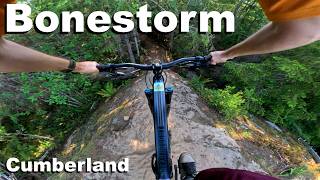
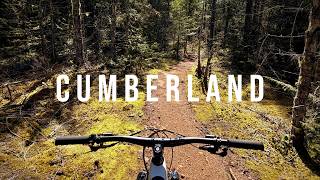
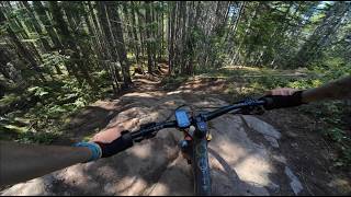
Great trail to finish a ride on or to hit a fast lap in from 2 flats. This trail is a fast flowing handbuilt trail with one alternative route technical and fast feature. The feature is a single line on a steep rockface and is steep and technical. It's very easy to avoid this feature by taking the left at the fork in the trail. The right line leads you into the rock roll down, which you need to do with no brakes to hit the double at the bottom. It's fun and rollable. Built by Coryfreerider in 2018/19
Note: if you are traveling up trail on foot, please be aware of fast moving mountain bikes and avoid stopping in blind spot areas and at the foot of technical features.

Local Trail Association

Recent Activity on Trail

Past Week
  • 89 rides
  • 15.2 km average
6 Months
  • 1,756 rides
  • 17.5 km avg distance
All
  • 8,881 rides
  • Last: Jun 27, 2026
c1c2c3c4
January
February
March
April
May
June
July
August
September
October
November
December
Status:
on Jun 24, 2026
Very Dry
Avg: 4.51 (49 votes)
Your vote: 0

view (34,843)
close
3D
Trail Conditions
  • Unknown
  • Snow Groomed
  • Snow Packed
  • Snow Covered
  • Snow Cover Partial
  • Freeze/thaw Cycle
  • Icy
  • Prevalent Mud
  • Wet
  • Variable
  • Ideal
  • Dry
  • Very Dry
Trail Flow (Ridden Direction)
Trailforks scans users ridelogs to determine the most popular direction each trail is ridden. A good flowing trail network will have most trails flowing in a single direction according to their intension.
The colour categories are based on what percentage of riders are riding a trail in its intended direction.
  • > 96%
  • > 90%
  • > 80%
  • > 70%
  • > 50%
  • < 50%
  • bi-directional trail
  • no data
Trail Last Ridden
Trailforks scans ridelogs to determine the last time a trail was ridden.
  • < 2 days
  • < 1 week
  • < 2 weeks
  • < 1 month
  • < 6 months
  • > 6 months
Trail Ridden Direction
The intended direction a trail should be ridden.
  • Downhill Only
  • Downhill Primary
  • Both Directions
  • Uphill Primary
  • Uphill Only
  • One Direction
Contribute Details
Colors indicate trail is missing specified detail.
  • Description
  • Photos
  • Description & Photos
  • Videos
Trail Popularity ?
Trailforks scans ridelogs to determine which trails are ridden the most in the last 9 months. Trails are compared with nearby trails in the same city region with a possible 25 colour shades. Think of this as a heatmap, more rides = more kinetic energy = warmer colors.
  • most popular
  • popular
  • less popular
  • not popular
ATV/ORV/OHV Filter
Max Vehicle Width
inches
US Cell Coverage
Legend
cell carrier legend

Radar Time
Activity Recordings
Trailforks uses anonymized public activity data. ?
Activity Recordings
Trailforks uses anonymized public activity data. ?
Personal Heatmap
Activity Types
all / none
Options
2
Date range month
Winter Trails
Warning A routing network for winter maps does not exist. Selecting trails using the winter trails layer has been disabled.
Missing Trails
Most Popular
Least Popular
Trails are colored based on popularity. The more popular a trail is, the more red. Less popular trails trend towards green.
Jump Magnitude Heatmap
Heatmap of where riders jump on trails. Zoom in to see individual jumps, click circles to view jump details.
BC Backroad Status

Service Road Atlas is a free to use, community-driven service for viewing and creating reports on the numerous back-country service roads around B.C. and Alberta.

map legend
Slope Aspect
Direction the slope faces
Flat N NE E SE S SW W NW
Trails Deemphasized
Trails are shown in grey.
disable
Only show trails with no bike usage.
Enable
Suggested Layers
Based on selected activity type

    Save the current map location and zoom level as your default home location whenever this page is loaded.

    Save
        Directions to bonestorm trailhead (49.611520, -125.025130)

        Photos

        40 more »
        735 |
        May 31, 2020 @ 11:12pm
        May 31, 2020
        782 |
        May 17, 2020 @ 11:11am
        May 17, 2020
        90 |
        Sep 1, 2025 @ 8:52am
        Sep 1, 2025
        105 |
        Aug 30, 2024 @ 1:18pm
        Aug 30, 2024

        Videos

        19 more »
        youtuber Bonestorm - Cumberland, BC
        2:31 | 610 | Mar 10, 2024 , Cumberland
        Bonestorm - Cumberland 2026
        0:45 | 40 | Jun 7, 2026 , Cumberland
        youtuber Cumberland Rocks and Flow - Lower Mountain Laps
        4:18 | 168 | Apr 11, 2026 , Cumberland
        200+ km's of Mountain Biking Trails |...
        13:55 | 121 | Jul 27, 2025 , Cumberland

        Routes with this trail

        2.5 4 miles 540 ft 8
        12hrs of Cumberland 2026 is a 7.5 km race route in Cumberland BC, including, Presidents Choice, Bonestorm,...
        2.5 19 miles 2,925 ft 23
        BCBR Stage 7 Cumberland. A faster take on the trail networks. All the flow. Great climbing.
        17 miles 2,616 ft 20
        BCBR 2026 Stage 1

        4 Reviews & Comments


        We hope you've been enjoying Trailforks!

        Create a FREE account to view trail comments and much more.

        • By Kriptic & contributors
        • #287426 - 6,143 views

        Frequently Asked Questions About Bonestorm

        Where is Bonestorm located?
        Bonestorm is located in Cumberland trail network, Cumberland, British Columbia, Canada. It is part of the Cumberland trail network trail network. The trailhead is located at coordinates 49.61152, -125.02513.
        How hard is Bonestorm?
        Bonestorm is rated as Black Diamond difficulty. The physical rating is Hard. The average grade is 3.9%.
        What is the elevation gain for Bonestorm?
        Bonestorm has 3 ft of elevation gain. The trail has 70 ft of elevation descent. The elevation ranges from 545 ft to 615 ft.
        Is Bonestorm a point to point trail?
        Bonestorm is not a point to point trail. The direction is Downhill Primary. The trail type is singletrack.

        Hit the Trail

        Open in App

        Get this trail on your phone instantly.
        open trail in app

        Download Trail

        Save to wishlist, Garmin & download.
        save the trail

        Find Related Routes

        Find routes and users activities that include this trail.
        find routes for this trail

        You must enter a description before submitting.