more stats
2.8 miles
Distance
1,363 ft
Climb
01:17:09
Avg time
1,365 ft
Altitude change
424 ft
Altitude min
1,788 ft
Altitude max
424 ft
Altitude start
1,788 ft
Altitude end
9.2%
Grade
-1.4%
Grade max
38.7%
Grade min
3 miles
Distance climb
95 ft
Distance down
85 ft
Distance flat
01:17:09
Avg time

Boo Hoff Trail Details

  • Activities
    • Mountain Bike
    • Hike
    • Trail Running
  • Riding Area
    La Quinta Cove
    La Quinta, California
  • Difficulty Rating
  • Local Popularity
    30 in Mountain Biking [+]
    • 60 in Trail Running
    • 65 in Hiking
  • Global Ranking
    #112553 in Mountain Biking [+]
    • #60760 in Trail Running
    • #50288 in Hiking
  • Trail Type
    Singletrack
  • Bike Type
    AM, XC
  • Direction
    Both Directions
  • Climb Difficulty
    Black Diamond
  • Physical Rating
    Hard
  • Season
    Year-round
  • Dogs Allowed
    Yes
  • TTFs on Trail
    Berm, Rock Garden, Roller Coaster, Skinny
  • Land Owner
    Santa Rosa and San Jacinto National Monument

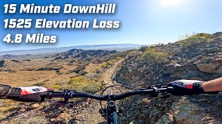
Boo Hoff Trail is a solid singletrack ride option from the La Quinta cove with a great climb and downhill. Like most of the trails in the Coachella Valley, this one is rocky and a bit technical. It has a good 3.5-mile climb with 1500 ft of elevation gained. However, the singletrack downhill makes the climb well worth the effort.

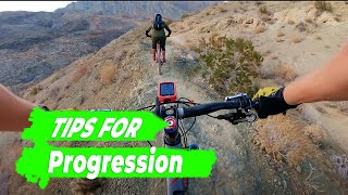
There are a couple of short branches off of the main trail during the first half of the ride that are worth exploring.

Access Info

Take Jefferson Street to the the La Quinta Cove to Lake Cahuilla Trail that will bring you back to the start.

Trail Supporters
  • BLM
    BLM
    Land Manager
Local Trail Association
Traditionally Indigenous Territory

Recent Activity on Trail

Past Week
  • 0 rides
  •  
6 Months
  • 7 rides
  • 10 miles avg distance
All
  • 24 rides
  • Last: May 26, 2026
c1c2c3c4
January
February
March
April
May
June
July
August
September
October
November
December
update trails status or condition

Boo Hoff Trail Trail Reports

statusdatedescription
Dec 6, 2023 @ 12:44pm
Dec 6, 2023
Jan 11, 2022 @ 8:44am
Jan 11, 2022
HAB up, with great views, and lots of sweating. The most exposed section is about 50m at the very start, after that a fall would hurt, but not be...
Jan 28, 2021 @ 10:28am
Jan 28, 2021
Rode from West end (Cove TH) to wilderness boundary and back. In great shape from recent rains,
Feb 3, 2019 @ 8:43pm
Feb 3, 2019
Rocky, technical, lots of switchbacks, exposure, tough climbing, good grip after the recent rains
May 22, 2017 @ 11:25pm
May 22, 2017
Wilderness, you shall not pass!!
more »
Status:
on Dec 6, 2023
Dry
Avg: 3.99 (5 votes)
Your vote: 0

view (145)
close
3D
Trail Conditions
  • Unknown
  • Snow Groomed
  • Snow Packed
  • Snow Covered
  • Snow Cover Partial
  • Freeze/thaw Cycle
  • Icy
  • Prevalent Mud
  • Wet
  • Variable
  • Ideal
  • Dry
  • Very Dry
Trail Flow (Ridden Direction)
Trailforks scans users ridelogs to determine the most popular direction each trail is ridden. A good flowing trail network will have most trails flowing in a single direction according to their intension.
The colour categories are based on what percentage of riders are riding a trail in its intended direction.
  • > 96%
  • > 90%
  • > 80%
  • > 70%
  • > 50%
  • < 50%
  • bi-directional trail
  • no data
Trail Last Ridden
Trailforks scans ridelogs to determine the last time a trail was ridden.
  • < 2 days
  • < 1 week
  • < 2 weeks
  • < 1 month
  • < 6 months
  • > 6 months
Trail Ridden Direction
The intended direction a trail should be ridden.
  • Downhill Only
  • Downhill Primary
  • Both Directions
  • Uphill Primary
  • Uphill Only
  • One Direction
Contribute Details
Colors indicate trail is missing specified detail.
  • Description
  • Photos
  • Description & Photos
  • Videos
Trail Popularity ?
Trailforks scans ridelogs to determine which trails are ridden the most in the last 9 months. Trails are compared with nearby trails in the same city region with a possible 25 colour shades. Think of this as a heatmap, more rides = more kinetic energy = warmer colors.
  • most popular
  • popular
  • less popular
  • not popular
ATV/ORV/OHV Filter
Max Vehicle Width
inches
US Cell Coverage
Legend
cell carrier legend

Radar Time
Activity Recordings
Trailforks uses anonymized public activity data. ?
Activity Recordings
Trailforks uses anonymized public activity data. ?
Personal Heatmap
Activity Types
all / none
Options
2
Date range month
Winter Trails
Warning A routing network for winter maps does not exist. Selecting trails using the winter trails layer has been disabled.
Missing Trails
Most Popular
Least Popular
Trails are colored based on popularity. The more popular a trail is, the more red. Less popular trails trend towards green.
Jump Magnitude Heatmap
Heatmap of where riders jump on trails. Zoom in to see individual jumps, click circles to view jump details.
BC Backroad Status

Service Road Atlas is a free to use, community-driven service for viewing and creating reports on the numerous back-country service roads around B.C. and Alberta.

map legend
Slope Aspect
Direction the slope faces
Flat N NE E SE S SW W NW
Trails Deemphasized
Trails are shown in grey.
disable
Only show trails with no bike usage.
Enable
Suggested Layers
Based on selected activity type

    Save the current map location and zoom level as your default home location whenever this page is loaded.

    Save
        Directions to boo-hoff-trail trailhead (33.641270, -116.309390)

        Photos

        116 more »
        31 |
        Dec 23, 2023 @ 4:57pm
        Dec 23, 2023
        36 |
        Dec 23, 2023 @ 4:57pm
        Dec 23, 2023
        122 |
        Jan 28, 2022 @ 9:39pm
        Jan 28, 2022
        77 |
        Jan 25, 2022 @ 7:50am
        Jan 25, 2022

        Videos

        13 more »
        youtuber From Top To Bottom - Boo Hoff Trail,  La...
        19:56 | 284 | May 21, 2024 , La Quinta
        youtuber Tips to Progress Your Mountain Bike Skills :...
        7:14 | 424 | Jun 12, 2021 , La Quinta
        youtuber I Crashed while KOM Hunting
        4:52 | 308 | Jun 12, 2021 , La Quinta
        youtuber MTB Night Ride With Light and Motion Seca 2500...
        6:05 | 252 | Jun 12, 2021 , La Quinta

        Routes with this trail

        11 miles 2,104 ft 1 Loop
        Route linking Cove to Lake and Boo Hoff Trails, with short road route available to link finish and start.

        15 Reviews & Comments


        We hope you've been enjoying Trailforks!

        Create a FREE account to view trail comments and much more.

        • By stoker1223 & contributors
        • #80523 - 7,612 views

        Frequently Asked Questions About Boo Hoff Trail

        Where is Boo Hoff Trail located?
        Boo Hoff Trail is located in La Quinta Cove, La Quinta, California, United States. It is part of the La Quinta Cove trail network. The trailhead is located at coordinates 33.64127, -116.30939.
        How hard is Boo Hoff Trail?
        Boo Hoff Trail is rated as Black Diamond difficulty. The physical rating is Hard. The average grade is 9.2%. The climb difficulty is rated Black Diamond.
        What is the elevation gain for Boo Hoff Trail?
        Boo Hoff Trail has 1,363 ft of elevation gain. The elevation ranges from 424 ft to 1,788 ft.
        Is Boo Hoff Trail a point to point trail?
        Boo Hoff Trail is not a point to point trail. The direction is Both Directions. The trail type is singletrack.

        Hit the Trail

        Open in App

        Get this trail on your phone instantly.
        open trail in app

        Download Trail

        Save to wishlist, Garmin & download.
        save the trail

        Find Related Routes

        Find routes and users activities that include this trail.
        find routes for this trail

        You must enter a description before submitting.